


 Plan a Trip


Nepal Flash Flood Condition News
Operational and Structural Status Assessment of the Rasuwagadhi–Kerung Border Corridor Following the August 2026 Transboundary Hydrometeorological Disaster
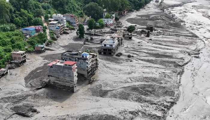
The Rasuwagadhi border crossing (Rasuwagadhi Nakha), the primary overland trade and transit gateway between Nepal and the Tibet Autonomous Region (TAR) of China, is completely non-operational after a catastrophic flash flood and hyper-concentrated debris flow on August 26, 2026. The physical border facilities, customs yards, transport links, and supporting energy infrastructure along the Bhote Koshi and Lhende Khola river corridors suffered near-total erasure or structural failure.
This incident represents the second major destruction of the crossing within a 14-month window, following a similar supraglacial-driven flood in July 2025 that severed the border for nearly six months. The August 2026 disaster far exceeded the 2025 event in both volume and destructive force, obliterating the newly installed 91-meter Bailey bridge, destroying the Gyirong Port facilities on the Chinese side, and sweeping away the Timure customs complex on the Nepali side. Restoration of normal commercial trade or passenger transit through Rasuwagadhi is not anticipated for months, compelling a structural shift in regional trade logistics, energy grid management, and Himalayan tourism.
Geological and Hydrological Trigger Mechanisms
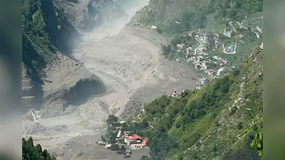
The disaster originated approximately 20 kilometers northeast of the Rasuwagadhi border point, high in the Langtang Lirung mountain mass. Satellite imagery and seismic monitoring confirmed that a massive rock-and-ice collapse involving a glacier about 610 meters wide was the primary trigger. Bedrock beneath the glacial mass failed, sending millions of cubic meters of ice, rock, and mountain substrate plunging over 1,200 meters into high-altitude valley catchments.
The physical impact of the initial collapse generated a seismic signal equivalent to a $M_s\ 5.2$ or $M_w\ 4.4$ event. While early reports attributed the disaster to an earthquake, geomorphological analysis confirmed that the seismic energy came entirely from the avalanche’s mass striking the valley floor. The resulting debris mixed with meltwater, entrained sediments, and supraglacial water bodies, forming a hyper-concentrated flow that impounded the Lhende Khola.
When this temporary landslide dam breached, a wall of water, mud, and boulders surged downstream at speeds estimated at $50\text{ m/s}$ ($180\text{ km/h}$). The floodwaters swept down the Lhende Khola into the Bhote Koshi River and rapidly progressed into the Trishuli River system. Downstream hydrographic stations recorded sudden stage increases, with the Galchhi monitoring point logging a river rise of about 99 meters within 30 minutes. Existing cross-border early warning systems failed to issue timely alerts because water-level monitoring stations upstream were physically swept away before signals could be transmitted, and sensors optimized for perennial monsoon swells were overwhelmed by the velocity of the rock-ice avalanche cascade.
Ground-Level Infrastructure Devastation and Border Operations
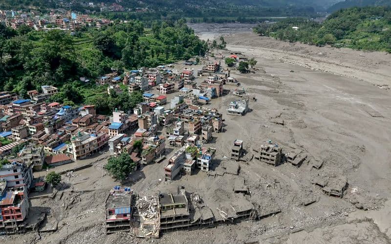
High-resolution satellite imagery captured on August 27, 2026, confirmed that the principal multi-story port complex at Gyirong (China) and the Timure customs facility (Nepal) were virtually erased. On the Nepali side, the surge swept directly through the low-lying settlements of Timure and Syabrubesi, submerging or burying customs yards, administrative buildings, security outposts, and residential structures.
The cross-border connecting infrastructure was completely severed. The 91-meter steel Bailey bridge—erected with Chinese technical assistance in late 2025 following the destruction of the historic Miteri Friendship Bridge—was torn from its abutments. More than 500 cargo trucks, container trailers, and private vehicles waiting at the border customs processing zones were carried away or buried under meters of gravel and silt.
Downstream, approximately 42 kilometers of the Pasang Lhamu Highway linking Betrawati in Nuwakot to Rasuwagadhi was washed out or severed by landslides, isolating the northern sector of Rasuwa District from overland vehicular access. Local helipads, including the facility at Timure, were carried away by the river, initially preventing aerial search-and-rescue helicopters from touching down.
| Infrastructure Component | Location | Pre-Disaster Function | Post-Disaster Status (August 2026) |
| Gyirong Port Facility | Gyirong County, TAR | Primary Chinese immigration & customs terminal | Destroyed; structural framework erased. |
| Timure Customs Hub | Timure, Rasuwa | Primary Nepali freight inspection & clearing yard | Obliterated; vehicles, yards, and offices buried or swept away. |
| Miteri / Bailey Bridge | Bhote Koshi Frontier | International overland vehicular crossing point | Destroyed; spans washed downstream. |
| Pasang Lhamu Highway | Betrawati–Rasuwagadhi | Strategic arterial road linking Kathmandu to TAR | 42 km section severed or completely washed away. |
| Timure Helipad | Timure, Rasuwa | Emergency air transport and rescue drop-point | Swept away, forcing aerial rescues to abort landing. |
| Local Telecom & Grid | Rasuwa District-wide | Cellular towers, fiber lines, local power supply | Severed; initial total communications blackout. |
The damage created acute logistical crises on both sides of the frontier. In Kerung, located roughly 30 kilometers north of the border in Tibet, at least 80 Nepali freight container drivers became stranded when the route south was cut. With the border road destroyed and damaged sections extending up to 5 kilometers into Tibetan territory, repatriation via Rasuwagadhi remains physically impossible. Transboundary municipal authorities have begun discussing rerouting stranded personnel via alternative mountain passes, such as Tatopani (300 km distant) or Korala (over 600 km distant).
Humanitarian Impact and Spatial Distribution of Casualties
The flood wave propagated along a 72-kilometer stretch of the Trishuli River corridor, impacting settlements across eight districts in central and southern Nepal, as well as Gyirong County in Tibet. The casualty footprint extends far beyond the immediate border zone, as victims and structural debris were carried downstream into the Narayani and Trishuli river basins, with bodies recovered as far as 240 kilometers away in the Indian states of Uttar Pradesh and Bihar.
Provisional data compiled by disaster response authorities indicates nationwide fatalities exceeding 620 individuals, with over 2,400 people listed as unaccounted for. A significant percentage of those listed as missing reflects collapsed telecommunication networks across mountain catchments rather than confirmed deaths. The disaster heavily impacted vulnerable populations, including a community of 250 households displaced by the 2015 Gorkha earthquake who had resettled along the low-lying riverbanks of the Trishuli; their settlement was swept away entirely.
| District / Region | Confirmed Recovered Fatalities | Formally Reported Missing | Primary Casualty Groups / Context |
|---|---|---|---|
| Chitwan | 108+ | Unspecified | Downstream flash flood inundation along Narayani/Trishuli. |
| Nawalparasi East | 62–74 | Unspecified | Downstream river surge victims carried from upper valleys. |
| Dhading | 27 | Unspecified | Riverside market settlements destroyed by debris flow. |
| Gorkha | 20 | Unspecified | Tributary flooding and bank erosion along Trishuli basin. |
| Rasuwa | 17+ | 384+ | Customs staff, APF personnel, residents, trekkers. |
| Tibet Autonomous Region | 7+ | 554+ | Port workers, border security staff, residents. |
| Total (Cumulative) | 623+ | 2,478+ | Includes domestic residents, trade personnel, and foreign nationals. |
The human toll includes foreign tourists, trekking crews, and international pilgrims trapped in the border transit zone. An entire overland Kailash Yatra pilgrimage group organized by a major tour operator, comprising 40 foreign nationals (from the United States, Canada, Australia, the United Kingdom, Singapore, and Russia) and 7 Nepali field staff, was caught at Rasuwagadhi during the surge, triggering international search-and-rescue interventions. Security personnel deployed at border outposts were also hit; multiple members of the Armed Police Force (APF), Nepal Police, and Nepal Army stationed at Timure were swept away.
Cascading Sectoral Impacts
Energy Grid Paralysis and Hydropower Infrastructure
The Bhote Koshi–Trishuli river corridor represents Nepal’s most concentrated hydroelectric energy generation artery. The August 26 surge caused structural damage or operational paralysis across 14 solar and hydroelectric facilities, representing approximately 748 megawatts (MW) of generation capacity.
Active generation facilities knocked offline include the 102 MW Rasuwagadhi Hydropower Project, the 221 MW Chilime Hydropower complex, the Trishuli 3A plant, the 220 kV Trishuli 3B hub substation, the Trishuli Hydropower Station, and the Devighat plant. In total, over 430 MW of active generation capacity was removed from the national grid instantly, causing rolling voltage fluctuations and power deficits across Bagmati and Gandaki provinces. Heavy siltation, submerged turbines, swept-away penstocks, and damaged transformer hubs mean that bringing these facilities back online will require extensive dredging and electromechanical repairs lasting months.
Transboundary Trade and Macroeconomic Pressures
The destruction of Rasuwagadhi paralyzes Nepal’s primary overland commercial artery with China. Since the 2015 earthquake damaged the historic Tatopani–Zhangmu (Kodari) border point on the Araniko Highway, Rasuwagadhi has absorbed most northern transboundary container traffic, carrying vital shipments of garments, electronics, industrial raw materials, and agricultural goods.
The timing of the disaster imposes severe macroeconomic costs. The closure occurred just weeks before the major autumn festival season (Dashain and Tihar), when consumer demand peaks across Nepal and import volumes through Rasuwagadhi traditionally surge. Importers face stranded cargo on the Chinese side, contractual default risks, and surging freight costs. The secondary Tatopani crossing cannot absorb the redirected container volume due to lingering structural bottlenecks on the Araniko Highway. Consequently, commercial supply chains in Kathmandu are experiencing immediate price volatility, cargo delays, and shortages of seasonal consumer goods.
Tourism Logistics and Regional Safety Disparity
The destruction of the border hub has altered regional tourism logistics, requiring a clear operational distinction between the affected corridor and the rest of the country. The overland route to Tibet and Mount Kailash via Kerung is shut for the remainder of the 2026 travel season. Travel agencies operating overland Tibet itineraries have canceled departures or transitioned clients to fly-in routes connecting Kathmandu to Lhasa’s Gonggar Airport. Similarly, vehicle access to the gateway towns of Syabrubesi and Timure for the Langtang Valley trek is severed.
Conversely, Nepal’s broader tourism infrastructure outside the affected watershed remains fully operational. Major trekking sectors—including the Everest (Khumbu) region, Annapurna Circuit and Base Camp, Manaslu Circuit, Upper Mustang, and key urban centers like Kathmandu and Pokhara—are located in separate river basins and suffered no physical impact. Flights to Lukla and Jomsom continue on standard schedules, and peak autumn trekking activities across these unaffected zones remain active.
Reconstruction Trajectory and Policy Implications
Long-Term Reconstruction Challenges
The repeated destruction of the Rasuwagadhi corridor within 14 months highlights a fundamental mismatch between traditional civil engineering standards and the reality of climate-driven mountain hazards. Reconstruction of the border crossing cannot simply replicate previous designs. Restoring vehicular transit through the Rasuwagadhi Nakha will require several key engineering adjustments:
Re-siting customs yards and border processing infrastructure onto higher bedrock terraces well above the 100-year flood line of the Bhote Koshi.
Designing multi-span, high-clearance suspension or cantilever bridges capable of withstanding hyper-concentrated debris flows laden with massive boulders.
Rebuilding the 42 km severed stretch of the Pasang Lhamu Highway using reinforced retaining structures and tunnel segments through chronic landslide zones.
Given the scale of terrain deformation, restoring full-capacity freight operations through Rasuwagadhi is projected to take 12 to 24 months, requiring joint diplomatic, financial, and engineering mobilization between Nepal and China.
- Operational and Structural Status Assessment of the Rasuwagadhi–Kerung Border Corridor Following the August 2026 Transboundary Hydrometeorological Disaster
- Geological and Hydrological Trigger Mechanisms
- Ground-Level Infrastructure Devastation and Border Operations
- Humanitarian Impact and Spatial Distribution of Casualties
- Cascading Sectoral Impacts
- Reconstruction Trajectory and Policy Implications
