Kathmandu to Panch Pokhari Trek Vehicle: The Sacred Five Lakes Within Reach of the Capital

Kathmandu to Panch Pokhari Trek Vehicle: The Sacred Five Lakes Within Reach of the Capital
Less than a hundred kilometres from the traffic and temple bells of central Kathmandu, in a fold of the Jugal Himal foothills that most visitors to Nepal will never hear mentioned, five — and by some local reckonings as many as seven or nine — high-altitude lakes sit cupped in a glacial basin at roughly 4,100 metres above sea level, ringed by snow peaks and treated, for as long as anyone in the surrounding villages can remember, as one of the most sacred places in the central Himalaya.
Panch Pokhari, literally ‘five lakes,’ is at once astonishingly close to Nepal’s capital and genuinely remote: a destination that can, in principle, be reached and returned from within a single demanding week from Kathmandu, and yet remains so lightly visited that trekkers who make the journey routinely report walking for entire days without encountering another traveler.
This combination — proximity and obscurity, holiness and wildness, all within a single weekend’s drive of one of Asia’s busiest tourist cities — is what makes Panch Pokhari worth understanding in some depth before simply listing bus times and jeep fares. The mountain it sits beneath, Jugal Himal, does not appear on any list of Nepal’s eight-thousanders or even its most photographed seven-thousanders, and the trek that leads to its lakes has never developed anything resembling the teahouse infrastructure of the Annapurna or Everest regions. Reaching Panch Pokhari is, in a meaningful sense, still an act of genuine travel rather than simply route-following — and the vehicle journey that begins that travel from Kathmandu deserves to be understood as more than a logistical footnote.
This guide sets out, in greater narrative depth than our standard route guides, both the practical mechanics of getting to Panch Pokhari by vehicle from Kathmandu and the deeper context — religious, ecological, and historical — that makes the destination worth the considerable effort involved. Nepal Vehicle Hiring Pvt Ltd provides private vehicle transport for the road sections of this journey, and what follows draws on that operational experience alongside a wider reading of the route’s history and significance.
A Sacred Lake Cluster the Modern World Almost Forgot
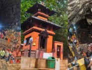
Panch Pokhari occupies a curious position in Nepal’s geography of sacred places. Unlike Muktinath or Pashupatinath, whose fame and pilgrimage infrastructure have been documented in religious texts and built up over centuries of continuous royal and institutional patronage, Panch Pokhari’s standing as a holy site appears to rest almost entirely on continuous oral tradition and the lived devotional practice of the Tamang, Sherpa, and Hindu hill communities of Sindhupalchok, Nuwakot, and Rasuwa districts, who have for generations made the demanding multi-day journey to bathe in and worship at the lakes, particularly during the festival of Janai Purnima in the Nepali month of Shrawan, when thousands of pilgrims — far outnumbering any trekking tourist traffic the route receives in an entire year — converge on the lake basin to change their sacred thread, bathe in the glacial water, and pay respect to the resident deity believed to inhabit the largest of the lakes.
This devotional intensity sits in striking contrast to how little Panch Pokhari has registered in the wider, internationally oriented apparatus of Nepali tourism. There is no Lonely Planet chapter devoted to it in the way there is for Everest Base Camp or the Annapurna Circuit, no government department actively marketing it abroad, and — strikingly, for a site of this religious importance — only the most minimal teahouse infrastructure along most approach routes, meaning that the majority of organised trekking itineraries to Panch Pokhari are still run, as they would have been decades ago, as full camping expeditions with cooking crews, tents, and porters rather than the lodge-to-lodge model that now defines trekking in Nepal’s more developed regions. One small but telling marker of the site’s underlying national significance: Nepal’s postal service selected Panch Pokhari for a commemorative postage stamp in 2011, a modest but genuine official acknowledgment of the lake’s status as a place of cultural value, issued at a time when the route remained almost entirely unknown to the international trekking market that has since begun, slowly, to discover it.
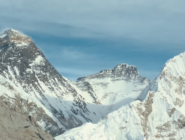
Geographically, the lakes sit at the meeting point of three administrative districts — Sindhupalchok, where the main approach routes and the rural municipality bearing the lake’s own name (Panch Pokhari Thangpal) are located, along with Nuwakot and Rasuwa, whose boundaries converge nearby — and fall within the territory of Langtang National Park, Nepal’s fourth protected area, established in 1976 primarily to safeguard the Langtang valley itself but extending its boundaries eastward to encompass this less-visited corner of the central Himalaya as well. The lake basin sits directly beneath the southern flank of the Jugal Himal range, whose principal summits — Dorje Lakpa at 6,966 metres, Phurbi Chyachu at 6,637 metres, and Madiya at 6,257 metres — form the visual centrepiece of the trek’s mountain panorama, with the more distant and more famous profiles of the Langtang Range and Ganesh Himal visible on the clearest days from the higher viewpoints along the route.
Two Gateways, Two Very Different Journeys
Reaching Panch Pokhari from Kathmandu has historically meant choosing between two distinct overland gateways, each with its own character, driving distance, and implications for how many days of subsequent walking are required to reach the lakes themselves.
The traditional, longer-established gateway runs through Chautara, the district headquarters of Sindhupalchok, which is reached from Kathmandu via the Araniko Highway. The same historic road continues onward, as covered in our dedicated Kodari border guide, all the way to the Nepal-China frontier. The Kathmandu to Chautara drive covers a road distance most commonly cited at somewhere between 72 and 100 kilometres, depending on the exact starting point in Kathmandu and the precise routing taken, and generally takes 5 to 6 hours by road — a journey that, on paper, sounds almost casually short by the standards of Nepal’s longer trekking transfers,
but which in practice can feel considerably longer given the winding, climbing character of the road as it leaves the Kathmandu Valley and ascends into the Sindhupalchok hills. From Chautara, the classic multi-day walking route proceeds through a sequence of small settlements and high pastures with names that rarely appear on any map smaller than a dedicated trekking chart — Phurse, Sano Okhareni, Thulo Okhareni, Kami Kharka, Pauwa Bas, Hile Bhanjyang, and finally Nasimpati — before the final ascent to the lake basin itself. This sequence typically requires four to six days of walking in one direction alone, depending on pace and acclimatization needs.
The newer and increasingly popular alternative gateway approaches from the west, via Melamchi Bazaar and the village of Bhotang, reached either via the Araniko Highway through Dhulikhel and a turn north at what local drivers refer to as Zero Kilo, or via the slightly different and reportedly somewhat smoother Sankhu-Melamchi road that bypasses some of the more winding sections of the Chautara approach. From Melamchi, a further stretch of local transport — frequently described by those who have made the journey as an ‘off-road express’ rattling along a track that follows the Indrawati River — leads to Bhotang village, a journey that can itself consume six to seven hours depending on the condition of this final unpaved stretch.
The genuine advantage of the Melamchi-Bhotang approach is what follows it: from Bhotang, the walking distance to Panch Pokhari is considerably shorter than from Chautara, with some operators now advertising itineraries that reach the lakes in as little as two to three days of trekking from this starting point, a substantial reduction that has made the Melamchi gateway an increasingly common choice among both Nepali domestic trekkers and the small but growing number of international visitors discovering the route.
There is, in addition, a third and more recently documented possibility for those determined to minimise walking time even further: at least one detailed independent account of the trek notes that a four-wheel-drive vehicle, with sufficiently careful and experienced driving on what is frankly described as poor road surface, can in current conditions continue beyond the standard road-head all the way to a place called Dukhang Kharka, just beyond the village of Deurali, on the approach toward Chhimti — effectively pushing the drivable road considerably further into the hills than either of the two more established gateways would suggest, though this should be treated as an emerging and somewhat informal option rather than a fully established route, and one that depends heavily on current road maintenance and the specific vehicle and driver involved.

The Drive Through Sindhupalchok — What the Road Actually Shows You
Whichever gateway is chosen, the drive out of the Kathmandu Valley toward Sindhupalchok district shares a common early character with several of the other eastern and northeastern routes described elsewhere in our blog series — the climb out through Bhaktapur and Banepa, the hilltop pause at Dhulikhel with its often spectacular view back across the terraced valley toward the distant Himalayan skyline on a clear morning, and the gradual transition from the dense urban fabric of the capital into the genuinely rural, terraced, and increasingly forested hill country that characterises most of Sindhupalchok district.
What distinguishes the approach to Chautara and the wider Panch Pokhari gateway region from the more heavily trafficked Araniko Highway corridor toward Kodari is the relative quietness of the road beyond the main highway turn-off. The increasingly visible presence of Tamang cultural markers — distinctive monastery architecture, prayer flags strung across mountain passes, and
the particular rhythm of agricultural life in villages where Tibetan Buddhist practice sits alongside, and in many households is genuinely intertwined with, the Hindu devotional traditions that also draw pilgrims to the lakes themselves. Sindhupalchok is, more than almost any other district within a half-day’s drive of Kathmandu, a place where this Tamang cultural presence remains genuinely dominant rather than diluted by the kind of rapid urbanization that has reshaped much of the immediate periphery of the Kathmandu Valley over the past three decades.
The district’s more recent history carries its own weight as well. Sindhupalchok was among the districts most severely affected by the catastrophic earthquake of April 2015. The visible evidence of reconstruction — newer concrete buildings standing beside the occasional still-damaged older structure, communities that have rebuilt with deliberate attention to earthquake-resistant design — forms an unavoidable part of the landscape a traveler passes through en route to Chautara or Melamchi today. This is not incidental background; the resilience and continuity of the pilgrimage tradition to Panch Pokhari through and beyond this period of disruption is itself a quiet testament to how deeply rooted the site’s religious significance remains in the communities of this region.
A Trek That Has Resisted the Teahouse Economy
Perhaps the single most distinctive feature of the Panch Pokhari trek, when set against the wider pattern of trekking tourism development that has transformed routes like Poon Hill, Annapurna Base Camp, and even much of the Everest region over the past three decades, is how little teahouse infrastructure has developed along its main approach corridors. Multiple independent and operator accounts of the trek explicitly describe it as a camping or semi-camping experience: a journey for which most organisers still bring tents, a cooking crew, and porters carrying kitchen equipment, precisely because the string of villages between Chautara or Bhotang and the lake basin itself does not yet offer the kind of dependable, bed-for-every-trekker lodge network that has become standard on Nepal’s more internationally developed trails.
This absence of infrastructure cuts in two directions, and both deserve honest acknowledgment. On one hand, it means Panch Pokhari remains logistically more demanding and more expensive per day than an equivalent teahouse-based trek of similar duration elsewhere in Nepal — camping treks require more staff, more equipment, and more planning, and the absence of guaranteed accommodation at each overnight stop means a degree of flexibility and self-sufficiency that a first-time Himalayan trekker, of the kind discussed in our dedicated guide for first-time visitors, may find more challenging than the relatively well-trodden Annapurna or Langtang routes.
On the other hand, it is precisely this absence of infrastructure that preserves what makes the destination genuinely special: an experience of walking for days through forest, high pasture, and finally stark alpine terrain with minimal evidence of the commercial trekking economy that has, in some of Nepal’s more famous destinations, begun to shape the character of the trail itself noticeably.
Some recent accounts of the route do note the gradual emergence of basic homestay and simple lodge accommodation in larger waypoint villages such as Bhotang, suggesting that the infrastructure picture is slowly, unevenly evolving — a pattern entirely consistent with how trekking development has historically proceeded elsewhere in Nepal, beginning with the larger gateway settlements and only gradually extending further along the trail as visitor numbers justify the investment. Travelers planning a Panch Pokhari trek in the near future should expect. They should indeed welcome a journey that still requires more self-sufficiency and more careful advance planning through a properly equipped trekking agency than the country’s headline routes — this is, in significant part, exactly what continues to make the destination worth visiting.
The Mountains That Watch Over the Lakes
The mountain panorama visible from the higher sections of the Panch Pokhari trek, and from the lake basin itself, centers on the Jugal Himal range — a comparatively little-known massif by the standards of Nepal’s most famous peaks, but one that rewards close attention precisely because of how rarely it features in the broader popular imagination of Himalayan mountaineering. Dorje Lakpa, at 6,966 meters the range’s highest summit, takes its name from a protective deity in Tibetan Buddhist cosmology and presents a dramatically fluted, ice-draped face to trekkers approaching from the south — a peak that, despite its considerable height, remains far less frequently climbed or even photographed than mountains of comparable altitude in the more heavily trafficked Khumbu or Annapurna regions.
Phurbi Chyachu, at 6,637 meters, and Madiya, at 6,257 meters, complete the immediate Jugal Himal skyline visible from the Panch Pokhari area, their names and relatively modest mountaineering history reflecting the same broader pattern of obscurity that characterizes the entire massif. On the clearest days, and from the highest viewpoints along the trekking route — particularly the ridge above Nasimpati on the traditional Chautara approach, or the viewpoint immediately above the lakes themselves — this immediate panorama extends to encompass the more distant and considerably more famous profiles of the Langtang Range to the northwest,
its highest summit Langtang Lirung reaching 7,234 metres, and Ganesh Himal further west again, at 7,422 metres one of the most visually striking peaks in the central Himalaya despite its own relative obscurity outside specialist mountaineering circles. On exceptional days, trekkers and pilgrims at Panch Pokhari report glimpsing the more distant Rolwaling Range to the east as well, completing a panorama that, in clear conditions, offers an essentially uninterrupted sweep of central Himalayan summits from a vantage point that very few foreign visitors to Nepal will ever stand upon.
The lakes themselves sit within a glacially carved basin whose physical setting — bare rock, scattered alpine tarns, and the characteristic stark beauty of terrain immediately below the permanent snowline — is itself part of the destination’s appeal, distinct in character from the more vegetated high-altitude landscapes of, for example, the Annapurna Sanctuary or the Khumbu valley floor near Everest Base Camp. Local tradition holds that the largest of the lakes never fully freezes even in the depths of winter, a detail frequently repeated by pilgrims and trekking guides alike as evidence of the site’s sacred and somewhat mysterious character, regardless of its precise hydrological explanation.

A Living Pilgrimage, Not a Historical Curiosity
It would be a mistake to approach Panch Pokhari purely through the lens of trekking tourism, however genuine and growing that interest now is. The site’s primary identity, for the communities of Sindhupalchok, Nuwakot, and Rasuwa who have sustained the pilgrimage tradition for generations, remains devotional rather than recreational. The Janai Purnima festival, falling on the full moon of the Nepali month of Shrawan (typically July or August), draws the largest annual concentration of visitors to the lake basin — substantially larger, by most accounts, than the total number of international trekkers who visit across the entire rest of the year combined.
Pilgrims undertake the same demanding multi-day approach described in this guide, often on foot for the entire journey from much further afield than Kathmandu, specifically to bathe in the lakes’ frigid water, to change the sacred janai thread worn by many Hindu men and some women as a marker of ritual purity, and to pay homage to the deity understood to reside within the largest lake.
In practical terms, this devotional dimension shapes several aspects of planning and approaching a visit to Panch Pokhari. Travelers visiting outside the Janai Purnima period will encounter a far quieter, more contemplative site — appropriate for trekkers and photographers seeking solitude — while those who specifically wish to witness or participate in the pilgrimage tradition should plan their visit deliberately around the festival date, with the understanding that accommodation and porter availability will be under considerably greater pressure during this peak devotional period than at any other time of year.
Visitors of any background are generally welcomed at the lakes with the same open hospitality that characterizes Hindu and Buddhist pilgrimage sites throughout Nepal. Still, the same baseline etiquette that applies at any of the country’s sacred sites — modest dress, respectful behavior around any pilgrims engaged in worship or ritual bathing, and a general sensitivity to the site’s primary religious function — applies with particular relevance here, given how much more central that devotional function remains at Panch Pokhari than at many of Nepal’s more internationally tourism-oriented sacred destinations.
Practical Reference — Key Facts, Routes, and Permits
| Key Fact | Detail |
| Panch Pokhari Altitude | 4,100 m (the main lake cluster; outlying lakes and ridge points reach higher) |
| Location | Sindhupalchok District (Panch Pokhari Thangpal Rural Municipality), bordering Nuwakot and Rasuwa, within Langtang National Park |
| Meaning | ‘Panch Pokhari’ translates literally as ‘Five Ponds/Lakes’ in Nepali |
| Religious Significance | Sacred to both Hindus and Buddhists; major pilgrimage gathering during Janai Purnima |
| Mountains Visible | Dorje Lakpa (6,966 m), Phurbi Chyachu (6,637 m), Madiya (6,257 m), and the wider Jugal Himal, Langtang, and Rolwaling ranges |
| Gateway Towns | Chautara (traditional, Sindhupalchok HQ) or Melamchi Bazaar / Bhotang (newer, faster approach) |
| Drive Distance from Kathmandu | Approximately 72–100 km, depending on the gateway chosen |
| National Recognition | Nepal’s postal service issued a commemorative stamp featuring Panch Pokhari in 2011 |
| Trek Character | Largely a camping/basic-lodge trek — limited teahouse infrastructure compared to Nepal’s major trekking corridors |
| Route Option | Drive Distance | Drive Time | Trek Days to Lakes | Character |
| Via Chautara (traditional) | 72–100 km | 5–6 hours | 4–6 days one way | Longer but more established; passes through Phurse, Kami Kharka, Pauwa Bas, Hile Bhanjyang, Nasimpati |
| Via Melamchi / Bhotang (newer) | ~60–80 km to Melamchi/Bhotang area | 3–4 hours to Melamchi, then 6–7 hrs further local transport/jeep to Bhotang | 2–3 days one way | Faster overall, increasingly the preferred gateway |
Private vehicle costs for this route are worth noting precisely because they differ from the more standardized pricing of Nepal’s major trekking corridors. One detailed first-hand account of the trek records a reserved eight-seat Bolero jeep, booked for the Kathmandu-to-Chhimti leg of a Melamchi-gateway itinerary, at a one-way fare of NPR 12,000 for the full vehicle — a figure consistent with the kind of private 4WD pricing seen on other moderately remote hill routes covered elsewhere in this blog series, and a useful benchmark for travelers budgeting their own Panch Pokhari journey. Nepal Vehicle Hiring Pvt Ltd provides comparable private vehicle hire — sedan for the paved sections as far as conditions allow, and 4WD Scorpio or Hilux for the rougher final approaches toward Chautara, Melamchi, Bhotang, or, where current road conditions and driver experience permit, the more advanced drop-off points toward Deurali and Chhimti.

Permits and Practical Requirements
| Permit / Requirement | Approx. Cost (2026) | Notes |
| Langtang National Park Entry Permit | NPR 3,000 (USD 22) for foreign nationals | Panch Pokhari falls within the Langtang National Park boundaries |
| TIMS Card | USD 10–20 per person | Recommended for all organized trekking groups |
| Licensed Guide | USD 20–30 per day | Mandatory under Nepal’s current trekking guide regulation; essential given limited infrastructure and lack of marked trail signage |
| Camping Equipment / Crew | Varies by operator | Most itineraries are organized as camping treks given the sparse teahouse coverage. |
Because Panch Pokhari sits within Langtang National Park, the standard national park entry permit applies. Trekkers should arrange it in Kathmandu before departure rather than assuming it can be processed informally en route, given the limited administrative infrastructure along much of the trail. The combination of high altitude, sparse trail signage, limited rescue infrastructure, and the camping-based logistics most itineraries require makes the now-mandatory licensed guide requirement considerably more than a bureaucratic formality on this particular route — local knowledge of the trail, the weather, and the specific demands of the various overnight stops is genuinely important here in a way that it may not be on Nepal’s better-signed and more heavily trafficked major trekking corridors.

Season, Altitude, and Honest Expectations
The two recommended trekking windows for Panch Pokhari follow the same broad seasonal logic that governs trekking across most of Nepal: spring, roughly March through May, when rhododendron forests along the lower sections of the trail come into vivid bloom and temperatures at altitude become more tolerable without yet bringing the full intensity of pre-monsoon haze; and autumn, roughly September through November or into early December by some operators’ reckoning, when post-monsoon air clarity delivers the sharpest possible views of the Jugal Himal, Langtang, and Ganesh Himal panorama from the lake basin and surrounding ridges.
At a maximum altitude of approximately 4,100 meters — with some accounts suggesting nearby ridge viewpoints and outlying lake features reach somewhat higher still — Panch Pokhari sits comfortably within the altitude range where Acute Mountain Sickness becomes a genuine consideration, though one considerably less severe than the demands of Everest Base Camp or Annapurna Circuit’s high passes. The same fundamental altitude principles outlined in our dedicated Muktinath altitude health guide apply here: gradual ascent, adequate hydration, attentiveness to early symptoms, and a willingness to adjust pace or itinerary if needed. Given the camping-based structure of most itineraries and the corresponding flexibility this affords compared to teahouse-dependent routes elsewhere, trekkers and their guides generally have somewhat more latitude to adjust daily distances in response to the group’s acclimatization — one of the few genuine logistical advantages that the route’s lack of fixed accommodation infrastructure provides.
Monsoon season, June through August, is generally avoided for the trek itself given the obvious challenges of camping-based travel through forest and high pasture terrain during heavy rainfall — though it is worth noting that this is precisely the period encompassing Janai Purnima, meaning that the pilgrims who form the majority of annual visitors to the lakes frequently do make this exact journey during the wettest part of the year, a testament to how much more central the devotional motivation is than fair-weather convenience for the communities who sustain this tradition.
Why So Few Travelers Know This Place — And Why That Is Changing
It is worth briefly asking why a sacred lake cluster this close to Kathmandu, beneath mountains this dramatic, has remained so far outside the mainstream of Nepal’s trekking tourism for so long — and what that obscurity has meant for the destination’s character. Part of the explanation is simply infrastructural: the absence of an established teahouse network, the relative remoteness of even the closer Melamchi gateway compared to routes accessible by a single short flight or a smooth paved highway, and the lack of an iconic single peak or a globally recognized name (Everest, Annapurna, even Langtang) to anchor international marketing efforts. Part of the explanation is also, more simply, that the route’s primary historical function has been devotional rather than touristic — a pilgrimage maintained by and for the communities of the surrounding districts, rather than a destination developed with an external visitor market specifically in mind.
This is visibly beginning to change. The emergence of the faster Melamchi-Bhotang gateway, the gradual appearance of basic homestay accommodation in larger waypoint villages, and a steadily growing number of detailed trip reports and trekking agency itineraries explicitly marketing Panch Pokhari as an accessible short adventure from Kathmandu all point toward a destination on the early edge of broader discovery — in a position not unlike where routes such as Mardi Himal or Mohare Danda sat a decade or more ago, before they developed into the increasingly well-established alternative trekking options they represent today. For travelers drawn to the idea of reaching a place this close to Kathmandu that still genuinely feels, for now, like a frontier rather than a circuit, the window for experiencing Panch Pokhari in something close to its current, lightly visited state may not remain open indefinitely.
The Descent and the Loop — Completing the Journey Differently Than You Began It
One of the more thoughtful features of several established Panch Pokhari itineraries is that they do not simply retrace the outward route on the way back to Kathmandu, but instead descend via an entirely different valley system, transforming the trek from a straightforward there-and-back walk into a genuine loop that exposes travelers to a second, distinct slice of Sindhupalchok’s hill geography. From the lake basin, this descent typically proceeds via Tupi Danda — also recorded in some accounts as Brongdogyang — a ridge settlement offering a final, lingering view back toward Dorje Lakpa and the Jugal Himal skyline before the trail drops in earnest toward the valley floor.
From Tupi Danda, the trail continues down through Dhap, a settlement sitting at a considerably lower altitude than anywhere visited on the ascent, before reaching Melamchi Bazaar, where the trekking portion of the journey ends and onward transport — whether a waiting private jeep arranged in advance, or a local bus connection back toward the Araniko Highway corridor — resumes the road journey to Kathmandu. This particular descent sequence, often summarised by operators as ‘Panch Pokhari to Tupi Danda to Dhap to Melamchi,’ typically requires a further two to three days of walking beyond the lakes themselves, meaning that a complete loop itinerary — Kathmandu to Chautara, the multi-day ascent to the lakes, and this alternative descent back to Melamchi — can occupy anywhere from eight to fifteen days door to door, depending on pacing, rest days, and the specific combination of gateway and exit route chosen.
The practical advantage of this loop structure, beyond the simple variety it offers, is that it allows trekking groups to arrange their outward and return vehicle transport from two entirely different points — meaning a private jeep booked for the initial Kathmandu-to-Chautara leg need not retrace its steps to collect the same group at the end of the trek, but can instead be arranged to meet the party at Melamchi Bazaar instead, considerably simplifying the logistics for any operator or independent group managing their own transport. Nepal Vehicle Hiring Pvt Ltd routinely coordinates exactly this kind of asymmetric pickup-and-drop-off arrangement for multi-day trekking itineraries elsewhere in our route guides, and the same flexible approach applies readily to a Panch Pokhari loop itinerary.

The Forests and Wildlife of the Eastern Langtang Frontier
Although the bulk of attention paid to Langtang National Park’s ecology understandably centres on the more frequently visited Langtang valley itself — the park’s namesake and the location of its most developed trekking infrastructure — the eastern reaches of the park encompassing the Panch Pokhari approach corridors share much of the same underlying ecological character, shaped by the same dramatic altitudinal range and monsoon-influenced climate that defines this section of the central Himalaya. The lower elevations of the trek, particularly the forested sections between Chautara and the higher pastures around Kami Kharka and Pauwa Bas, pass through dense temperate forest dominated by oak and, at the right time of year, spectacular stands of rhododendron — Nepal’s national flower, discussed in greater detail in our dedicated Annapurna Conservation Area feature, but no less vivid a presence on these eastern slopes than on the more famous Ghorepani ridge further west.
As the trail climbs beyond the forest line toward Hile Bhanjyang and Nasimpati, the vegetation transitions through increasingly hardy alpine scrub and seasonal high pasture, used historically and to this day by local herding families for grazing cattle, sheep, and goats during the warmer months — a traditional pastoral economy that long predates any trekking tourism interest in the region and that continues to shape the rhythm of village life along the route, with many of the simple shelters and kharka (pasture huts) that trekkers pass and occasionally overnight in having been built originally, and still primarily used, for this herding purpose rather than for tourist accommodation.
Langtang National Park’s broader faunal inventory, including red panda, Himalayan tahr, and a range of high-altitude pheasant species, extends into this eastern sector of the park as well. However, the relative lack of dedicated wildlife research focused specifically on the Panch Pokhari corridor, compared to the more intensively studied Langtang valley proper, means that detailed local population data for this area remain considerably less well documented in the conservation literature than for the park’s more famous western section.
This relative ecological obscurity is, in its own way, simply one more expression of the broader pattern that defines Panch Pokhari throughout this guide: a place of genuine natural and cultural significance that has, for reasons of geography, infrastructure, and historical attention, remained on the quieter margin of Nepal’s more thoroughly documented and more heavily visited protected landscapes — a margin that, for the traveler willing to make the journey, is precisely where some of the country’s most rewarding and least crowded experiences continue to be found.
Panch Pokhari Among Kathmandu’s Other Near Escapes
To understand fully what Panch Pokhari offers, it helps to place it briefly alongside the handful of other trekking destinations that share its basic positioning — close enough to Kathmandu to reach within a day or two of road and trail travel, yet substantial enough in altitude and mountain scenery to constitute a genuine Himalayan experience rather than a simple hill walk. The Helambu region, reached via a broadly similar northeastern approach through Sundarijal or the Melamchi corridor, offers a gentler, more thoroughly teahouse-developed alternative populated largely by Hyolmo and Sherpa communities, with views that, while pleasant, rarely match the dramatic close-range mountain wall that Panch Pokhari delivers.
Gosaikunda, the sacred alpine lake reached via Syabrubesi and the Langtang approach corridor covered in our dedicated Kathmandu-to-Syabrubesi transport guide, shares Panch Pokhari’s combination of religious significance and high-altitude lake scenery, and indeed draws a broadly comparable pilgrim tradition during Janai Purnima, but benefits from the considerably more developed teahouse infrastructure of the main Langtang trekking corridor, making it logistically simpler though arguably less untouched in character.
Within this comparative landscape, Panch Pokhari occupies a distinct niche: it is, by most informed accounts, the least developed and least visited of the three, the most demanding in terms of required self-sufficiency and camping logistics, and — for travelers who specifically value that lack of development — correspondingly the most rewarding in terms of the genuine sense of discovery and solitude it still offers. A trekker choosing between these three broadly similar near-Kathmandu options is, in effect, choosing a point along a spectrum running from maximum comfort and infrastructure (Helambu), through a well-established middle ground combining real high-altitude drama with reasonable logistical support (Gosaikunda and the wider Langtang valley), to the genuinely wilder and more demanding experience that Panch Pokhari continues to represent even as its own infrastructure slowly, unevenly develops.
This positioning matters both practically and descriptively, as it should directly inform how a prospective visitor plans their trip. Travelers whose primary interest is maximum mountain scenery with minimal logistical complexity are generally better served by Gosaikunda or the broader Langtang Valley itinerary. Travelers specifically seeking the particular combination that only Panch Pokhari currently offers — comparable sacred-lake and high-mountain drama, but delivered through a journey that still demands real self-sufficiency, still passes through villages where the trekking economy has only lightly taken root, and still rewards the kind of travelers willing to embrace a camping-based itinerary organised through a properly experienced agency — will find that Panch Pokhari has, for now, no close substitute within comparable distance of Kathmandu.
Getting There — A Practical Note from Nepal Vehicle Hiring Pvt Ltd
For the vehicle portion of a Panch Pokhari journey specifically, Nepal Vehicle Hiring Pvt Ltd provides private hire along both principal gateway corridors — the Araniko Highway approach toward Chautara, and the Sankhu or Dhulikhel-via-Zero-Kilo approach toward Melamchi Bazaar and onward local connection to Bhotang. Given the rougher and less consistently maintained road conditions beyond the main highway sections on both routes, a 4WD vehicle — Scorpio or Hilux from our fleet — is generally the right choice rather than a standard sedan, particularly for the final approach into Chautara, Melamchi, or Bhotang itself, and especially for any itinerary attempting to push the drivable road further toward Deurali or Chhimti.
Because most Panch Pokhari itineraries are organised through specialist trekking agencies running camping-based expeditions with dedicated crew and equipment, Nepal Vehicle Hiring Pvt Ltd typically coordinates directly with these agencies or their clients to provide the specific road transport legs required — the outward journey from Kathmandu to whichever gateway and drop-off point the chosen itinerary uses, and the return journey from wherever the trek itinerary concludes, whether that is back through the original gateway or via the alternative descent routes (such as Tupi Danda, Dhap, and Melamchi) that several established itineraries use to create a complete loop rather than retracing the same path in both directions.
Frequently Asked Questions
How far is Panch Pokhari from Kathmandu, and how long does the journey take?
The drive to the nearest gateway town — either Chautara or Melamchi Bazaar — covers roughly 72- 100 km and takes approximately 5- 6 hours by road. From there, reaching the lakes themselves requires an additional 2 to 6 days of trekking, depending on the chosen gateway and itinerary, with the Melamchi-Bhotang approach generally offering the shorter walking distance.
Is Panch Pokhari a teahouse trek or a camping trek?
Predominantly a camping trek. Most of the route between the gateway towns and the lake basin lacks the established teahouse infrastructure found on Nepal’s major trekking corridors. However, basic homestay accommodation is gradually emerging in some larger waypoint villages such as Bhotang. Most organized itineraries still bring tents, a cooking crew, and porters.
What makes Panch Pokhari religiously significant?
Panch Pokhari is a sacred site for both Hindus and Buddhists, and is the focus of a major annual pilgrimage during the Janai Purnima festival in the Nepali month of Shrawan (July–August), when thousands of pilgrims travel to bathe in the lakes and change the sacred janai thread. The site’s cultural significance was formally recognized when Nepal’s postal service issued a commemorative stamp featuring Panch Pokhari in 2011.
What mountains can be seen from Panch Pokhari?
The immediate panorama is dominated by the Jugal Himal range, including Dorje Lakpa (6,966 m), Phurbi Chyachu (6,637 m), and Madiya (6,257 m). On clear days, the more distant Langtang Range (including Langtang Lirung at 7,234 m), Ganesh Himal (7,422 m), and the Rolwaling Range are also visible.
What permits are required for the Panch Pokhari trek?
A Langtang National Park entry permit (approximately NPR 3,000 / USD 22 for foreign nationals) is required, along with a TIMS card and a licensed guide, the latter mandatory under Nepal’s current trekking regulations and particularly important given the route’s limited infrastructure and trail signage.
When is the best time to visit Panch Pokhari?
Spring (March to May) and autumn (September to November/December) offer the best trekking conditions, with clear mountain views and manageable trail conditions. The Janai Purnima festival period in July/August draws the largest pilgrim crowds but coincides with monsoon rains, which most trekking-focused visitors prefer to avoid.
Conclusion
Panch Pokhari occupies a rare position in Nepal’s crowded landscape of trekking destinations: a place close enough to Kathmandu to reach within a single demanding week, sacred enough to draw thousands of devoted pilgrims every year regardless of tourism infrastructure, and remote enough, even now, to offer the kind of genuine trail solitude that has become increasingly difficult to find on the country’s better-known routes.
The mountains that watch over its five — or seven, or nine, depending on whom you ask — glacial lakes may never carry the global name recognition of Everest or Annapurna. Still, the journey to stand beside them, beginning with the long climbing drive out through Sindhupalchok’s Tamang villages and ending at a basin of still water reflecting the ice walls of Dorje Lakpa, offers something increasingly rare: a Himalayan experience that still feels, in every sense, like a discovery rather than a checklist.
For those weighing whether this particular journey is the right one for their own Nepal itinerary, the honest answer offered throughout this guide is that Panch Pokhari rewards a specific kind of traveler — one with sufficient time to accommodate a longer and less predictable schedule than Nepal’s headline routes, sufficient comfort with camping-based logistics rather than guaranteed lodge beds, and a genuine interest in the layered religious, cultural, and ecological texture of a destination that has not yet been substantially reshaped by the demands of mass trekking tourism. For that traveler, few experiences within a week’s reach of Kathmandu offer as much.
Nepal Vehicle Hiring Pvt Ltd is glad to provide the private vehicle transport that begins this journey from Kathmandu, along whichever gateway corridor — Chautara or Melamchi — best suits your chosen itinerary, and we hope this guide has offered not just the practical route information you need, but a genuine sense of why this lightly visited corner of the central Himalaya is worth the effort of reaching.
Plan your Panch Pokhari journey — Call or WhatsApp: +977-9851013196
E-mail:[email protected]
- Kathmandu to Panch Pokhari Trek Vehicle: The Sacred Five Lakes Within Reach of the Capital
- A Sacred Lake Cluster the Modern World Almost Forgot
- Two Gateways, Two Very Different Journeys
- The Drive Through Sindhupalchok — What the Road Actually Shows You
- A Trek That Has Resisted the Teahouse Economy
- The Mountains That Watch Over the Lakes
- A Living Pilgrimage, Not a Historical Curiosity
- Practical Reference — Key Facts, Routes, and Permits
- Permits and Practical Requirements
- Season, Altitude, and Honest Expectations
- Why So Few Travelers Know This Place — And Why That Is Changing
- The Descent and the Loop — Completing the Journey Differently Than You Began It
- The Forests and Wildlife of the Eastern Langtang Frontier
- Panch Pokhari Among Kathmandu's Other Near Escapes
- Getting There — A Practical Note from Nepal Vehicle Hiring Pvt Ltd
- Frequently Asked Questions
- Conclusion
Related Blog & Articles

4WD Himalayan Jeep in Nepal
Kathmandu to Dhulikhel Car Hire – Private Car Rental for a Perfect Day Trip
Kathmandu to Jiri Road Trip Guide 2026