Annapurna Conservation Area

Annapurna Conservation Area: Nepal’s Pioneering Model of Community-Led Conservation
Somewhere between the subtropical river valleys of central Nepal and the wind-carved high desert of the Tibetan plateau, an area of land slightly larger than the state of Delaware contains more recorded plant species than the entire British Isles, a vertical range from 760 metres to 8,091 metres that no other single protected area on earth can match, more than one hundred thousand permanent human residents speaking a dozen distinct mother tongues, and one of the most quietly radical experiments in conservation governance that the modern environmental movement has produced. This is the Annapurna Conservation Area — and it is, by any measure, one of the most extraordinary places on the planet, even before a single mountain peak enters the conversation.
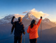
Most visitors come to this region for the mountains, and understandably so: the Annapurna massif itself, the deeply sacred and visually overwhelming Machhapuchhre, the close-up intimacy of the Annapurna Sanctuary, and the high passes of the classic circuit trek have made this corner of Nepal one of the most celebrated trekking destinations on earth.
But the conservation area that contains all of this — the legal, ecological, and social structure that has allowed these mountains to remain wild, these forests to remain standing, and these communities to remain intact through four decades of exponential tourism growth — deserves to be understood in its own right. It is not simply a backdrop to the trekking routes that pass through it. It is one of the most important and most studied experiments in how human beings might live alongside, rather than apart from, a fragile natural world.
This is a longer and more discursive piece than most of the route guides in our blog series, and deliberately so. The Annapurna Conservation Area rewards a slower kind of attention — a willingness to sit with its history, its biology, its human geography, and its genuinely innovative governance model — before ever lacing up a boot or boarding a jeep. Nepal Vehicle Hiring Pvt Ltd has spent years transporting travelers into every corner of this remarkable landscape, and what follows is our attempt to convey not just the practical facts a visitor needs, but something closer to a real understanding of the place itself.
A Conservation Area Unlike Any Other in Nepal
To understand why the Annapurna Conservation Area matters, it helps to understand what came before it. Nepal’s first protected areas — Chitwan National Park, established in 1973, and Sagarmatha (Everest) National Park, established in 1976 — followed a conservation philosophy imported largely from the Western world: draw a boundary around a wilderness, restrict or remove human settlement and resource use within it, and place the entire area under the strict, often paramilitary, control of a government park authority.
This model, sometimes described by conservation scholars as ‘fortress conservation,’ had real successes in Nepal, particularly in protecting megafauna such as the Bengal tiger and the greater one-horned rhinoceros in the lowland Terai. But it carried a deep and often unacknowledged cost: the people who had lived within or adjacent to these landscapes for generations, and whose traditional land-use practices had often shaped the very ecosystems being protected, were treated as a problem to be managed rather than a resource to be engaged.
By the mid-1980s, conservationists working in Nepal — and a small, determined group of Nepali biologists and social scientists in particular, among them the influential figure of Dr. Chandra Prasad Gurung, who would become one of the architects of the new approach — had begun to question whether this model could ever work in the Annapurna region.
The reasons were practical as much as philosophical. The proposed conservation area was already home to well over one hundred thousand people, spread across dozens of villages practicing subsistence agriculture, herding, and an increasingly important trekking-tourism economy that had grown rapidly since Nepal first opened to foreign trekkers in the 1960s. There was, quite simply, no realistic way to evacuate or radically restrict the activity of this population without provoking the kind of resistance, resentment, and ultimately failure that had already begun to characterize more rigid conservation efforts elsewhere in the world.
The solution that emerged — formalized with the establishment of the Annapurna Conservation Area in 1986 under the newly created King Mahendra Trust for Nature Conservation (the organization now known as the National Trust for Nature Conservation, or NTNC) — was something genuinely new in the history of Nepali conservation, and indeed in the history of protected area management more broadly.
Rather than a government department staffed by uniformed park rangers enforcing exclusion, the Annapurna Conservation Area Project, or ACAP, was designed from its inception as a bottom-up, community-managed conservation initiative. Local people were not treated as obstacles to conservation; they were deliberately and structurally positioned as its primary agents and beneficiaries.
The Architecture of Community-Based Conservation
It would be a mistake to romanticize this model into something simpler or more idealistic than it actually is. ACAP’s governance structure is a carefully engineered system of incentives, institutions, and revenue flows, refined over nearly four decades of practical experience, occasional failure, and continuous adjustment.
At its foundation lies the Integrated Conservation and Development Program, or ICDP — an approach that explicitly links environmental protection to tangible improvements in local livelihoods, on the theory (now well supported by the region’s own track record) that conservation succeeds most durably when the people living closest to a resource have a direct and visible stake in its long-term health.
In practical terms, this has meant that ACAP’s activities extend far beyond wildlife monitoring and forest patrols. The project has invested heavily in alternative and renewable energy infrastructure — back-boiler water heating systems, improved cooking stoves, and micro-hydroelectric installations — specifically designed to reduce the immense pressure that a rapidly growing trekking-lodge industry was placing on the region’s forests for firewood. It has run extensive programs in women’s empowerment and community health, recognizing that conservation outcomes are inseparable from the broader social wellbeing of the communities responsible for delivering them.
It has supported the formation of community forest user groups that hold genuine decision-making authority over the management of their local forest resources, rather than simply receiving instructions from a central authority. And it has built and maintained the extensive network of trails, bridges, and basic infrastructure that today allows a trekker to walk for weeks across the Annapurna region while rarely being more than a few hours from a teahouse offering a hot meal and a roof — an infrastructure achievement that itself depends on continuous, locally rooted maintenance.
The financial architecture underpinning all of this is, in its own way, as significant as the conservation philosophy itself. Unlike most of Nepal’s national parks, which depend substantially on government budget allocations, ACAP is almost entirely self-financing, funded by entry permit fees paid by trekkers and travelers who pass through the conservation area each year. This creates a direct and continuously renewing link between the volume and value of tourism in the region and the resources available for its conservation — a relationship that, when it works well, aligns the economic interests of the tourism industry with the ecological health of the landscape that sustains it.
The governance structure divides the conservation area into seven Unit Conservation Offices — three in the trans-Himalayan north, at Jomsom, Manang, and Lo Manthang, and four on the wetter southern flank of the Annapurna massif, at Ghandruk, Sikles, Bhujung, and Lwang — each responsible for coordinating conservation and development activity within its own portion of this vast and ecologically varied territory.
None of this has been without friction. Scholars who have studied ACAP closely over the decades have documented genuine tensions: disputes over the equitable distribution of tourism revenue between villages with heavy trekker traffic and those with little; debates over how much authority should rest with the central NTNC organisation versus increasingly empowered local conservation area management committees; and the ongoing, unresolved challenge of managing a tourism economy that, in its most successful corridors, now generates pressures — on waste management, on water resources, on traditional architecture and ways of life — that the original 1986 framework could not fully have anticipated.
But by the broad measure that matters most in conservation — whether the forests, the wildlife, and the communities of the Annapurna region remain intact and viable four decades later — the model has worked, and worked well enough that NTNC has since exported variations of the same approach to the Manaslu and Gaurishankar conservation areas elsewhere in Nepal.

Annapurna-Range
A Landscape That Defies Easy Description
The sheer physical range of the Annapurna Conservation Area is difficult to convey without sounding like an exaggeration. Within its 7,629 square kilometres — spread across the districts of Manang, Mustang, Kaski, Myagdi, and Lamjung — the land rises from roughly 760 metres above sea level in the warm, paddy-terraced foothills near Besisahar and Nayapul, through dense subtropical and then temperate forest, through the rhododendron and oak belt that gives the region’s mid-hills their characteristic spring colour, through high alpine pasture grazed by yak and blue sheep, and finally into the stark, wind-scoured, almost lunar high-altitude desert of the trans-Himalayan Mustang valley, before culminating at the 8,091-metre summit of Annapurna I itself — the world’s tenth-highest mountain and, statistically, one of the most dangerous 8,000-metre peaks ever attempted by mountaineers.
This vertical compression of nearly every climatic zone found on earth, from subtropical to high-altitude desert to permanent snow and ice, all within a horizontal distance that a determined traveler can cross in a matter of days, is the single most important fact about the Annapurna region’s ecology. It means that biodiversity here is not distributed evenly across the landscape but stacked in dramatic, telescoping bands of altitude — and it means that a single multi-week trek through the conservation area can expose a walker to a greater range of distinct ecosystems than an equivalent journey almost anywhere else on the planet.
At the heart of this landscape runs the Kali Gandaki River, which has carved what is generally described as the deepest river gorge on earth — a measurement based not on the simple depth of the river channel itself, but on the vertical distance between the riverbed and the summits of the two great mountains that flank it on either side: Dhaulagiri, at 8,167 metres, to the west, and Annapurna I, at 8,091 metres, to the east. The vertical relief between the Kali Gandaki’s waters and these two summits exceeds 5,500 meters in places — a scale of landscape that is genuinely difficult for the human eye and mind to process even when standing directly within it.
Geologically, the gorge is also a window into deep time: its exposed rock layers contain marine fossils, including the black ammonite stones known locally as Shaligrams and revered by Hindu pilgrims as natural manifestations of Lord Vishnu, dating from the ancient Tethys Sea that once covered this region some sixty million years before the Indian and Eurasian tectonic plates collided and began the slow, ongoing uplift that created the Himalaya.
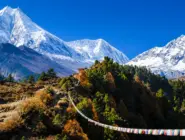
To the east of this central gorge, the Marsyangdi River has carved its own dramatic valley, the corridor along which the classic Annapurna Circuit trek and its associated jeep road now run, climbing from the warm lowlands near Besisahar through a succession of increasingly dramatic gorge sections to the high, arid, Tibetan-influenced valley of Manang.
And tucked into the glacial basin above Manang, reached only after a demanding climb, lies Tilicho Lake — generally described as the highest lake of its size anywhere on earth, a body of intensely blue glacial water sitting at close to 4,920 metres beneath the sheer faces of the Tilicho and Annapurna peaks, in a setting of such stark, silent grandeur that it has become one of the most sought-after extension destinations for trekkers who have already completed the standard circuit.
The Living Forests — Flora of the Conservation Area
More than 1,200 species of flowering plants have been documented within the Annapurna Conservation Area. This figure places this single protected territory among the richest botanical landscapes in the Himalayan world, and indeed among the richest temperate and subtropical floras on earth, given the area’s modest size. This diversity is, again, substantially a product of the region’s extreme altitudinal range: as one climbs from the warm valley floor toward the high passes, plant communities shift in a continuous, overlapping succession of distinct ecological zones, each adapted to its own particular combination of temperature, rainfall, and growing season.
In the lower and middle elevations, particularly on the wetter southern flank of the Annapurna massif facing the monsoon winds rising from the Indian Ocean, dense forests of sal, oak, and chestnut give way with increasing altitude to magnificent stands of rhododendron — and it is here, around the village of Ghorepani on the approach to the celebrated Poon Hill viewpoint, that the conservation area contains what is frequently described as the largest contiguous rhododendron forest in the world.
Thirty-eight distinct species of rhododendron have been recorded within the Annapurna Conservation Area, ranging from low shrubs to towering forest trees, and when this extraordinary diversity bursts into bloom each spring — typically across March and April, in a cascading sequence as different species and different altitudes reach their flowering peak at slightly different moments — the hillsides above Ghorepani and across much of the lower Annapurna region turn through successive waves of white, pink, deep red, and occasionally yellow blossom that constitute one of the great floral spectacles of the entire Himalayan world. The rhododendron, known in Nepali as lali gurans, is Nepal’s national flower, and nowhere in the country is its diversity and abundance more visible than within this conservation area.
Above the rhododendron and oak belt, forests of birch, fir, and hemlock give way in turn to high alpine meadow and scrub, dotted in the brief summer growing season with a remarkable diversity of high-altitude wildflowers, many of them used in traditional medicine by local communities and increasingly studied by botanists and pharmacologists for their potential medicinal properties. And in the driest, highest, most exposed reaches of the trans-Himalayan north — the Mustang and upper Manang valleys, lying in the rain shadow cast by the Annapurna and Dhaulagiri massifs to their south — vegetation thins to the hardy, drought-adapted shrubs and grasses characteristic of high-altitude desert, interrupted by the carefully irrigated barley fields, apple orchards, and poplar groves that local communities have cultivated for centuries in the narrow, fertile pockets where mountain streams reach the valley floor.

The Wild Inhabitants — Fauna of the Annapurna Region
The same altitudinal compression that produces the conservation area’s extraordinary plant diversity also supports an equally remarkable range of animal life, much of it rare, elusive, and of significant global conservation concern. Somewhere in the region’s higher, more remote crags and ridgelines, at altitudes generally above 3,000 metres, moves the snow leopard — perhaps the single most iconic and most rarely seen large mammal in the entire Himalayan range, an apex predator so superbly adapted to its harsh, rocky, high-altitude environment, and so naturally elusive in its behaviour, that even researchers who have spent years studying the species through camera-trap surveys and tracking studies consider a direct sighting to be a matter of exceptional fortune rather than routine observation.
The protection of viable snow leopard habitat and prey populations — principally blue sheep and Himalayan tahr, the wild goat-antelope species that share the highest reaches of the conservation area with the great cat that hunts them — has been a consistent conservation priority of the ACAP program since its inception.
At slightly lower elevations, in the dense temperate forests of the conservation area’s middle altitudes, lives the red panda — a species entirely unrelated, despite the shared name, to the giant panda of China, but equally distinctive in appearance, with rich rust-red fur, a long bushy tail, and an almost entirely bamboo-based diet that makes it acutely vulnerable to the loss or degradation of its specific forest habitat.
The red panda’s endangered status and its particular sensitivity to forest disturbance have made it something of a flagship species for ACAP’s broader forest conservation efforts, a visible and charismatic symbol of the stakes involved in protecting the temperate forest belt on which the species depends.
Beyond these two headline species, the conservation area supports musk deer (hunted historically, and still occasionally illegally, for the valuable musk gland prized in traditional medicine and perfumery), Himalayan black bear, grey wolf, several species of langur monkey, and a long list of smaller mammals that together constitute a recorded mammalian fauna of roughly one hundred species. The bird life is, if anything, even more remarkable in its diversity: more than four hundred and fifty species have been documented within the conservation area’s boundaries, including the spectacular Impeyan monal — known locally as the Danphe, and recognized as Nepal’s national bird — whose iridescent, multi-coloured plumage makes it one of the most visually striking pheasants anywhere in the world.
Birders are also drawn to the conservation area for its impressive raptor population, including the lammergeier, or bearded vulture, a huge, distinctively marked scavenger that specializes in feeding on bone marrow extracted from carcasses dropped from height onto rocks below, and the Himalayan griffon vulture, whose enormous wingspan and effortless thermal-riding flight are a familiar sight above the region’s high ridgelines.
The conservation area’s herpetofauna — its reptiles and amphibians — receives considerably less popular attention than its mammals and birds, but remains scientifically significant: roughly forty reptile species and just over twenty amphibian species have been recorded, many of them adapted to the specific ecological niches created by the region’s extreme altitudinal range, including several species found at elevations that would be considered extraordinary for reptiles or amphibians almost anywhere else in the world.

A Mosaic of Peoples Within a Single Conservation Boundary
Perhaps the most distinctive feature of the Annapurna Conservation Area, when set against most of the world’s other major protected landscapes, is simply the number and diversity of people who call it home. More than one hundred thousand permanent residents live within the conservation area’s boundaries, distributed across several dozen villages and belonging to a range of distinct ethnic and linguistic communities whose presence in this landscape, in several cases, considerably predates the arrival of the conservation area itself, and indeed predates the modern Nepali state.
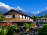
On the wetter, more populous southern flank of the Annapurna massif, Gurung and Magar communities have farmed the steep terraced hillsides for generations, supplementing subsistence agriculture with a long and historically significant tradition of military service — first with the British and Indian Gurkha regiments, and subsequently with the Nepal Army itself — that has profoundly shaped the economic and social structure of villages such as Ghandruk and Sikles, both of which today also serve as important trekking hubs and conservation area unit office locations.
Moving north and west into the higher, drier valleys, the cultural character shifts noticeably: the Thakali people of the Kali Gandaki valley, historically the controllers of the lucrative trans-Himalayan salt trade between Tibet and the Indian plains, have built a reputation for both commercial acumen and culinary sophistication that extends well beyond their home region, while the Manangi people of the upper Marsyangdi valley around Manang village have likewise developed a distinctive trading tradition, taking advantage of historical trade privileges to build successful business networks that, in recent decades, have extended as far as international trading operations.
At the conservation area’s far northern edge, in the high-altitude desert valley of Upper Mustang, the Lhopa or Loba people maintain what is widely regarded as one of the most intact surviving examples of traditional Tibetan culture anywhere in the world — more continuous, in important respects, than what survives within Tibet itself, where decades of disruption under Chinese rule have severed many traditional religious and social structures that remain living practice in and around the walled medieval city of Lo Manthang. And interspersed among these distinct indigenous and trading communities are Hindu hill-caste Brahmin and Chhetri populations, settled across various parts of the conservation area, adding yet another layer to an already remarkably complex social landscape.
This human diversity is not incidental to the conservation area’s identity; it is, in many respects, central to it. ACAP’s founding insistence on community-based management was only possible because these communities already possessed their own traditions of collective resource management, local decision-making, and adaptation to a genuinely difficult mountain environment — traditions that the conservation project sought to recognize, formalize, and support, rather than displace with an imported bureaucratic alternative.
The conservation area’s various unit conservation offices, deliberately distributed to reflect this underlying cultural geography, function as much as cultural as ecological administrative units, each calibrated to the specific community structures and traditional governance practices of the populations they serve.

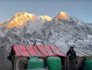
Tourism, Trekking, and the Trail Network
It is impossible to discuss the Annapurna Conservation Area today without addressing its standing as one of the most celebrated trekking destinations on earth — a reputation the region has built steadily since Nepal first opened to independent foreign trekkers in the 1960s, and which the conservation area’s careful management has, on balance, sustained and even enhanced over the subsequent decades rather than diminished through overexploitation.
Before the global disruption of international travel in 2020, the conservation area was receiving well over one hundred thousand foreign visitors annually, a figure that places it among the most heavily visited single protected areas anywhere in the Himalayan world, and one that led Lonely Planet to rank the broader Annapurna region among its list of the world’s top tourism destinations.
The classic Annapurna Circuit trek — traditionally taking somewhere between fourteen and twenty-one days to complete on foot, circling the entire Annapurna massif via the dramatic Thorong La pass at 5,416 meters — remains the conservation area’s signature long-distance route. However, the extension of jeep roads along significant sections of its lower course, particularly the Marsyangdi corridor between Besisahar and Manang, has fundamentally changed how many modern trekkers approach the journey, often using vehicle transport to cover the lower sections more efficiently before continuing on foot through the higher and more dramatic terrain above Manang.
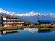
The Annapurna Base Camp trek, leading into the breathtaking glacial amphitheatre of the Annapurna Sanctuary, the shorter and increasingly popular Ghorepani-Poon Hill trek with its celebrated sunrise panorama and rhododendron forests, the steadily growing Mardi Himal trek offering close views of Machhapuchhre from a quieter and less developed trail, and the more demanding, restricted-area Nar Phu Valley trek into one of the conservation area’s most remote and culturally distinct corners together constitute a trail network of remarkable variety, capable of accommodating everything from a casual three-day family excursion to a serious multi-week mountaineering-adjacent expedition.
What makes this trail network function as smoothly as it does — allowing, as conservation researchers studying the area have specifically noted, a trekker to walk for days through genuinely remote high-altitude terrain while rarely being more than a few hours from a warm meal, a clean bed, and basic medical assistance — is the extensive teahouse and lodge infrastructure that local communities, supported by ACAP’s broader development programming, have built up over four decades.
This infrastructure is itself a direct expression of the conservation area’s underlying development philosophy: tourism revenue, rather than being extracted by outside operators and exported from the region, flows substantially to the same local families and communities who are also the conservation area’s primary environmental stewards, creating precisely the alignment of economic and ecological interest that the original 1986 framework was designed to achieve.

Dharapani-treking-start-point-abc
The Unresolved Tensions of Success
No honest account of the Annapurna Conservation Area can avoid acknowledging that its very success has generated new pressures that the original conservation framework continues to grapple with. The extension of motorable jeep roads into the Marsyangdi and lower Kali Gandaki valleys over the past fifteen to twenty years — roads built primarily to serve the everyday transport needs of local communities, but which have also fundamentally altered the trekking economy along the routes they follow — remains a genuinely contested issue, both within local communities and among the broader trekking and conservation community.
For some lodge owners and villages, particularly those bypassed by the new roads, the shift in trekker traffic toward vehicle-accessible alternatives has led to a real decline in foot-traffic-dependent income. For others, the same roads have opened entirely new forms of tourism revenue, including the off-road jeep touring covered in detail elsewhere in our blog series, and have improved access to markets, healthcare, and Education for communities that previously depended on multi-day walks to reach the nearest road.
Climate change presents a less visible but arguably more serious long-term challenge. The glaciers that feed the Marsyangdi, Kali Gandaki, and Modi Khola river systems — and that ultimately sustain the agricultural communities living throughout the conservation area and far downstream beyond its boundaries — are retreating, as they are across the Himalayan range more broadly, with implications for water availability, agricultural patterns, and the frequency of glacial lake outburst flood events that current research suggests will only intensify in the coming decades.
The conservation area’s role as what ecologists term a critical watershed — a function explicitly recognized in its founding rationale, given that the rivers originating within its boundaries ultimately supply water to millions of people living far downstream in Nepal’s mid-hills and Terai plains — makes these climate pressures a concern that extends well beyond the conservation area’s own resident population.
Waste management, particularly the accumulation of non-biodegradable trekking and tourism-related waste along the most heavily trafficked sections of trail, remains an ongoing operational challenge that ACAP and local community organizations continue to address through a combination of permit-funded clean-up initiatives, waste collection infrastructure at major trekking hubs, and increasingly explicit guidance to visitors regarding responsible waste disposal and plastic reduction.
And the broader question of how to manage visitor volume on the most popular routes — balancing the conservation area’s genuine economic dependence on tourism revenue against the carrying capacity of specific trails, villages, and ecosystems — remains a live and unresolved policy question, addressed in recent years through measures including the 2023 regulation mandating licensed guides for foreign trekkers on major routes, a policy intended in part to improve visitor safety and in part to channel a greater share of tourism revenue toward trained local guiding professionals.

Manang Annapurna Ranage
Permits, Fees, and the Mechanics of Visiting
Every visitor entering the Annapurna Conservation Area — whether on foot, by jeep, or by any other means of transport — is required to obtain the Annapurna Conservation Area Permit, generally referred to simply as ACAP, regardless of which specific trail or route they intend to follow, how long they plan to stay, or how high they intend to travel. This permit requirement applies uniformly throughout the conservation area and is checked at numerous entry checkpoints throughout the region, including Birethanti, Jhinu Danda, Chhomrong, Besisahar, and Jomsom.
The permit fee itself, alongside the related TIMS card that many routes also require, constitutes the principal funding mechanism for the entire ACAP conservation and development programme described throughout this article — meaning that every visitor’s permit fee is, quite literally, financing the trail maintenance, forest conservation, wildlife protection, and community development activity that makes their own visit possible in the first place.
| Permit | 2026 Cost (approx.) | Mandatory? | Where Obtained |
| ACAP (Annapurna Conservation Area Permit) | NPR 3,000 (USD 25–30) per person | Yes — without exception, for every route inside the ACA | Nepal Tourism Board, Kathmandu or Pokhara; checked at every entry checkpoint |
| TIMS Card (Trekkers’ Information Management System) | USD 10–20 per person | Enforcement varies by season and route — increasingly expected | Nepal Tourism Board / TAAN office |
| Licensed Guide | USD 25–35 per day | Mandatory since the 2023 regulation for major ACA routes | Arranged through any registered trekking agency |
Beyond the conservation area permit itself, trekkers undertaking the Annapurna Circuit’s extension into the restricted Nar Phu Valley, or continuing beyond Kagbeni into the separately regulated restricted area of Upper Mustang, face additional permit requirements specific to those more tightly controlled zones — reflecting both their particular cultural sensitivity and the Nepali government’s broader policy of managing visitor volume to its most ecologically and culturally fragile border regions.

ghorepani-poon-hill
Why This Landscape Still Matters
It would be easy, faced with the scale of the Annapurna massif itself, to treat the conservation area surrounding it as a mere administrative formality — the paperwork required to access a trekking route, rather than a subject worthy of attention in its own right. But to do so would be to miss something genuinely important about what this particular stretch of the Himalaya represents, both ecologically and as a working model for how protected landscapes everywhere might be managed more humanely and sustainably.
The Annapurna Conservation Area demonstrates, with nearly four decades of accumulated evidence, that conservation and human community do not have to exist in fundamental opposition to one another — that a landscape can sustain extraordinary biodiversity, protect globally significant and endangered species, preserve geological and ecological features of genuine planetary uniqueness, and simultaneously remain home to over a hundred thousand people pursuing their own traditional and evolving ways of life, provided the governance structure connecting conservation and community is designed with sufficient care, humility, and willingness to adapt.
This is not a small or easily replicated achievement. It is the product of sustained institutional commitment, considerable trial and error, and a foundational decision — made by a small group of Nepali conservationists in the mid-1980s, against the dominant conservation orthodoxy of their time — to trust local communities with the stewardship of their own landscape rather than displacing them in the name of its protection.
For the traveler passing through this conservation area, whether on foot along the high passes of the classic circuit, by jeep through the dramatic gorge country of the Marsyangdi and Kali Gandaki valleys, or simply for a few days around the foothill villages near Pokhara, this underlying story is worth carrying alongside the more immediate, more visually overwhelming experience of the mountains themselves. Every permit fee paid, every teahouse meal purchased, every local guide hired contributes, in a very direct and traceable way, to the continuation of an experiment in conservation that has, against considerable odds, succeeded — and that continues to offer genuine lessons for how the rest of the world might think about the relationship between protected landscapes and the people who call them home.
The Conservation Area at a Glance
| Key Fact | Detail |
| Established | 1986 — Nepal’s first conservation area |
| Total Area | 7,629 sq km — Nepal’s largest protected area |
| Districts Covered | Manang, Mustang, Kaski, Myagdi, and Lamjung |
| Managing Body | National Trust for Nature Conservation (NTNC), via the Annapurna Conservation Area Project (ACAP) |
| Resident Population | Over 100,000 people of diverse ethnic and linguistic backgrounds |
| Altitude Range | 760–790 m (subtropical valley floor) to 8,091 m (summit of Annapurna I) |
| Governance Model | Community-based — the first protected area in Nepal managed bottom-up by local people, not a paramilitary park authority. |
| Funding Model | Self-financed almost entirely through visitor entry permit fees, not the government budget |
| Global Recognition | Ranked among the world’s top tourism destinations by Lonely Planet (2020); cited by UNESCO as an exemplary conservation model (2010) |

| Category | Recorded Species (approx.) | Notable Examples |
| Flowering plants | Over 1,200 species | 38 species of rhododendron alone — Nepal’s national flower |
| Mammals | 100–105 species | Snow leopard, red panda, Himalayan tahr, musk deer, Himalayan black bear, grey wolf, blue sheep |
| Birds | 450–520+ species | Impeyan monal (Danphe, Nepal’s national bird), blood pheasant, lammergeier, Himalayan griffon vulture |
| Reptiles | 39–40 species | Various high-altitude and mid-hill lizard and snake species |
| Amphibians | 22–23 species | High-altitude frog and toad species adapted to extreme elevation |
Getting There — A Practical Note from Nepal Vehicle Hiring Pvt Ltd
Reaching the Annapurna Conservation Area, at nearly every one of its many access points, begins with a road journey before any trekking trail is ever reached — and the specific point of entry shapes the entire character of the visit that follows. Travelers heading toward Ghorepani and the famous Poon Hill viewpoint typically begin from Pokhara via Nayapul or Kande; those undertaking the Annapurna Circuit or its Manang extension begin from Besisahar, reached either from Kathmandu or via Pokhara, with the off-road jeep sections beyond Besisahar requiring a genuine 4WD vehicle as described in detail in our dedicated off-road jeep and Besisahar-Manang guides. Those continuing into the trans-Himalayan north toward Jomsom, Muktinath, and Upper Mustang generally travel from Pokhara along the dramatic Kali Gandaki corridor.
Nepal Vehicle Hiring Pvt Ltd provides private vehicle hire — sedan, 4WD Scorpio, Toyota Hilux, and Toyota Land Cruiser, depending on the specific route’s terrain demands — for every one of these access corridors, along with the experienced local drivers, permit guidance, and itinerary knowledge built up over years of operating throughout this conservation area. Whether your interest in the Annapurna Conservation Area is a short cultural excursion to a Gurung village near Pokhara, a full circuit trek requiring careful trailhead logistics, or an extended off-road jeep adventure into Upper Mustang, we are positioned to handle the transport logistics with the same care and attention to detail that this remarkable landscape deserves.
A Model Studied and Exported Far Beyond Annapurna
The influence of the Annapurna Conservation Area’s governance model has, over time, extended well beyond the boundaries of the landscape it was originally designed to protect. Having accumulated more than a decade of operational experience by the late 1990s, NTNC began applying substantially the same Integrated Conservation and Development Program philosophy to the Manaslu region immediately to the east, establishing the Manaslu Conservation Area.
Project with support from the Government of Nepal and the Asian Development Bank — a deliberate act of institutional replication that treated the Annapurna experience not as a one-off success but as a transferable template. A similar logic has since informed the establishment of the Gaurishankar Conservation Area, further east, extending the same basic principle of community-anchored, self-financing, bottom-up conservation governance into yet another of Nepal’s ecologically and culturally significant mountain landscapes.
International conservation researchers and protected-area managers have likewise taken sustained interest in the Annapurna case, treating it as one of the most thoroughly documented examples anywhere in the world of what conservation scholarship sometimes terms ‘community-based natural resource management’ operating at genuine landscape scale, rather than within the smaller, more easily controlled pilot projects through which this approach is more commonly tested.
UNESCO’s 2010 assessment of the Annapurna Conservation Area specifically highlighted its innovative fusion of tourism revenue, community empowerment, and ecological protection as a model relevant well beyond Nepal’s borders. This recognition has, in the years since, drawn conservation delegations and researchers from other Himalayan nations and beyond to study how the model has actually functioned in practice, including its genuine shortcomings as well as its more celebrated successes.
This exported influence matters for how the Annapurna Conservation Area should be understood today. It is not simply a successful local arrangement specific to one set of mountain valleys and one set of communities; it is, in a meaningful sense, a piece of conservation infrastructure that has shaped how an entire generation of Nepali conservation practitioners think about the relationship between protected landscapes and the people who inhabit them. Every subsequent Nepali conservation area established since 1986 has had to reckon, in one way or another, with the precedent set by the Annapurna model — whether by following its example closely, adapting it to different ecological and social circumstances, or consciously departing from it in response to lessons learned along the way.

Dharapani
Frequently Asked Questions — Annapurna Conservation Area
What is the difference between the Annapurna Conservation Area and ACAP?
The Annapurna Conservation Area (ACA) is the protected landscape itself — the 7,629 square kilometer territory spanning five districts. The Annapurna Conservation Area Project (ACAP) is the management program, operated by the National Trust for Nature Conservation, responsible for administering conservation and development activities within that landscape. In everyday usage, the two terms are frequently used interchangeably, though technically one refers to the place and the other to the programme that manages it.
When was the Annapurna Conservation Area established, and why was it significant?
The Annapurna Conservation Area was established in 1986, making it Nepal’s first conservation area and, at 7,629 square kilometers, its largest protected area of any kind. Its significance lies in its pioneering community-based management model — the first protected area in Nepal’s conservation history in which local communities were directly and structurally involved in actual management decisions, rather than being subject to a centrally imposed park authority.
How many people live within the Annapurna Conservation Area?
More than 100,000 permanent residents live within the conservation area’s boundaries, belonging to a wide range of distinct ethnic and linguistic communities including Gurung, Magar, Thakali, Manangi, Lhopa (Loba), and Hindu hill-caste Brahmin and Chhetri populations, among others.
What is the ACAP permit and how much does it cost in 2026?
The Annapurna Conservation Area Permit (ACAP) is the mandatory entry permit required for every visitor to the conservation area, regardless of route or duration. As of 2026, the fee is approximately NPR 3,000 (roughly USD 25-30) for foreign nationals, obtainable from the Nepal Tourism Board offices in Kathmandu or Pokhara, or, in some cases, online through registered trekking agencies.
What wildlife can be found in the Annapurna Conservation Area?
The conservation area supports the snow leopard, red panda, Himalayan tahr, musk deer, Himalayan black bear, grey wolf, and blue sheep among its approximately 100 recorded mammal species, along with over 450 bird species, including the Impeyan monal (Nepal’s national bird), and a smaller but scientifically significant population of reptiles and amphibians adapted to the region’s extreme altitudinal range.
What is the world’s deepest gorge inside the conservation area?
The Kali Gandaki Gorge, carved by the Kali Gandaki River between the Dhaulagiri and Annapurna massifs, is generally recognized as the world’s deepest river gorge when measured by the vertical relief between the riverbed and the flanking summits — a difference exceeding 5,500 meters in places.
Conclusion
The Annapurna Conservation Area is, in the end, two extraordinary things at once: one of the most biologically and geologically remarkable landscapes anywhere on the Himalayan range, and one of the most quietly influential experiments in conservation governance that the modern environmental movement has produced. Its mountains, gorges, forests, and high-altitude deserts would be worth protecting on their own merits.
But it is the deliberate, sustained decision to protect that landscape together with, rather than against, the more than one hundred thousand people who call it home that makes the Annapurna Conservation Area something genuinely instructive — a working demonstration, refined over nearly four decades, that conservation and human community can be made to serve one another rather than compete.
Nepal Vehicle Hiring Pvt Ltd is honored to provide the transport that carries travelers into this landscape — and we hope that, whatever brings you to the Annapurna region — whether the mountains themselves or the deeper story of how this remarkable place has been protected — you leave with a fuller appreciation of both.
Plan your Annapurna region journey — Call or WhatsApp: +977-9851013196
E-mail:[email protected]
For travelers who have completed their trek and are planning to explore Kathmandu, we recommend continuing your journey with our trusted sister companies, Trek Nepal Himalayas and Alpine Luxury Treks. We specialize in organizing a wide range of travel experiences across Nepal, from classic trekking adventures to cultural and wildlife tours.
Our top offerings include iconic journeys such as the Everest Base Camp Trek, immersive Kathmandu sightseeing tours, breathtaking Nagarkot sunrise experiences, exciting Chitwan jungle safaris, and luxury packages. In addition, we can arrange short hikes, heritage tours, mountain flights, and customized travel plans tailored to your schedule and interests.
Whether you are looking for a budget-friendly trip or a luxury trekking experience with premium lodges, private guides, and high-end services, we ensure every detail is professionally managed. Our goal is to provide a seamless transition from your trekking adventure to a comfortable) and a memorable travel experience in Nepal.
- Annapurna Conservation Area: Nepal's Pioneering Model of Community-Led Conservation
- A Conservation Area Unlike Any Other in Nepal
- The Architecture of Community-Based Conservation
- A Landscape That Defies Easy Description
- The Living Forests — Flora of the Conservation Area
- The Wild Inhabitants — Fauna of the Annapurna Region
- A Mosaic of Peoples Within a Single Conservation Boundary
- Tourism, Trekking, and the Trail Network
- The Unresolved Tensions of Success
- Permits, Fees, and the Mechanics of Visiting
- Why This Landscape Still Matters
- The Conservation Area at a Glance
- Getting There — A Practical Note from Nepal Vehicle Hiring Pvt Ltd
- A Model Studied and Exported Far Beyond Annapurna
- Frequently Asked Questions — Annapurna Conservation Area
- Conclusion
Related Blog & Articles
Besisahar to Chame and Upper Pisang Jeep
Kathmandu to Mustang (Muktinath)
Pokhara to Ghorepani Vehicle Transfer
Pokhara to Kande Jeep Price – Complete Transport & Trek Guide 2026-2027
Pokhara to Dhampus Jeep Transfer