Kathmandu to Dhulikhel Car Hire – Private Car Rental for a Perfect Day Trip
Looking for a reliable and affordable car hire from Kathmandu to Dhulikhel? Nepal Vehicle Hiring Pvt Ltd offers the best private car rental service for this popular scenic route — just 32 km east of Kathmandu via the Araniko Highway.
Dhulikhel is a charming hill town in Kavrepalanchok District, sitting at 1,550 meters above sea level. Renowned for its panoramic Himalayan sunrise views, ancient Newari architecture, and proximity to the sacred Namobuddha Monastery and the historic town of Panauti, Dhulikhel is one of the most popular and rewarding day trips from Kathmandu — for locals and international tourists alike.
Whether you plan a sunrise drive, a full-day Dhulikhel–Namobuddha–Panauti tour, or a weekend getaway, hiring a private car from Kathmandu ensures you travel in comfort, on your own schedule, with door-to-door pick-up from your hotel.
Why Hire a Private Car from Kathmandu to Dhulikhel?
Public buses depart from Ratna Park and Koteshwor in Kathmandu and reach Dhulikhel in roughly 1 hour 45 minutes to 2 hours. However, a private car hire delivers a far superior experience:
Faster Journey: A private car covers the 32 km in just 1–1.5 hours, significantly quicker than public buses (1 hr 49 min+).
Hotel Pick-Up & Drop-Off: Your driver collects you from your Thamel, Lazimpat, or Durbar Marg hotel and drops you back — no navigating bus parks or sharing rides.
Sunrise Timing: For the famous Dhulikhel sunrise, departure from Kathmandu must be by 5–5:30 AM. Only a pre-booked private car ensures reliability.
Flexible Stops: Stop at Bhaktapur, Banepa, Sanga (Giant Shiva Statue), or scenic viewpoints along the Araniko Highway at your own pace.
Comfort & Privacy: Ideal for couples on a romantic getaway, families with children, elderly travelers, or groups carrying camera equipment and hiking gear.
Round-Trip Available: Book a full-day car hire and explore Dhulikhel, Namobuddha, and Panauti before returning comfortably to Kathmandu in the evening.
Top Attractions to Visit on Your Dhulikhel Car Hire Trip
Attraction
Highlights
Dhulikhel Sunrise Viewpoint
360° Himalayan panorama: Langtang, Dorje Lakpa, Ganesh Himal, Gaurishankar, Everest on clear days
Namobuddha Monastery
Sacred Buddhist pilgrimage site at 1,750 m with Thrangu Tashi Yangtse Monastery, 12 km from Dhulikhel
Panauti Ancient Town
One of Nepal’s oldest Newari towns, Indreshwar Mahadev Temple, 40+ temples, and the Durbar Square complex
Kali Temple
Hilltop Hindu temple with sweeping valley and Himalayan views, ideal at sunrise and sunset
Old Town Dhulikhel
Traditional Newari architecture, Shiva & Ganesh temples, local bazaar, medieval courtyards
Dhulikhel–Namobuddha Hike
10 km trail through forests, terraced fields, and Newari villages; approx. 4 hours one-way
1. Dhulikhel Sunrise Viewpoint
The main reason most visitors hire a car in Dhulikhel is the breathtaking Himalayan sunrise. From the ridge viewpoints above the town, on a clear morning, you can see a magnificent sweep of snow-capped peaks — Langtang Lirung, Dorje Lakpa, Ganesh Himal, and Gaurishankar — and, on the clearest days, a distant glimpse of Mount Everest to the east. The golden light painting the peaks at dawn is one of the most awe-inspiring sights near Kathmandu.
2. Namobuddha Monastery
Located 12 km south of Dhulikhel at an elevation of 1,750 m, Namobuddha is one of the holiest Buddhist pilgrimage sites in Nepal and the Himalayan world. The hilltop is home to the magnificent Thrangu Tashi Yangtse Monastery — a Karma Kagyu tradition Tibetan Buddhist monastery that doubles as a school for novice monks. According to legend, this is the sacred spot where the Bodhisattva Prince Mahasattva, in a past life, gave his own flesh to save a starving tigress and her cubs — the ultimate act of compassion. The monastery offers 360-degree views of Himalayan peaks and verdant valleys.
3. Panauti Ancient Newari Town
Just 32 km from Kathmandu, Panauti is one of Nepal’s oldest and best-preserved Newari towns, sitting at the confluence of the Roshi and Punyamati rivers at 1,340 m. The town is home to over 40 temples and shrines, including the magnificent 15th-century Indreshwar Mahadev Temple, Bhadrakali Temple, Panauti Durbar Square, and the Panauti Museum. Its brick-paved lanes, traditional courtyard architecture, and colorful festivals make it a living heritage site that rewards leisurely exploration.
4. Old Town Dhulikhel & Temples
Dhulikhel’s Old Town is a beautifully preserved Newari settlement with cobbled lanes, traditional timber-framed houses, and ancient courtyards. Key temples to visit include the Kali Temple, Shiva Temple, Ganesh Temple, Chandeshwori Temple, and Bhagwati Shiva Temple. The Kali Temple hilltop is a particularly fine viewpoint for both sunrise and sunset over the valley.
5. Dhulikhel to Namobuddha Hiking Trail
For travelers combining a car hire with hiking, the Dhulikhel–Namobuddha–Panauti trail is one of the finest day hikes near Kathmandu. The trail covers approximately 10–12 km through forests, terraced rice fields, orange farms, and traditional Newari villages, reaching the Namobuddha hilltop in about 4 hours. After visiting the monastery, trekkers descend to Panauti (2.5 hours), where the private car awaits to return to Kathmandu.
Kathmandu to Dhulikhel – Scenic Stops Along the Araniko Highway
The drive from Kathmandu to Dhulikhel via the Araniko Highway passes through some of Kathmandu Valley’s most scenic and historically rich areas. Your driver can stop at these key points on request:
Sanga (Giant Shiva Statue): Located on the Araniko Highway en route to Dhulikhel, the enormous Kailashnath Mahadev statue — one of the tallest Shiva statues in the world — is a striking roadside landmark and photo stop.
Bhaktapur (optional): The medieval Newari city of Bhaktapur is just 15 km from Kathmandu and a UNESCO World Heritage Site. Ask your driver to include a stop in Bhaktapur for a richer cultural day trip.
Banepa: A bustling market town 27 km from Kathmandu at the junction of the Araniko and BP Highways. A common tea-and-snack stop before reaching Dhulikhel.
Dhulikhel Hilltop Viewpoints: Multiple roadside viewpoints on the approach to Dhulikhel offer excellent Himalayan panoramas — your driver knows the best spots.
Our Car Hire Fleet for Kathmandu to Dhulikhel
Nepal Vehicle Hiring provides well-maintained, comfortable vehicles for the Kathmandu–Dhulikhel route. Choose from our fleet based on your group size and preference:
Sedan / Hatchback Car: Ideal for 1–4 passengers for a comfortable private day trip to Dhulikhel.
SUV / Jeep (Scorpio, Bolero): Perfect for 4–6 passengers, couples, or those wanting a higher-clearance, more comfortable ride. Great if extending the trip to off-road areas. See our Jeep Hire page.
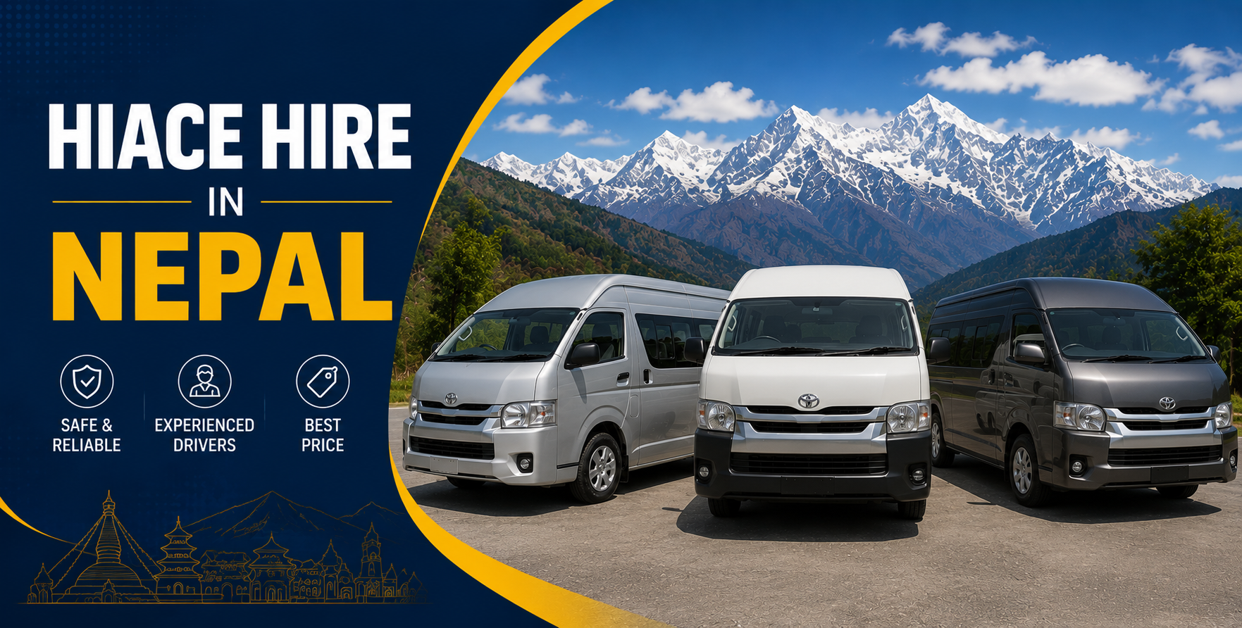
Hiace Van (8–13 passengers): Ideal for family groups, school day trips, and medium-sized tour parties. View Hiace Van Hire.
Coaster / Mini Bus (20–25 passengers): Best for large groups, corporate excursions, and college trips. See our Coaster Hire
All vehicles include a professional, licensed driver. Air conditioning is standard. Fuel and parking are included in your hire rate.
Best Time to Visit Dhulikhel
Autumn (Oct – Nov): The best season. Crystal-clear skies deliver the sharpest Himalayan views. Ideal for sunrise trips and Namobuddha hikes.
Spring (Mar – May): Warm and pleasant with good visibility. Rhododendrons bloom along the hiking trails to Namobuddha.
Winter (Dec – Feb): Cold mornings but excellent mountain clarity. Sunrise from Dhulikhel in winter is spectacular on a clear day.
Monsoon (Jun – Sep): Lush green scenery, but mountain views are largely obscured by clouds. Road conditions remain good on the Araniko Highway.
Step 2: Call / WhatsApp +977 9851013196 with your travel date, pick-up time, hotel location, and any stops you’d like (Namobuddha, Panauti, Bhaktapur, etc.).
Step 3: Receive a confirmed booking with driver details and exact pick-up time.
Step 4: Your driver arrives at your hotel on time and takes you to Dhulikhel — and back — on your schedule.
Related Vehicle Hire Services – Nepal Vehicle Hiring
Sunrise Timing: Depart Kathmandu by 5:00–5:30 AM to reach Dhulikhel viewpoints before sunrise (typically around 6:00–6:30 AM).
Best Months: October, November, March, and April offer the clearest mountain views. Avoid the monsoon (June–September) for sunrise trips.
Combine Destinations: A full-day car hire allows you to cover Dhulikhel + Namobuddha + Panauti in a single comfortable day — roughly 7–8 hours total.
Carry Layers: Dhulikhel mornings are cool (especially October–February). A light jacket or fleece is essential for the sunrise viewpoint.
Camera & Binoculars: Bring a good camera and binoculars for the Himalayan panorama. Early morning light is the most spectacular.
Frequently Asked Questions (FAQs) – Kathmandu to Dhulikhel Car Hire
How far is Kathmandu from Dhulikhel?
The road distance from Kathmandu to Dhulikhel is approximately 32 km via the Araniko Highway. By private car, it takes 1 to 1.5 hours, depending on traffic.
Can I hire a car from Kathmandu to Dhulikhel for a sunrise trip?
Yes — a sunrise trip is one of the most popular reasons to hire a private car to Dhulikhel. Your driver will depart from your Kathmandu hotel between 5:00 and 5:30 AM to reach the viewpoints before first light. Book in advance to guarantee your vehicle for an early departure.
Is Dhulikhel a good day trip from Kathmandu?
Absolutely. Dhulikhel is one of the top day-trip destinations from Kathmandu, offering stunning Himalayan views, rich Newari culture, excellent hiking trails to Namobuddha, and the historic town of Panauti — all within a 32 km drive.
Can I combine Dhulikhel, Namobuddha, and Panauti into a single car hire trip?
Yes. This is one of our most popular full-day itineraries. Drive to Dhulikhel (1 hr), then hike or drive to Namobuddha Monastery (30 min drive / 4 hr hike), then visit the ancient town of Panauti (30 min drive from Namobuddha) before returning to Kathmandu in the evening. Total day: 7–9 hours.
Does Nepal Vehicle Hiring include a driver with the car hire?
Yes. All our car hires include a professional, licensed, and experienced driver who is familiar with the Araniko Highway, Dhulikhel viewpoints, and nearby attractions. The driver also serves as a helpful local guide during your trip.
What is included in the car hire price?
Our Kathmandu-to-Dhulikhel car hire includes driver, fuel, vehicle, and parking fees. Entrance fees (e.g., Namobuddha trail permit, Panauti heritage entry) and meals are not included and are paid separately.
Book Your Kathmandu to Dhulikhel Car Hire Today
Whether it is a solo sunrise escape, a romantic day trip for two, or a family outing combining Himalayan views with cultural heritage, Nepal Vehicle Hiring Pvt Ltd makes your car hire in Dhulikhel seamless and memorable.
Our professional drivers, modern fleet, 24/7 availability, and competitive pricing ensure you spend your time enjoying Dhulikhel — not worrying about transport.
Chitwan to Kathmandu Luxury Car Rental – Private Transfers from Chitwan National Park
Your Chitwan safari is over – the tiger sightings, rhino encounters, and jungle walks are fresh in your memory. Now it is time to travel back to Kathmandu in the style and comfort you deserve. Nepal Vehicle Hiring Pvt Ltd offers the best luxury car rental service from Chitwan to Kathmandu – a smooth, private, door-to-door transfer covering approximately 150-175 km via the scenic Prithvi Highway in 4 to 6 hours.
Whether you are a couple returning from a luxury jungle resort in Sauraha, a family completing the Nepal Golden Triangle tour (Kathmandu-Chitwan-Pokhara), or a corporate traveler on a tight schedule, our private luxury cars, SUVs, and Toyota Land Cruisers provide an unmatched level of comfort, reliability, and professionalism for your return journey.
Our drivers are experienced on the Prithvi Highway, English-communicative, and dedicated to ensuring your post-safari journey is as enjoyable as the wildlife experience itself.
Why Choose a Luxury Private Car from Chitwan to Kathmandu?
Tourist buses cover the Chitwan-Kathmandu route, but a luxury private car rental delivers a completely superior experience in every way:
Resort Pick-Up: Your driver collects you directly from your Sauraha resort or hotel – no walking to bus parks in the Terai heat.
Air-Conditioned Comfort: Chitwan’s subtropical climate is intensely hot. Our luxury AC vehicles maintain a cool, relaxing interior throughout the full 4-6 hour journey.
Direct, Non-Stop Transfer: Travel straight from your Chitwan resort to your Kathmandu hotel, Thamel guesthouse, or Tribhuvan International Airport – one vehicle, zero connections, zero waiting.
Premium Fleet: Choose from luxury sedans, SUVs, and Toyota Land Cruiser 4WD vehicles – the finest private cars available on the Nepal highway network.
Professional, Vetted Drivers: All our drivers are licensed, highly experienced on the Prithvi Highway, and fully vetted for guest safety and professionalism.
Flexible Scenic Stops: Pause at the famous Mugling fish restaurants, the Trishuli River viewpoint, or the Manakamana Cable Car station at your own pace – no fixed bus timetable.
Flight-Time Reliability: Especially critical for guests with onward flights from Kathmandu. Our drivers monitor timing and select the optimal route to ensure you reach the airport safely and on schedule.
Luxury Vehicle Options – Chitwan to Kathmandu
Nepal Vehicle Hiring offers a premium, well-maintained fleet for luxury transfers between Chitwan and Kathmandu. Select the vehicle that matches your group size and comfort preference:
For guests seeking the very best on the Chitwan-Kathmandu route, the Toyota Land Cruiser 4WD is unrivaled. Spacious leather seating, superior suspension that smooths out highway undulations, powerful climate control, and an immaculate professional driver combine to deliver a true VIP private transfer experience. The Land Cruiser is the preferred choice for honeymooners, VIP guests, and business executives. See our Jeep and Land Cruiser hire.
Our luxury sedans and SUVs offer an excellent balance of style, comfort, and value for couples and families with up to 5 passengers. Fully air-conditioned, regularly serviced, and driven by professional chauffeurs, these are the most popular choice for post-safari returns to Kathmandu.
Traveling as a group? Our Toyota Hiace (8-13 passengers) and Coaster (20-25 passengers) provide the most comfortable large-group transfers on this route – reclining seats, air conditioning, ample luggage space, and experienced highway drivers. View Hiace Van Hire and Coaster Hire.
Chitwan to Kathmandu – Scenic Route Highlights
The return drive from Chitwan to Kathmandu via the Prithvi Highway is a journey through some of Nepal’s most beautiful landscapes. These are the key highlights your driver can stop at on request:
Stop / Landmark
Distance from Chitwan & Highlights
Narayanghat
30 km | Busy junction town; fuel stop and snack break on the Narayani River
Mugling Bazaar
100 km | Famous for fresh fish restaurants by the Trishuli River; popular breakfast/lunch stop
Trishuli River Gorge
100-130 km | Dramatic river gorge with white-water rafting views along the Prithvi Highway
Manakamana Cable Car
130 km | Optional stop: cable car to the hilltop Manakamana Devi Temple (1.5-2 hrs)
Naubise & Thankot
145-160 km | Gateway to Kathmandu Valley; winding hill ascent with spectacular valley views
Mugling – The Prithvi Highway’s Famous Fish Stop
Sitting at the confluence of the Trishuli and Marsyangdi rivers roughly halfway along the route, Mugling Bazaar is legendary among Nepali road travelers for its freshwater fish restaurants. Stopping for a plate of freshly grilled Asla (snow trout) with mustard and cumin is a beloved Prithvi Highway tradition. Your driver will happily arrange this classic mid-journey meal break.
Trishuli River Gorge – Nepal’s Scenic Highway Jewel
For much of the Prithvi Highway between Mugling and Naubise, the road runs alongside the dramatic Trishuli River gorge – offering passengers sweeping views of white-water rapids, forested hillsides, and traditional riverside villages. On clear days, Himalayan peaks shimmer above the valley ridgelines in an extraordinary setting of natural beauty.
Manakamana Cable Car – Optional Pilgrimage Stop
Above the Trishuli gorge, the Manakamana Temple cable car rises 1,300 m to a hilltop temple dedicated to the wish-fulfilling Goddess Bhagwati. One of Nepal’s most-visited pilgrimage sites, it can be incorporated as a 1.5-2-hour optional stop on your luxury car hire itinerary. Please request this when booking.
Who Is This Luxury Car Hire Perfect For?
Post-Safari Travelers: After 2-3 days of Chitwan jungle safari, a private luxury car is the ideal way to unwind on the return journey to Kathmandu.
Honeymooners and Couples: A private, air-conditioned luxury car with a professional driver offers a romantic, intimate return from Chitwan’s jungle lodges.
Nepal Golden Triangle Tourists: Completing Kathmandu-Chitwan-Pokhara? Our luxury car hire connects all three destinations with seamless, comfortable private transfers.
Business and Corporate Travelers: For executives on incentive tours or corporate wildlife retreats, our premium vehicles and punctual drivers ensure a smooth, professional transfer.
Airport Connections: For guests with onward flights from Tribhuvan International Airport, our reliable luxury transfer with time monitoring ensures you never miss a flight.
Senior Travelers and Families: The safety, door-to-door comfort, and convenience of a luxury private car are far superior to those of tourist buses for elderly guests and families with young children.
Travel Tips for Your Chitwan to Kathmandu Journey
Depart Early: Leave Sauraha between 7:00 and 8:00 AM to avoid the Kathmandu Valley evening traffic and enjoy the Prithvi Highway in beautiful morning light.
For Airport Transfers: Allow at least 5-6 hours from Sauraha to Tribhuvan Airport. Book your departure at least 6+ hours before your flight, accounting for potential Kathmandu approach traffic.
Book 24 Hours Ahead: While last-minute bookings are accepted, reserving your luxury vehicle at least one day in advance guarantees your preferred class – especially for Land Cruiser 4WD availability.
Pack the Night Before: Have all luggage ready the evening before for a smooth, relaxed early morning departure from your Chitwan resort.
Warm Layers for Kathmandu: Chitwan’s warm Terai climate contrasts with Kathmandu’s cooler temperatures, especially from October to February. Pack a jacket for the arrival in the valley.
How to Book Your Chitwan to Kathmandu Luxury Car Rental
Step 1: Visit com and browse our luxury vehicle options.
Step 2: Call or WhatsApp+977 9851013196 with your travel date, chosen vehicle, passenger count, resort name in Sauraha, and drop-off destination in Kathmandu.
Step 3: Receive your booking confirmation with the driver’s name and exact resort arrival time.
Step 4: Your driver arrives at your Chitwan resort, assists with luggage, and transfers you to Kathmandu in luxury and comfort.
Related Vehicle Hire Services – Nepal Vehicle Hiring
Frequently Asked Questions – Chitwan to Kathmandu Luxury Car Rental
How far is Chitwan from Kathmandu by road?
The road distance from Chitwan (Sauraha) to Kathmandu is approximately 150-175 km via the Prithvi Highway, depending on your exact pick-up point in Chitwan and your destination in Kathmandu.
How long does the drive from Chitwan to Kathmandu take?
A private luxury car takes approximately 4-6 hours, depending on traffic (particularly when approaching the Kathmandu Valley) and any scenic stops along the route. Tourist buses typically take 6-7 hours.
What is the most luxurious vehicle available for this route?
The Toyota Land Cruiser 4WD is our premium vehicle for the Chitwan-Kathmandu route, offering spacious leather seating, top-tier air conditioning, and superior ride quality on the winding Prithvi Highway.
Can I be picked up directly from my resort in Sauraha?
Yes, absolutely. Our drivers travel directly to your resort or hotel anywhere in Sauraha or the Chitwan area for pick-up. There is no need to travel to a bus park or shared taxi stand.
Can I stop at Manakamana Temple during the journey?
Yes. A stop at the Manakamana Cable Car and Temple can be included on request, adding approximately 1.5-2 hours to your journey. Please inform us at the time of booking so we can schedule your departure from Chitwan accordingly.
What is included in the luxury car hire price?
Our hire rate includes the vehicle, professional driver, fuel, and parking charges. Personal expenses, meals, entrance or cable car fees, and driver gratuities are not included. A full transparent quote is provided before confirmation.
Book Your Chitwan to Kathmandu Luxury Car Rental Today
End your Chitwan National Park experience exactly as it deserves – in a luxury private car, with a professional driver, cool air conditioning, and the spectacular Prithvi Highway scenery rolling past your window. Nepal Vehicle Hiring Pvt Ltd makes your return from Chitwan to Kathmandu as memorable as the safari itself.
With 24/7 availability, direct resort pick-up, a premium fleet of luxury vehicles, and years of trusted service across Nepal, we are the first choice for post-safari luxury transfers.
Kathmandu to Lumbini Vehicle – Complete Hiring Guide 2026
Lumbini – the birthplace of Lord Siddhartha Gautama, the founder of Buddhism – is one of the most spiritually significant destinations on earth and a UNESCO World Heritage Site visited by millions of pilgrims and travelers from across the globe every year. Located in the southwestern Terai plains of Nepal, approximately 280 to 300 km from Kathmandu, Lumbini is best reached by hiring a private vehicle – giving you comfort, flexibility, and door-to-door service on this long but deeply meaningful journey.
Whether you are traveling as a Hindu or Buddhist pilgrim, a family explorer, a heritage traveler, or part of a large tour group, Vehicle Hiring Nepal has the perfect vehicle for your 2026 journey from Kathmandu to Lumbini. This complete guide covers every vehicle option, the full road route, pricing, travel tips, what to see in Lumbini, and how to book.
Route Overview: Kathmandu to Lumbini
Distance: Approximately 280–300 km by road
Travel Time: 6 to 8 hours by private vehicle, including rest stops
Best Departure: 6:00 to 7:00 AM from Kathmandu to arrive in Lumbini by early afternoon
Altitude Change: From Kathmandu at 1,400 m descending to Lumbini at just 100 m – subtropical Terai lowlands
The Kathmandu to Lumbini road journey is one of Nepal’s most diverse and interesting long-distance drives – beginning in the mountain valley of Kathmandu, descending through the dramatic Trishuli River gorge on the Prithvi Highway, crossing the subtropical Terai plains on the East-West Highway, and finally arriving at the peaceful, flat sacred zone of Lumbini. No section of the journey is dull.
Vehicle Options for Kathmandu to Lumbini 2026
Vehicle Hiring Nepal provides a full range of vehicles for the Kathmandu-to-Lumbini route – from comfortable sedans for solo travelers and couples to large buses for monastery groups and pilgrimage parties. Here is a complete overview:
Sedan Car – Best for Small Groups
A Toyota Corolla, Suzuki Swift, or similar sedan is the ideal vehicle for 1 to 3 passengers making the Kathmandu-to-Lumbini journey. Comfortable, air-conditioned, and economical on fuel for the long Terai highway section. Perfect for couples, solo pilgrims, and small families without excess luggage.
SUV / Jeep – Best for Families and Small Groups
A Toyota Fortuner, Land Cruiser Prado, or similar SUV offers more space, higher ground clearance, and a more comfortable ride for 4 to 6 passengers. The higher seating position provides better views of the passing landscape, and the vehicle handles the full highway route with ease. Ideal for families with children, small trekking groups, and business travelers who need extra luggage space.
Toyota Hiace Van – Best for Groups of 7 to 14
The Toyota Hiace is the most popular vehicle for medium-sized pilgrim groups, school tours, and cultural travel parties traveling from Kathmandu to Lumbini. With seating for up to 14 passengers, the Hiace offers good interior space, air conditioning, and ample luggage storage. The van rides smoothly on the flat Terai highway section and handles the mountain road from Kathmandu comfortably.
Coaster Bus – Best for 15 to 22 Passengers
The Toyota Coaster is a mid-sized bus perfectly suited to larger pilgrim groups, community tours, and organized religious travel parties. With 20 to 22 comfortable seats, A/C, and ample luggage space, the Coaster handles the full Kathmandu-to-Lumbini route efficiently. Buddhist and Hindu pilgrimage organizations widely use it for this sacred journey.
Full-Size Bus – Best for Large Groups
For larger groups of 25 to 45 passengers – monastery delegations, school groups, corporate tours, and large pilgrimage parties – Vehicle Hiring Nepal provides full-size buses with reclining seats, air conditioning, and full luggage holds. The full-size bus is the most economical per-person option for large groups on the long Kathmandu-to-Lumbini route.
Vehicle Hire Prices: Kathmandu to Lumbini 2026
Vehicle Type
Capacity
One-Way Price (USD)
Round Trip (USD)
Best For
Sedan Car
1–3 pax
$100 – $130
$170 – $220
Solo travelers, couples
SUV / Jeep
4–6 pax
$130 – $170
$220 – $280
Families, small groups
Toyota Hiace Van
7–14 pax
$165 – $210
$280 – $350
Pilgrim groups, tours
Coaster Bus
15–22 pax
$210 – $270
$350 – $440
Large pilgrim groups
Full-Size Bus
23–45 pax
$280 – $380
$460 – $600
Monasteries, school tours
All prices include the driver, full fuel cost, and vehicle insurance for the one-way journey from Kathmandu to Lumbini. Round-trip pricing covers the driver staying in Lumbini or Bhairahawa during your visit and returning you to Kathmandu on your chosen departure date. Contact Vehicle Hiring Nepal for an exact 2026 quote based on your travel dates and group size.
Detailed Road Guide: Kathmandu to Lumbini Stage by Stage
The Kathmandu-to-Lumbini journey traverses three distinct road types and landscapes. Here is the complete stage-by-stage breakdown of what to expect:
Stage 1: Kathmandu to Naubise (30 km | 45 min)
Depart your Kathmandu hotel early – 6:00 to 7:00 AM is ideal to avoid peak Kathmandu traffic and complete the hot Terai section in the cooler morning. Exit Kathmandu through Kalanki in the west and climb the Chandragiri foothills before descending to Naubise. This section has winding switchbacks with views back over the Kathmandu Valley. The road is fully paved and in good condition.
Stage 2: Naubise to Mugling (85 km | 1.5 hrs)
This is the most scenic section of the Kathmandu-to-Lumbini journey. The Prithvi Highway follows the dramatic Trishuli River gorge through forested hills and spectacular cliff scenery. The river runs green and fast below the road – a famous white-water rafting destination. Pass through Malekhu, a popular roadside stop known for fresh river fish restaurants and riverside tea shops. Arrive at Mugling – a busy junction town at the confluence of the Trishuli and Marsyangdi rivers – for a recommended tea or snack break.
Stage 3: Mugling to Narayangadh (36 km | 45 min)
From Mugling, the road turns south on the Narayangadh Highway, rapidly descending from the mountain gorge into the subtropical Terai plains. The landscape transforms completely – rice paddies and farmland replace forested gorge walls, the air becomes warmer and more humid, and the Himalayan peaks disappear behind you. Arrive at Narayangadh (Bharatpur) – the provincial capital of Gandaki Province and a large, bustling Terai city. This is the ideal midpoint stop for lunch or refreshments.
Stage 4: Narayangadh to Butwal (90 km | 1.5 hrs)
Join the East-West Highway heading west across the vast, flat Terai agricultural plains. This is the longest and most straightforward section of the journey – a wide, fast highway through rice fields, mustard plantations, sugarcane, and subtropical forest patches. Towns of Sunwal, Triveni, and Rampur mark the way. Butwal is a significant junction city where the Terai highway meets the road heading north into the Palpa hills.
Stage 5: Butwal to Bhairahawa (25 km | 30 min)
From Butwal, head south toward Bhairahawa (officially Siddharthanagar) – the nearest major city to Lumbini. The road is wide and fast. Bhairahawa is the commercial hub of the western Terai with good hotels, restaurants, ATMs, banks, and the newly upgraded Gautam Buddha International Airport. If any members of your group are flying in or out, Bhairahawa is where Vehicle Hiring Nepal can arrange airport transfers.
Stage 6: Bhairahawa to Lumbini (22 km | 30 min)
The final stage from Bhairahawa heads west on a well-paved road through flat agricultural land. As you approach Lumbini, the landscape becomes notably quieter and more peaceful – the sacred zone exerts its own gentle atmosphere even before you arrive. The road leads directly to the main gate of the Lumbini Development Zone. Your driver will take you to your hotel, monastery guest house, or the sacred garden entrance, whichever you have chosen as your base of accommodation.
Distance and Time: Key Milestones
Stop
Distance from Kathmandu
Approx. Time from KTM
Why Stop
Naubise
30 km
45 min
Last Kathmandu valley view, winding road begins
Malekhu
80 km
1.5 hrs
Trishuli riverside – tea and fresh fish stop
Mugling Junction
115 km
2.5 hrs
Midpoint snack/tea – junction for Pokhara vs Lumbini road
Narayangadh
151 km
3.5 hrs
Best lunch stop – last large city before the Terai highway
Butwal
241 km
5 hrs
Tea break – Terai gateway, junction town
Bhairahawa
266 km
5.5 hrs
ATM, fuel, airport transfers, and final city stop
Lumbini
288 km
6–8 hrs
Final destination – Sacred Garden, temples, monasteries
Why Hire a Private Vehicle from Kathmandu to Lumbini?
Many travelers ask whether public transport is an option for the journey from Kathmandu to Lumbini. While local buses exist, private vehicle hire is superior in almost every way for this long-distance pilgrimage route:
Door-to-door service – your vehicle picks you up from your Kathmandu hotel and drops you at your chosen accommodation in Lumbini with no vehicle changes, no waiting at bus stations, and no carrying of heavy bags across crowded terminals
Depart at your chosen time – a 6:00 AM departure from Kathmandu means arriving in Lumbini by 1:00–2:00 PM, giving you a full afternoon to visit the Sacred Garden and begin your pilgrimage. Public transport cannot match this timing.
Air-conditioned comfort across the hot Terai plains – essential in spring and summer when Terai temperatures reach 38–42°C
Full luggage space for pilgrimage offerings, personal bags, camera equipment, and group supplies
Flexibility to stop at meaningful points – the Devghat sacred confluence, Manakamana Temple, or riverside meal breaks at Malekhu – all on your own schedule.
Privacy for pilgrims and families throughout the journey – no strangers, no overcrowding
Significant time saving – private vehicle in 6 to 7 hours vs public transport in 9 to 12 hours with multiple connections
Same driver available for the return journey, any side trips to Tilaurakot or Devghat, and any emergency assistance
Best Time to Travel from Kathmandu to Lumbini
October to February (Best Season)
The dry winter months are the best time for the Kathmandu-to-Lumbini journey. Roads are dry and in excellent condition, temperatures in the Terai are pleasant and cool (15 to 25°C), and the sky over the Lumbini Sacred Garden is clear and blue. This is also the peak season for international pilgrimage, with large groups arriving from Sri Lanka, Thailand, Myanmar, Japan, South Korea, China, and India. October–November has particularly beautiful light, and the Lumbini gardens are lush after the monsoon. Book vehicles and accommodation well in advance for this period.
March to May (Good – Getting Hot)
Spring is a good time for the journey. Roads are dry and clear. However, temperatures in the Terai rise rapidly in April and May – Lumbini can reach 40–42°C during peak summer. Depart Kathmandu by 6:00 AM to complete the Terai section in the cooler morning hours. Visit the Sacred Garden early morning (6:00–9:00 AM) and rest during the midday heat. Spring has lighter pilgrimage crowds than the October–November peak.
June to September (Monsoon – Possible with Caution)
The monsoon months bring heavy rain to the Terai, although the Prithvi Highway mountain section is generally passable. The East-West Highway can occasionally flood during severe storms. The Lumbini Sacred Garden is lush and green in the monsoon, but the humidity is intense, and many international pilgrim groups avoid this season. Travel is possible but not comfortable on the Terai section. Confirm road conditions before departure during the active monsoon.
Top Destinations to Visit in Lumbini
Once your vehicle delivers you to Lumbini, here is a complete guide to the sacred sites and attractions awaiting you:
Maya Devi Temple – The Birthplace
The most sacred site in the entire Lumbini complex is the exact spot where Queen Maya Devi gave birth to Prince Siddhartha Gautama in 623 BCE. The ancient temple surrounds the Marker Stone that pinpoints the precise birthplace. Adjacent is the sacred Puskarini Pond, where Queen Maya Devi bathed before giving birth and where the newborn prince was first bathed. The Ashoka Pillar, erected by Emperor Ashoka in 249 BCE, stands beside the temple, one of Nepal’s oldest historical monuments. Entry is free for all. Remove shoes before entering the sacred area.
The 108 Sacred Water Spouts of Lumbini (Muktinath connection)
The Sacred Garden surrounding the Maya Devi Temple contains the peaceful Puskarini Pond and ancient brick ruins dating to the 3rd century BCE. The atmosphere of the Sacred Garden is one of profound quiet and spiritual power – early morning visits before the crowds arrive are recommended.
The Monastic Zone – East and West
The Lumbini Development Zone contains over 40 monasteries built by Buddhist nations from around the world in two separate zones. The East Zone contains Theravada monasteries representing Sri Lanka, Myanmar, Thailand, Cambodia, Vietnam, and Bangladesh. The West Zone contains Mahayana monasteries representing China, Japan, South Korea, Germany, France, and other Mahayana Buddhist countries. Each monastery is architecturally unique to its home country’s Buddhist tradition – a remarkable journey through the diversity of global Buddhism. The Chinese monastery and the Royal Thai monastery are particularly stunning.
Lumbini Museum
The Lumbini Museum near the main entrance houses important archaeological finds from the site,, including terracotta figurines, ancient coins, architectural remains, and exhibitstracingg the 2,600-year history of Lumbini’s significance as a pilgrimage destination. The museum provides essential historical context for understanding the Sacred Garden.
Eternal Peace Flame
The World Peace Flame monument near the Maya Devi Temple burns perpetually as a symbol of universal peace and the spreading light of the Buddha’s teachings. The flame was ignited from the sacred Muktinath eternal flame in Mustang – connecting Nepal’s two most sacred sites in a single unbroken flame.
Kapilavastu / Tilaurakot (27 km from Lumbini)
The ancient city of Tilaurakot – believed to be Kapilavastu, the royal capital where Prince Siddhartha grew up – lies 27 km west of Lumbini. The archaeological site contains the remains of the palace walls, city gates, and meditation garden. This is where the young prince lived in luxury for 29 years before his Great Renunciation. For pilgrims who have come to Lumbini, a visit to Tilaurakot is a profound extension of the pilgrimage. Your Vehicle Hiring Nepal driver can take you there and back as a half-day excursion.
Accommodation in Lumbini 2026
Lumbini offers a wide range of accommodation from very simple to surprisingly comfortable. Here is what is available:
Type
Price Per Night (USD)
Notes
Best For
Budget Guesthouse
USD 8–20
Simple rooms near the Sauraha village area
Backpackers, budget pilgrims
Mid-Range Hotel
USD 25–60
Good rooms, A/C, hot water, restaurant
Most travelers, families
Monastery Guest House
USD 10–30
Simple rooms inside monastery compounds
Pilgrims, Buddhist practitioners
Lumbini Garden New Hotel
USD 60–120
Best hotel in Lumbini, pool, garden
Comfort seekers, tour groups
Bhairahawa Hotels
USD 30–80
City hotels 22 km away – wider choice
Groups, business travelers
Many Buddhist pilgrimage groups choose to stay in monastery guesthouses within the Lumbini Development Zone for an immersive spiritual experience. Booking in advance is essential during the October–February peak season. Your Vehicle Hiring Nepal driver is familiar with the best accommodation options and can assist with recommendations.
Optional Stops and Extensions Along the Route
One of the great advantages of private vehicle hire for the Kathmandu-to-Lumbini journey is the flexibility to make meaningful stops along the way. Here are the most popular:
Manakamana Temple (Near Mugling – on the route)
The sacred Manakamana Goddess Temple sits on a hilltop above the Trishuli River gorge and is directly accessible from the Prithvi Highway via cable car from Kurintar (approximately 10 km before Mugling). The cable car ride takes 10 minutes each way, and the temple visit adds 1.5 to 2 hours to your journey. Manakamana is one of Nepal’s most important Hindu temples and a deeply meaningful stop for pilgrims traveling from Kathmandu to Lumbini. Inform Vehicle Hiring Nepal at the time of booking if you wish to include this stop.
Devghat Sacred Confluence (Near Narayangadh)
Devghat lies approximately 10 km north of Narayangadh at the confluence of the Kali Gandaki, Trishuli, and Narayani rivers. It is one of Nepal’s holiest Hindu pilgrimage sites – traditionally believed to be a place where death leads directly to moksha (liberation). The sacred bathing ghats, cremation sites, and ashrams of Devghat create an atmospheric and spiritually significant stop for Hindu pilgrims. The detour adds approximately 30 to 45 minutes.
Chitwan National Park (En Route – 25 km Detour)
For travelers who want to combine the Lumbini pilgrimage with a wildlife experience, Chitwan National Park is just 25 km east of Narayangadh – easily accessible as a 2- to 3-night extension to the Kathmandu-to-Lumbini journey. Vehicle Hiring Nepal can arrange a Kathmandu-to-Chitwan-to-Lumbini multi-day itinerary.
Tilaurakot from Lumbini (27 km – Half Day)
Tilaurakot – the probable site of Prince Siddhartha’s childhood palace – is a short drive from Lumbini and the most meaningful day excursion from the sacred site. Your Vehicle Hiring Nepal driver will take you there and back. Allow 3 to 4 hours for the round trip, including the site visit.
Lumbini Pilgrimage Practical Tips
Arrive in Lumbini with modest, respectful clothing – cover shoulders and knees in all sacred areas.
Remove shoes before entering the Maya Devi Temple complex and all monastery buildings.
Visit the Maya Devi Temple and Sacred Garden at dawn (6:00–7:00 AM) for the most spiritual and crowd-free experience.
Hire a bicycle or an electric rickshaw within the Lumbini Development Zone – the monastic area is 3 km long, and walking in the Terai heat is tiring.
Carry drinking water – the Terai heat is intense, especially from April to September.
The Lumbini Development Zone entry fee is NPR 500 for foreign nationals
Mobile ATMs and exchange counters are available near the main gate – withdraw cash in Bhairahawa for better rates and reliability
Photography is permitted in the garden and monastery exteriors – always ask permission inside monastery halls
The evening light at Lumbini (5:00–6:30 PM) is particularly beautiful – the golden hour transforms the Sacred Garden into a place of extraordinary serenity
Plan a minimum of 2 nights in Lumbini to visit the Sacred Garden, the monastic zones, and Tilaurakot comfortably
Private Vehicle vs Public Bus – Kathmandu to Lumbini
Feature
Private Vehicle (Vehicle Hiring Nepal)
Public / Local Bus
Departure
Any time from your hotel
Fixed – morning only from bus parks
Journey Time
6–7 hours direct
9–12 hours with connections
Comfort
Air-conditioned, private, spacious
Crowded, variable A/C
Luggage
Unlimited boot space
Roof rack or crowded aisle
Door to door
Yes – hotel to hotel
No – bus station to bus station
Rest Stops
Anywhere, anytime
Fixed scheduled stops only
Detour Stops
Manakamana and Devghat are available
No detours possible
Cost (4 pax)
USD 33/person (sharing sedan)
USD 10–15/person
Reliability
Confirmed booking, tracked
Variable delays are common
For pilgrimage groups of 4 or more, a private vehicle is cost-competitive with tourist bus tickets while offering dramatically superior comfort, time saving, and the ability to stop at sacred sites along the route. For solo or budget travelers, the public bus is an economical option but significantly slower and less comfortable.
Day 1: Depart Kathmandu at 6:00 AM by private vehicle. Arrive Lumbini by 1:00–2:00 PM. Afternoon: Maya Devi Temple and Sacred Garden. Evening: monastery walk.
Day 2: Dawn visit to Sacred Garden (6:00 AM). Full day exploring the East and West Monastic Zones. Afternoon: Tilaurakot excursion (3 hrs). Evening: sunset at the Sacred Garden.
Day 3: Final morning prayers at the Sacred Garden. Depart Lumbini by 9:00 AM. Arrive in Kathmandu by 4:00–5:00 PM.
Day 1: Kathmandu to Chitwan (4 hrs). Afternoon jeep safari.
Day 2: Full Chitwan safari day – dawn jeep safari, canoe ride, Tharu cultural show.
Day 3: Chitwan to Lumbini (2.5 hrs). Afternoon Sacred Garden.
Day 4: Full Lumbini pilgrimage – Monastic Zone and Tilaurakot.
Day 5: Lumbini to Pokhara (4 hrs) – Lakeside sightseeing.
Day 6: Pokhara to Kathmandu (6–7 hrs by vehicle or 25 min flight).
Itinerary D: Lumbini Pilgrimage Circuit – 8 Days
Day 1: Kathmandu to Lumbini by private vehicle.
Day 2: Full Lumbini Sacred Garden, Maya Devi Temple, Monastic Zone.
Day 3: Tilaurakot and Devghat morning – afternoon free at Lumbini.
Day 4: Lumbini to Chitwan (2.5 hrs) – afternoon safari.
Day 5: Full Chitwan jungle day.
Day 6: Chitwan to Pokhara (3.5 hrs) – Phewa Lake and Lakeside.
Day 7: Pokhara – Sarangkot sunrise and sightseeing.
Day 8: Pokhara to Kathmandu (6–7 hrs vehicle or 25 min flight).
What to Pack for the Kathmandu to Lumbini Journey
Light, breathable cotton or linen clothing for the hot Terai – avoid synthetics that trap heat
Modest clothing for the pilgrimage: long trousers or a skirt; shoulders covered in all sacred areas.
Comfortable sandals or slip-on shoes – you remove footwear frequently at all temples and monasteries.
Wide-brimmed hat and UV-protection sunglasses – Terai sun is intense
High-factor sunscreen (SPF 50+) – apply before leaving the vehicle at each stop
Water bottle – carry at least 2 liters per person for the Terai section
Light snacks for the vehicle journey – the route has good stops at Malekhu and Narayangadh
Nepali Rupees cash – Bhairahawa ATMs are reliable, Lumbini’s are less so
Camera with a charged battery – the Lumbini Sacred Garden and monasteries are extraordinarily photogenic
Small offerings for the temple – flowers, incense, fruit, and a ghee lamp are available in Lumbini village
Personal medications and a basic first aid kit for the long journey
What is Included in Your Vehicle Hire
Professional, licensed driver with full experience of the Kathmandu to Lumbini route
Full fuel cost for the complete one-way journey
Vehicle insurance for the entire journey duration
Pickup from your hotel, guesthouse, or specified address in Kathmandu
Drop-off at your accommodation, the Lumbini Development Zone main gate, or any specified Lumbini address
Rest stops at Malekhu, Mugling, and Narayangadh at your convenience
Driver available for Tilaurakot excursion and local Lumbini transfers during your stay
24/7 WhatsApp contact for booking changes, support, and communication during the journey
Not included: Lumbini Development Zone entry fee (NPR 500), monastery donations and offerings, personal meals, accommodation, guide fees, cable car fees at Manakamana (if visiting), and additional detour destinations beyond the agreed route.
Frequently Asked Questions
How long does it take to drive from Kathmandu to Lumbini?
By private vehicle, the journey takes approximately 6 to 8 hours, including rest stops at Malekhu, Mugling, and Narayangadh. Departing from Kathmandu at 6:00 to 7:00 AM typically means arriving in Lumbini between 1:00 and 3:00 PM. Road conditions and traffic can slightly affect the timing.
What is the best vehicle for a family of 5 traveling to Lumbini?
A Toyota Fortuner SUV or Toyota Land Cruiser Prado is the ideal vehicle for a family of 5 with standard luggage. Both vehicles provide comfortable seating for 5 passengers, good air conditioning, and ample boot space. For a family of 6 or more, the Toyota Hiace van offers more interior space and remains very comfortable on long highway journeys.
Is there a direct tourist bus from Kathmandu to Lumbini?
There is no dedicated tourist bus service operating directly from Kathmandu to Lumbini, comparable to the Kathmandu-to-Pokhara tourist bus. Local buses are available but require connections in Narayangadh or Butwal, and the total journey takes 10 to 14 hours. For most travelers, especially pilgrims and families, a private vehicle hire is far superior in time, comfort, and convenience.
Can I visit Tilaurakot on the same day as arriving in Lumbini?
Yes, if you arrive in Lumbini by midday. Tilaurakot is 27 km from Lumbini, and the round trip with a visit takes approximately 3 to 4 hours. Arriving in Lumbini between 12:00 and 1:00 PM leaves enough time for a visit to Tilaurakot in the afternoon, then returning to Lumbini for the evening atmosphere in the Sacred Garden. Inform your Vehicle Hiring Nepal driver in advance, and they will plan the Tilaurakot timing efficiently.
How much does a private car cost per person from Kathmandu to Lumbini?
A sedan at USD 100 to USD 130 for the full vehicle, divided among 3 passengers, works out to USD 33 to USD 43 per person. An SUV at USD 130 to USD 170 divided among 5 passengers works out to USD 26 to USD 34 per person. A Hiace van at USD 165 to USD 210, divided among 12 passengers, works out to USD 14 to USD 18 per person. The more passengers sharing the vehicle, the more cost-effective private hire becomes compared to individual transport options.
Can I book a one-way vehicle to Lumbini and return by bus or flight?
Yes. Bhairahawa (Gautam Buddha International Airport) serves Lumbini with domestic flights from Kathmandu operated by Yeti Airlines, Shree Airlines, and Buddha Air, with a flight time of approximately 35 minutes. You can hire a private vehicle one-way from Kathmandu to Lumbini and fly back from Bhairahawa to Kathmandu. Vehicle Hiring Nepal can arrange airport transfers between Lumbini and Bhairahawa Airport for this combination.
What is the Lumbini Development Zone entry fee for foreigners in 2026?
The entry fee for the Lumbini Development Zone is NPR 500 per person for foreign nationals (approximately USD 4). Nepali citizens pay NPR 100. Children under 10 years enter free. The fee is paid at the main gate and is valid for the full day. This is separate from any fees charged by individual monasteries (most are free to enter with a small donation box).
How to Book Your Kathmandu to Lumbini Vehicle
Contact Vehicle Hiring Nepal via WhatsApp at +977 9851013196 or visit vehiclehiringnepal.com
Tell us your travel date and preferred departure time from Kathmandu
Provide your pickup address or hotel name in Kathmandu
Provide your drop-off destination in Lumbini – hotel name, monastery guest house, or Development Zone gate
Confirm your group size and the number of bags or luggage pieces
The journey from Kathmandu to Lumbini by private vehicle is one of Nepal’s most meaningful and memorable road experiences – a 6 to 8-hour passage from the mountain capital through dramatic river gorges and the vast agricultural Terai plains to the flat, sacred land where the Buddha was born over 2,600 years ago. Each kilometer brings you closer to one of humanity’s most important sacred sites.
Vehicle Hiring Nepal has helped thousands of pilgrims, families, and travelers make this journey comfortably and safely. Whether you are traveling alone, with family, or as part of a large pilgrimage group, we have the right vehicle, the right driver, and the right service to make your journey from Kathmandu to Lumbini as smooth and meaningful as the destination deserves.
Book your Kathmandu-to-Lumbini vehicle today. Contact us on WhatsApp at +977 9851013196, visit vehiclehiringnepal.com, or email [email protected]. We are available 24 hours a day, 7 days a week.
Nestled in the ancient hills of Khotang District in eastern Nepal, Halesi Mahadev is one of the most spiritually powerful and historically significant pilgrimage destinations in the entire subcontinent. Known as the ‘Pashupatinath of Eastern Nepal’, the sacred Halesi cave complex is simultaneously revered by Hindus, Buddhists, and Kirant people — a rare convergence of three great spiritual traditions in a single sacred place that speaks to the extraordinary depth of Nepal’s religious heritage.
Every year, hundreds of thousands of pilgrims journey from Kathmandu and across Nepal to seek the blessings of Lord Shiva at Halesi Mahadev — particularly during Maha Shivaratri, when the ancient cave temple draws some of the largest religious gatherings in the country. The journey from Kathmandu to Halesi covers approximately 222 to 230 km through some of eastern Nepal’s most beautiful and culturally rich hill country, and the right mode of transport makes all the difference between a stressful journey and a smooth, spiritually enriching pilgrimage.
This complete transport guide covers every option for traveling from Kathmandu to Halesi Mahadev — private jeeps, private cars, Hiace vans, coaster buses, local buses, domestic flights, and helicopter charters — with full 2026 costs, the complete route breakdown, key stops, road conditions by season, festival timing advice, and expert tips from Nepal Vehicle Hiring Pvt Ltd.
Halesi Mahadev — Sacred Cave of Three Traditions
Halesi Mahadev (also written as Halesi Mahadeva or Halesi Mahadevsthan) is located in Halesi VDC, Khotang District, Sagarmatha Zone, in the hilly region of eastern Nepal. The sacred site sits between the Dudh Koshi River (flowing from the Khumbu glacier to the east) and the Sun Koshi River (flowing from Tibet to the west) — a geographical position of profound religious significance in both Hindu and Buddhist cosmology.
Hindu Significance — Lord Shiva’s Sanctuary
According to Hindu tradition, Lord Shiva came to the Halesi caves to hide from the demon Bhasmashur, who had received a boon that anyone he touched would turn to ash, and who turned his destructive power against Shiva himself. Halesi became Shiva’s refuge, and the cave was transformed into his sacred abode. The two-foot Shiva Linga inside the main cave is the primary object of worship, and the famous narrow stone passage between two pillars near the Linga is believed to be passable only by those without sin — a test of righteousness that thousands of pilgrims attempt each year.
Buddhist Significance — Guru Rinpoche’s Meditation Cave
For Tibetan Buddhists and followers of Vajrayana Buddhism worldwide, Halesi is equally sacred as the site where Guru Padmasambhava — Guru Rinpoche, the ‘Second Buddha’ who brought Buddhism to Tibet — meditated in the Maratika Cave for three months, attaining the siddhi (spiritual power) of immortality and performing the longevity practices that became the foundation of Tibetan Buddhist longevity rituals. The Maratika Cave, adjacent to the main Halesi complex, is one of the most sacred Buddhist pilgrimage sites in the Himalayan world, attracting Tibetan Buddhist monks, lamas, and devotees from across Nepal, Tibet, India, Bhutan, and the wider global Buddhist community.
Kirant Significance — Ancient Pre-Hindu Heritage
The Kirant Rai people — the original indigenous inhabitants of the Halesi region — regard the cave complex as their most sacred ancestral site, predating both Hindu and Buddhist influence in the region. The Kirant tradition, one of the oldest surviving indigenous spiritual traditions in the Himalayas, venerates Halesi as the abode of Paruhang and Sumnima — the primordial Kirant deities — and the site of creation itself. This ancient reverence gives Halesi a unique quality found at very few places on earth: it is simultaneously sacred to three completely separate and independently ancient religious traditions.
Lamidanda Airport (KIA) — ~45 km from Halesi; domestic flight from TIA
Helicopter Option
KTM to Halesi: ~2 hours charter — available for pilgrimage tours
Permits Required
None for Halesi temple visit — entry is free
Recommended Transport: A private jeep or car from Nepal Vehicle Hiring Pvt. Ltd. is the most recommended option for pilgrims and visitors traveling from Kathmandu to Halesi Mahadev. With door-to-door hotel pickup, flexible departure time, air conditioning, and professional drivers experienced on this route, a private vehicle transforms the 7- to 9-hour journey into a comfortable and memorable road trip through eastern Nepal’s beautiful hill country.
Kathmandu to Halesi Kotang
The Route — Kathmandu to Halesi Mahadev Step by Step
The Kathmandu to Halesi Mahadev road journey follows the Araniko Highway east from Kathmandu through Bhaktapur and Dhulikhel, then transitions onto the BP Koirala Highway toward Khurkot, and finally follows the Mid-Hill Highway north and east toward Okhaldhunga, Jayaram Ghat, and Halesi. The route passes through some of eastern Nepal’s most scenic and least-touristed landscapes — a fitting introduction to the spiritual journey ahead.
The journey begins in Kathmandu’s Thamel district or at your hotel and heads east through Bhaktapur — the ancient UNESCO-listed city of Newari temples and traditional architecture — before passing through Banepa and climbing to the hilltop town of Dhulikhel. On a clear morning, Dhulikhel offers a panoramic view of the eastern Himalayan range — including peaks from Everest to Gaurishankar — that is genuinely one of the most spectacular roadside views in all of Nepal. Most drivers pause here briefly for photographs on early morning departures.
Dhulikhel to Khurkot (91 km, 2.5 hours)
Below Dhulikhel, the highway descends toward the Sunkoshi River at Dolalghat — the confluence of the Sunkoshi and Indrawati rivers. From here, the BP Koirala Highway follows the Sunkoshi River upstream through a beautiful, lush river gorge before climbing toward Khurkot. The scenery along this stretch — river rapids, forested gorge walls, traditional Tamang and Rai villages on the hillsides — is consistently beautiful. Khurkot is the standard breakfast stop for Kathmandu-to-Halesi travelers, approximately halfway to Okhaldhunga. Tea shops open from 5:00 AM and serve dal bhat, noodles, bread, and hot tea.
Khurkot to Okhaldhunga (49 km, 1.5 hours)
Above Khurkot, the route turns northeast through Ghurmi Junction and climbs steadily into the mid-hills of Okhaldhunga District. The road quality on this section is generally paved with some rough patches — a preview of the more challenging section ahead. Okhaldhunga town (approximately 175 km from Kathmandu) is the district headquarters of Okhaldhunga District and the last reliable point for ATM withdrawal, fuel, and substantial facilities before reaching Halesi. Nepal Vehicle Hiring Pvt Ltd drivers always top up fuel here.
Critical Stop at Okhaldhunga: Withdraw sufficient NPR cash at the Nepal Bank ATM in Okhaldhunga for your entire Halesi stay. The ATM and banking facilities at Halesi Bazaar are limited and may not be functional during festival periods when the town is overwhelmed with pilgrims.
Okhaldhunga to Jayaram Ghat to Halesi (55 km, 2 hours)
The final stretch from Okhaldhunga to Halesi is the most scenic and the roughest section of the journey. The road descends toward the Dudh Koshi River at Jayaram Ghat — a revered bathing ghat (sacred river bank) where many pilgrims perform ritual purification baths before ascending to Halesi Mahadev. The road between Jayaram Ghat and Halesi is rough in places, with unpaved and partially constructed sections that require careful driving.
Nepal Vehicle Hiring Pvt Ltd’s experienced drivers know every bend of this final section and navigate it confidently. Upon arrival in Halesi Bazaar, the distinctive silhouette of the cave temple complex is visible on the ridge above — the spiritual goal of the entire journey.
All Transport Options — Kathmandu to Halesi Mahadev 2026/2027
Transport Option
Capacity
2026 Cost (approx.)
Travel Time
Best For
Private Jeep (Scorpio/Hilux)
4–7 passengers
NPR 25,000–35,000 / USD 185–260
7–9 hrs
Groups of 2–7, pilgrims, families
Private Car (Sedan)
2–4 passengers
NPR 18,000–25,000 / USD 135–185
7–7.5 hrs
Couples, small families
Private Hiace Van
8–14 passengers
NPR 35,000–50,000 / USD 260–370
8–9 hrs
Large pilgrim groups
Private Coaster Bus
15–25 passengers
NPR 50,000–70,000 / USD 370–520
9–10 hrs
Very large groups/tours
Local Bus (Kathmandu–Okhaldhunga)
Many passengers
NPR 800–1,200 per person
10–13 hrs
Budget travelers — slow, crowded
Tourist Bus (Seasonal)
Many passengers
NPR 1,500–2,000 per person
9–11 hrs
Budget group travel
Flight (TIA–Lamidanda)
Small aircraft
USD 100–130 per person
~45 min flight + 1.5 hr road
Fast, expensive — weather dependent
Helicopter (KTM–Halesi)
4–5 passengers
USD 2,500–3,500 (full charter)
~1.5–2 hrs
Luxury / time-critical pilgrimage
Private Jeep — Best Option for Pilgrims and Families
A private 4WD jeep (Mahindra Scorpio, Toyota Hilux, or similar) is the most popular and recommended mode of transport for the Kathmandu-to-Halesi Mahadev journey. The rough road sections between Jayaram Ghat and Halesi Bazaar benefit from the higher ground clearance and 4WD capability of a jeep, and the comfortable interior makes the 7 to 9-hour journey manageable for pilgrims of all ages.
Vehicle types: Mahindra Scorpio 4WD, Toyota Hilux 4WD, or similar
Capacity: 4–7 passengers comfortably with luggage
2026 Cost: NPR 25,000–35,000 (approximately USD 185–260) for the full vehicle, one way
Pickup: Door-to-door from your hotel anywhere in Kathmandu
Includes: Driver, fuel, and all road tolls — all-inclusive pricing
Value Calculation:With 6 pilgrims sharing a private jeep at NPR 30,000 (round trip NPR 50,000), the per-person cost is approximately NPR 8,333 / USD 62 round trip — comparable to two bus tickets but with vastly superior comfort, door-to-door convenience, and flexibility.
Private Car (Sedan) — Comfortable for Small Groups
A private sedan car (Toyota Corolla, Hyundai Sonata, or similar) is a comfortable and slightly more economical option for small groups of 2 to 4 people. The sedan handles the paved sections of the highway from Kathmandu to Okhaldhunga comfortably; the rough Jayaram Ghat-Halesi section requires more careful driving but is manageable for experienced drivers on this well-traveled route.
For pilgrim groups of 8 to 14 people, a Toyota Hiace van is the most economical and practical option. The Hiace’s spacious interior is ideal for families with older adults and children who need more comfort on long journeys.
For very large pilgrim groups or organized tours of 15 to 25 people, a coaster bus or tourist bus provides the most economical per-person cost on the well-maintained highway sections.
Best for: Community groups, temple organizations, large family reunions
Local Bus — Budget Option
Local buses from Gongabu Bus Park (New Bus Park) in Kathmandu serve Okhaldhunga and Diktel (the closest major town to Halesi), with connections available to Halesi Bazaar. The journey is considerably longer and less comfortable than private vehicle hire.
Cost: NPR 800–1,200 per person from Kathmandu to the Okhaldhunga / Diktel area
Travel time: 10 to 13 hours with multiple stops
Limitation: Crowded, multiple stops, no flexibility, no direct hotel pickup
Best for: Solo budget travelers with maximum time flexibility and no specific festival timing requirements
Domestic Flight — TIA to Lamidanda Airport
Lamidanda Airport (IATA: LDN) in Khotang District is the nearest domestic airport to Halesi Mahadev, approximately 45 km from the temple by road. Domestic flights from TIA Kathmandu to Lamidanda are operated by small STOL aircraft.
Airlines: Small aircraft operators — Buddha Air, Tara Air (check current schedules as routes change)
Flight time: Approximately 45 minutes to 1 hour
Cost: Approximately USD 100–130 per person (one way)
Road from Lamidanda to Halesi: ~45 km, approximately 1.5 to 2 hours by jeep or local vehicle
Note: Flights are weather-dependent and may be canceled during the monsoon or poor visibility; the schedule is limited
Best for: Elderly pilgrims or those with limited time, willing to pay a premium for faster travel
Helicopter Charter — Premium Pilgrimage Option
A helicopter charter from Kathmandu to Halesi is available for pilgrims and visitors seeking the fastest and most scenic journey. Some operators land at or near Halesi, reducing total travel time to approximately 1.5 to 2 hours from Kathmandu.
2026 Cost: USD 2,500–3,500 for a full 5-seat helicopter charter (round trip)
Travel time: ~1.5 to 2 hours from Kathmandu to Halesi by helicopter
Aerial views: Spectacular — Everest range, Himalayan foothills, river gorges
Best for: Luxury pilgrimage tours, elderly devotees with mobility limitations, VIP visits, very tight time schedules
Nepal Tour Halesi
Sacred Sites at Halesi Mahadev — What to See and Do
Sacred Site
Type
Significance
Halesi Mahadev Cave (Main)
Hindu / Shiva temple
Lord Shiva cave sanctuary — ‘Pashupatinath of the East.’
Maratika Cave
Buddhist site
Guru Padmasambhava meditation cave — sacred to Tibetan Buddhism
Shiva Linga (Main)
Hindu shrine
Two-foot Shiva Linga inside the main cave — primary worship site
Two Stone Pillars (Narrow Pass)
Sacred gateway
Believed: sinners cannot pass through the test of righteousness
Jayaram Ghat
Riverside pilgrimage point
Sacred bathing ghat on Dudh Koshi river — purification ritual
Halesi Bazaar
Market and pilgrimage hub
Accommodation, prasad shops, local markets, guesthouses
Phulchoki Devi Temple
Hindu shrine
Local goddess temple near Halesi — culturally significant
Kirant Cultural Heritage
Living culture
Home of Kirant Rai people — unique pre-Hindu Himalayan culture
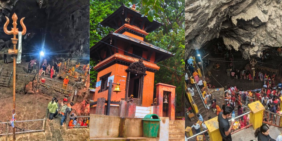
Halesi Mahadev Main Cave — The Inner Sanctuary
The heart of the entire pilgrimage is the main Halesi Mahadev cave — a natural limestone cave of considerable depth and atmospheric power. As pilgrims enter through the cave’s narrow passages and descend toward the inner sanctum, the spiritual intensity of the space is palpable. The two-foot Shiva Linga in the innermost chamber is the primary deity, adorned with offerings of flowers, dhatura leaves, milk, and water during puja ceremonies. The narrow passage between two stone pillars near the Linga — through which all pilgrims attempt to pass — is the most famous feature of the cave.
Tradition holds that those with pure souls pass through easily; others may struggle. Whether or not one subscribes to this belief, the ritual is a powerful and moving experience for all who undertake it.
Maratika Cave — Buddhist Jewel of Halesi
Adjacent to the main Halesi cave complex, the Maratika Cave is a separate and equally significant sacred site, particularly for Buddhist pilgrims. According to the Nyingma and other Tibetan Buddhist traditions, Guru Padmasambhava and his consort, Mandarava, practiced a longevity sadhana (spiritual practice) in this cave for three months, receiving the blessings of the Buddha Amitayus (Buddha of Long Life) and attaining the rainbow body of immortal light.
The cave is maintained by a local Buddhist community and decorated with thangka paintings, butter lamps, and ritual offering bowls. Both Hindu and Buddhist pilgrims visit this cave, making it one of the most remarkable interfaith sacred spaces in Asia.
Jayaram Ghat — Sacred River Bathing
Jayaram Ghat, located where the Dudh Koshi River flows through a beautiful gorge approximately 20 km before Halesi, is a sacred bathing ghat where pilgrims traditionally purify themselves before ascending to Halesi Mahadev temple. The river water — crystal clear mountain water flowing from the Khumbu glaciers — is considered purifying and auspicious, and the ritual bath at Jayaram Ghat is an important part of the traditional Halesi pilgrimage sequence for many devotees.
Diktel and Halesi Bazaar
Halesi Bazaar is the main commercial and accommodation hub serving the temple. It has several guesthouses ranging from basic to reasonably comfortable, restaurants serving Nepali meals, prasad (sacred offering food) shops, and local market stalls. The area is most vibrant during major festival periods — particularly Shivaratri and the Shravan Sombar Mondays — when it fills with pilgrims from across eastern Nepal and beyond.
Religious Festivals at Halesi — Transport Planning Guide
Festival timing is critically important for planning transport to Halesi Mahadev. During major festivals, the roads to Halesi carry many times the normal traffic volume, and accommodation in Halesi Bazaar fills up days or weeks in advance. Here is the key festival calendar:
Festival
Timing (approx.)
Significance at Halesi
Maha Shivaratri
Feb–Mar (Falgun)
Biggest festival — hundreds of thousands of pilgrims; most sacred night
Shravan Sombar
July–August (every Monday in Shravan)
Thousands visit every Monday — peak monsoon pilgrimage
Bala Chaturdashi
November–December
Night-long vigil and morning flower offerings for deceased ancestors
Ram Navami
March–April
Major Hindu festival — large gatherings at Halesi
Teej
August–September
Women’s fasting festival — significant Shiva worship
Dashain
October
Family pilgrimage period — temple visits across eastern Nepal
Maha Shivaratri — The Greatest Pilgrimage
Maha Shivaratri (occurring in February or March each year) is the single most important festival at Halesi Mahadev and one of the largest religious gatherings in eastern Nepal. Hundreds of thousands of devotees converge on Halesi from across the country during this period, creating extraordinary scenes of mass devotion but also significant logistical challenges for travelers.
Shivaratri Transport Warning:During Maha Shivaratri, the roads to Halesi become severely congested, guesthouses and lodges in Halesi Bazaar are fully booked weeks in advance, and journey times from Kathmandu can increase significantly due to traffic. Nepal Vehicle Hiring Pvt Ltd strongly recommends: (1) booking your private vehicle at least 1–2 weeks in advance for Shivaratri travel, (2) arranging accommodation in Halesi well ahead, and (3) allowing extra travel time for the final approach to Halesi from Okhaldhunga.
Shravan Sombar — August Mondays
Every Monday (Sombar) during the Shravan month (July–August), Halesi Mahadev draws large numbers of pilgrims — particularly from the Khotang, Solukhumbu, and Udaypur districts. This is the most popular monsoon season pilgrimage period. Roads are wet and in rougher condition during the monsoon, making a 4WD jeep particularly valuable for the Jayaram Ghat to Halesi section.
Road Conditions — Season Guide
Season
Months
Road Conditions
Crowd Level
Recommendation
Post-Monsoon / Autumn
Oct – Dec
Good — dry roads
Moderate
Excellent — clear weather, post-Dashain
Winter
Jan – Feb
Good — cold, clear
Low to Moderate
Good — quiet, Shivaratri in Feb is massive
Spring
Mar – May
Good — warming up
Moderate to High
Excellent — dry roads, Ram Navami pilgrimage
Monsoon (Early)
Jun – Jul
Fair — some rain
Moderate
Manageable — Shravan pilgrims peak in July–Aug
Peak Monsoon
Jul – Aug
Rain-affected — rough
Very High (festival)
Caution — Shravan Sombar draws huge crowds; roads are wet
Late Monsoon
Sep
Improving
Moderate
Good — roads clearing, pre-Dashain period
Monsoon Note:The Okhaldhunga to Halesi section beyond Jayaram Ghat is susceptible to monsoon road damage, slippery surfaces, and occasional landslides during heavy rain (July–August). A 4WD jeep is strongly recommended during these months. Nepal Vehicle Hiring Pvt Ltd monitors road conditions and will advise you of the current status before your departure.
Himalayan sunrise panorama if clear — Everest visible on best days
Day 1 — 9:00–9:30 AM
Khurkot breakfast stop (30–45 min)
Dal bhat / noodles/tea — a common stop for all Halesi travelers
Day 1 — 11:30 AM–12:00 PM
Okhaldhunga — fuel + short rest
Last reliable ATM and fuel point before Halesi
Day 1 — 1:30–3:00 PM
Arrive Halesi Mahadev / Halesi Bazaar
Check in to the guesthouse — freshen up
Day 1 — 4:00–6:00 PM
Evening darshan (worship) at Halesi Mahadev Cave
Main cave temple, Shiva Linga, evening aarti prayers
Day 1 — Evening
Dinner at Halesi Bazaar
Local Dal Bhat, Nepali thali — rest for early morning puja
Day 2 — 5:00–6:00 AM
Morning puja — Halesi Mahadev Temple
Prime darshan time — less crowded, spiritual atmosphere
Day 2 — 7:00–8:00 AM
Visit Maratika Cave (Buddhist / Guru Rinpoche site)
Short walk from the main temple — sacred to both Hindus and Buddhists
Day 2 — 9:00 AM
Jayaram Ghat — holy bath and ritual
Sacred bathing ghat on Dudh Koshi River
Day 2 — 10:00 AM
Depart Halesi for return to Kathmandu
Same route back — arrive Kathmandu 6:00–8:00 PM
This 2-day itinerary is the most popular format for Kathmandu-to-Halesi Mahadev pilgrimage tours. Day 1 covers the full road journey with an evening darshan at the temple; Day 2 is dedicated to morning puja, visiting all the sacred sites (Maratika Cave, Jayaram Ghat), and the return drive to Kathmandu. Most pilgrims find this 2-day format spiritually complete and logistically comfortable.
Overnight Extension: Adding a third day in Halesi is highly recommended for those wishing to experience both the evening aarti (lamp ceremony) and the early-morning darshan over two consecutive days — the most spiritually immersive experience available at Halesi Mahadev.
Practical Tips for the Kathmandu to Halesi Mahadev Journey
Depart Kathmandu by 5:00–5:30 AM — the 7 to 9 hour journey to Halesi requires an early start to arrive with daylight remaining for evening darshan.
Book your vehicle at least 48–72 hours in advance — and 1 to 2 weeks before major festivals like Shivaratri and Shravan Sombar.
Withdraw adequate NPR cash in Kathmandu or Okhaldhunga — ATM and card facilities at Halesi Bazaar are limited and unreliable during peak festival periods.
Arrange Halesi accommodation in advance — particularly for Shivaratri and Shravan Sombar when guesthouses fill up completely weeks ahead.
Wear comfortable, modest clothing appropriate for temple worship — many pilgrims wear traditional white or saffron attire for darshan.
Carry a good torch/headlamp — the caves at Halesi are dimly lit, and some passages are narrow and dark.
Remove footwear before entering the main temple cave and all sacred areas — follow the directions of the temple priests and local custom.
Women in their menstrual cycle are traditionally asked not to enter the main cave sanctum — a firmly observed local custom.
Bring prasad (offerings) — flowers (especially dhatura), milk, and fruits are appropriate offerings for Lord Shiva at Halesi.
Carry motion sickness medication — the Khurkot to Okhaldhunga and Okhaldhunga to Halesi sections involve winding mountain roads with numerous switchbacks.
For the Maratika Buddhist Cave, women are traditionally requested to dress modestly and cover their heads with a shawl.
Carry your own drinking water — bottled water is available in Halesi Bazaar, but it is priced higher during festivals.
Combining Halesi Mahadev with Other Eastern Nepal Destinations
The road from Kathmandu to Halesi passes through or near several other significant destinations that can be combined into a multi-day eastern Nepal itinerary:
Dhulikhel (35 km from KTM): Beautiful hill station with Himalayan panoramas — an ideal overnight stop for those who want a relaxed start before the Halesi journey.
Sunkoshi River Rafting (near Dolalghat): The Sunkoshi is one of Nepal’s finest rafting rivers — river camp operators offer multi-day rafting packages that can be combined with a Halesi pilgrimage.
Okhaldhunga (175 km): The district headquarters has cultural sites and market areas worth exploring as part of an extended itinerary.
Solukhumbu and Everest Region: The road continues from Okhaldhunga toward Salleri and Phaplu — the starting point of the Salleri-to-Lukla overland route to Everest Base Camp. A combined Halesi + Everest region overland trip is a genuinely unique eastern Nepal adventure.
Taplejung and Kanchenjunga Region: Further east from Khotang District, the Taplejung area is the gateway to the Kanchenjunga Base Camp Trek — a remote and extraordinarily beautiful destination for adventurous trekkers.
Why Choose Nepal Vehicle Hiring Pvt Ltd?
Route Experience: Our drivers have extensive experience on the full Kathmandu-to-Halesi Mahadev route — including the rough final section from Jayaram Ghat to Halesi, which requires the most careful and experienced navigation.
Right Vehicles: Mahindra Scorpio 4WD and Toyota Hilux 4WD for groups of 4–7; sedans for small groups; Hiace and coaster buses for large pilgrim parties — always the right vehicle for the group size and road conditions.
Festival Season Expertise: Nepal Vehicle Hiring Pvt Ltd has extensive experience managing Halesi Mahadev pilgrimages during Shivaratri and Shravan Sombar — we understand the road congestion, accommodation challenges, and timing requirements of festival-season travel.
Door-to-Door Service: Hotel pickup from anywhere in Kathmandu — Thamel, Boudha, Patan, or wherever you are staying.
All-Inclusive Pricing: Driver, fuel, and road tolls included in the quoted price. No hidden charges or surprise costs on arrival.
24/7 Booking: WhatsApp, phone, or email — book at any time, receive confirmation within minutes.
Flexible Itinerary: Whether you need a 1-day express transfer, a 2-day pilgrimage package, or a multi-day eastern Nepal tour including Halesi, we tailor the vehicle hire to your exact itinerary and group requirements.
Return Journey Guaranteed: Your return vehicle from Halesi to Kathmandu is booked at the same time as the outward journey — no searching for transport in Halesi Bazaar after your darshan.
Frequently Asked Questions — Kathmandu to Halesi Mahadev 2026-2027
How far is Kathmandu from Halesi Mahadev?
The road distance from Kathmandu to Halesi Mahadev (Halesi Mahadevsthan) in Khotang District is approximately 222-230 km, depending on the exact route taken and the current state of road construction between Okhaldhunga and Halesi.
How long does it take to drive from Kathmandu to Halesi Mahadev?
A private jeep or car takes approximately 7 to 9 hours from Kathmandu to Halesi Mahadev under normal road conditions. With an early 5:00 AM departure from Kathmandu, most travelers arrive in Halesi between 12:30 PM and 2:30 PM, leaving time for afternoon darshan.
What is the 2026 cost of hiring a private jeep from Kathmandu to Halesi Mahadev?
A private jeep hire from Kathmandu to Halesi Mahadev costs approximately NPR 25,000–35,000 (USD 185–260) for the full vehicle, one way. A round-trip private jeep package costs approximately NPR 40,000–55,000 (USD 300–410). This includes driver, fuel, and road tolls.
Is a 4WD jeep necessary for the Kathmandu-Halesi route?
A 4WD jeep is highly recommended — and particularly valuable — for the rough road section between Okhaldhunga / Jayaram Ghat and Halesi. The Kathmandu-Okhaldhunga section on the paved BP Highway and Mid-Hill Highway is manageable for all vehicle types. However, for a comfortable and reliable journey all the way to Halesi Bazaar, a 4WD jeep is the best choice.
Can I take a bus from Kathmandu to Halesi Mahadev?
Yes. Local buses from Gongabu Bus Park in Kathmandu serve Okhaldhunga and Diktel (near Halesi) at NPR 800–1,200 per person, taking 10 to 13 hours with multiple stops. However, private vehicle hire is strongly recommended for pilgrim groups — it is faster, more comfortable, offers hotel pickup, and allows you to plan your darshan timing precisely.
What is the nearest airport to Halesi Mahadev?
Lamidanda Airport (IATA: LDN) in Khotang District is the nearest domestic airport, approximately 45 km from Halesi Mahadev. Domestic flights from TIA Kathmandu to Lamidanda take approximately 45 minutes. From Lamidanda, a jeep or local vehicle covers the final 45 km to Halesi in 1.5 to 2 hours. Flights are weather-dependent and subject to limited schedules.
What permits are required for Halesi Mahadev?
No permits or entry fees are required for visiting the Halesi Mahadev temple. The sacred site is open to all pilgrims and visitors free of charge. However, a small donation to the temple fund is appreciated and customary.
When is the best time to visit Halesi Mahadev?
Halesi Mahadev is open and accessible year-round. The best times for road travel are October to June (dry season), when road conditions are at their best. Maha Shivaratri (February–March) is the most spiritually significant festival period, but draws enormous crowds — book transport and accommodation well in advance. For a quieter but equally spiritual visit, December to February (outside of Shivaratri) offers excellent road conditions and a more peaceful atmosphere.
Can Nepal Vehicle Hiring arrange a complete Halesi pilgrimage package including accommodation?
Yes. Nepal Vehicle Hiring Pvt Ltd can coordinate complete Halesi Mahadev pilgrimage packages, including private vehicle hire from Kathmandu, overnight accommodation in Halesi Bazaar, and return transfer to Kathmandu — all arranged as a single convenient booking. Contact us via WhatsApp or phone for custom package pricing.
Conclusion
The journey from Kathmandu to Halesi Mahadev is much more than a road transfer — it is a pilgrimage through some of eastern Nepal’s most beautiful and culturally rich landscapes, culminating at one of the most spiritually powerful and multi-traditional sacred sites in the entire Himalayan world. Where Hindu, Buddhist, and Kirant spiritual traditions converge in a single cave complex on the banks of the Dudh Koshi River, Halesi Mahadev offers a depth of religious experience that few destinations anywhere can match.
Whether you are a devout pilgrim seeking the blessings of Lord Shiva, a Buddhist practitioner retracing the footsteps of Guru Padmasambhava at Maratika Cave, a cultural traveler interested in the ancient Kirant tradition, or simply an explorer drawn to the extraordinary landscapes of eastern Nepal, the Kathmandu to Halesi Mahadev journey deserves the best possible transport — and that is exactly what Nepal Vehicle Hiring Pvt Ltd provides.
With comfortable private vehicles for every group size, experienced drivers who know every kilometer of this route, all-inclusive transparent pricing, door-to-door hotel pickup in Kathmandu, 24/7 booking support, and festival-season expertise, Nepal Vehicle Hiring Pvt Ltd is your most trusted transport partner for the Halesi Mahadev pilgrimage.
Pokhara to Lamjung Jeep Rental 2026-2027: Complete Guide to Besisahar, Ghalegaun & Annapurna Circuit
Lamjung District is one of Nepal’s most richly rewarding destinations for trekkers, cultural travelers, and adventure enthusiasts alike. Nestled in the Gandaki Province between Pokhara and the great peaks of the Annapurna and Manaslu ranges, Lamjung is home to Besisahar — the official starting point of the legendary Annapurna Circuit Trek — as well as the spectacular Ghalegaun and Ghanpokhara hilltop villages, the cultural Lamjung Durbar heritage site, the rushing Marsyangdi River gorge, and the lower reaches of some of Nepal’s finest trekking trails.
From Pokhara, the journey to Lamjung District is approximately 72 to 110 kilometers, depending on your destination, making it one of the most accessible and rewarding day and multi-day vehicle journeys from the lakeside city. Whether you are beginning the Annapurna Circuit Trek at Besisahar, visiting the hilltop homestay village of Ghalegaun, exploring the cultural Lamjung Durbar, or simply driving the magnificent Marsyangdi River valley for the views, a private jeep from Nepal Vehicle Hiring Pvt Ltd is the best way to make this journey.
This comprehensive 2026-2027guide covers everything you need — vehicle types, detailed costs, the full route, all major destinations in Lamjung District, trekking connections, permits, seasonal guidance, and expert tips for a perfect Pokhara-to-Lamjung jeep rental experience.
About Lamjung District – Nepal’s Annapurna Gateway
Lamjung District is located in Gandaki Province, directly north of Tanahun District and east of Kaski District (where Pokhara is situated). The district is bisected by the powerful Marsyangdi River, which flows southward from the high glaciers of the Manang valley, carving one of Nepal’s most spectacular gorges as it descends through the Lamjung hills toward the Tarai.
The district is dominated by the towering peaks of the Annapurna Himal to its northwest and the Manaslu massif to its northeast. Lamjung Himal (6,983 m) rises directly above the district and is visible from much of the lower valley. The district headquarters, Besisahar, sits at 760 meters at the confluence of the Marsyangdi River and the road from Dumre, and is the starting point for the Annapurna Circuit — one of the world’s most celebrated trekking routes.
Lamjung District Key Facts
Details
Province
Gandaki Province, Nepal
District Headquarters
Besisahar (760 m)
Distance from Pokhara
Approximately 72–110 km (depending on destination)
Drive Time from Pokhara
2 to 4 hours by private jeep
Main River
Marsyangdi River
Key Peaks Visible
Lamjung Himal (6,983 m), Annapurna II (7,937 m), Manaslu (8,163 m)
Lamjung Durbar (historic palace), Gurung and Ghale communities
Famous Attractions
Besisahar, Ghalegaun, Ghanpokhara, Marsyangdi River, Lamjung Durbar
Major Destinations in Lamjung District from Pokhara
Lamjung District contains several distinct destinations, each requiring a jeep transfer from Pokhara. Here is a complete overview of all main destinations:
Destination
Distance from Pokhara
Drive Time
Altitude
Best For
Besisahar
72–80 km
2 to 2.5 hours
760 m
Annapurna Circuit start, permit collection, Marsyangdi River
Ghalegaun
90–100 km
3 to 4 hours
1,950 m
Ghale cultural village, homestay, Annapurna–Manaslu views
Ghanpokhara
95–110 km
3.5 to 4 hours
2,100 m
Hilltop viewpoint, traditional Gurung village, less-trodden
Paved Pokhara to Besisahar; rough off-road to Ghalegaun and Ghanpokhara
Vehicle Required
Any vehicle to Besisahar; 4WD jeep mandatory for Ghalegaun and beyond
Departure Point (Sharing)
Prithvi Chowk / Baglung Bus Park, Pokhara
Recommended Departure
6:30 AM – 7:30 AM for Ghalegaun/Ghanpokhara; 7:00–8:00 AM for Besisahar
Key Permit
ACAP permit + TIMS card for Annapurna Circuit trekkers
Why Hire a Private Jeep from Pokhara to Lamjung?
4WD is Essential for Ghalegaun, Ghanpokhara, and Upper Routes
While the road from Pokhara to Besisahar via Dumre is mostly well-paved and accessible by any vehicle, the roads continuing to Ghalegaun, Ghanpokhara, and the upper Marsyangdi valley beyond Besisahar are rough, steep, narrow mountain tracks that require a 4WD vehicle with high ground clearance. Nepal Vehicle Hiring provides reliable 4WD jeeps for all destinations in Lamjung.
Door-to-Door Hotel Pickup from Pokhara
Your Nepal Vehicle Hiring driver collects you directly from your hotel in Pokhara Lakeside. There is no need to travel to a bus station with luggage and trekking gear. For groups beginning the Annapurna Circuit or traveling to Ghalegaun, this door-to-door convenience is a genuine advantage.
Flexibility for Sightseeing Along the Route
The Pokhara to Besisahar drive passes through beautiful landscapes, the Marsyangdi River valley, and the attractive hill town of Dumre. A private jeep from Nepal Vehicle Hiring allows you to stop at viewpoints, cultural sites, and riverside teahouses at your own pace — something impossible on a public bus.
Best Option for Annapurna Circuit Trekking Groups
Groups beginning the Annapurna Circuit Trek need to carry significant luggage — personal trekking bags, porter loads, guides’ equipment, and group supplies. A private jeep offers ample space for all of this in one comfortable vehicle, with the entire group departing together at a time that suits the trek itinerary.
Return Pickup After the Trek
Nepal Vehicle Hiring arranges return vehicle transfers from Besisahar, Bhulbhule, Jomsom, or anywhere your Annapurna Circuit Trek ends. Booking the outbound Pokhara-to-Besisahar jeep and the return vehicle as a combined arrangement with us simplifies the entire trekking logistics chain.
Vehicle Options: Pokhara to Lamjung Jeep Rental 2026
Vehicle Type
Capacity
Besisahar Cost (NPR)
Ghalegaun Cost (NPR)
Best For
Sharing a Jeep (per person)
7–8 pax total
NPR 700–1,000/person
NPR 1,200–1,800/person
Solo budget travellers
Private Car (to Besisahar only)
2–4 pax
NPR 6,000–9,000
Not recommended
Small groups, Besisahar only
Private Jeep – Standard
4–5 pax
NPR 8,000–12,000
NPR 12,000–18,000
Trekking groups, families
Private Jeep – 4WD Hilux/Fortuner
5–6 pax
NPR 10,000–15,000
NPR 15,000–22,000
Ghalegaun, Ghanpokhara, upper routes
Private Jeep – Land Cruiser
5–6 pax
NPR 14,000–20,000
NPR 20,000–30,000
Premium, Chame, and beyond
Toyota Hiace Van
7–10 pax
NPR 14,000–20,000
Not suitable beyond Besisahar
Large groups to Besisahar
Note: All private vehicle prices include driver and fuel. Round-trip prices are approximately 1.7–1.9 times the one-way price. Contact Nepal Vehicle Hiring for confirmed quotes for your specific destination and date.
Pokhara to Besisahar – Annapurna Circuit Starting Point
Besisahar is the district headquarters of Lamjung District and the traditional starting point of the Annapurna Circuit Trek — one of the world’s most celebrated trekking routes. Situated at 760 meters above sea level at the confluence of the Khudi and Marsyangdi rivers, Besisahar is a lively bazaar town with banks, ATMs, guesthouses, restaurants, and permit collection facilities that serve thousands of trekkers each year.
Why Trekkers Go to Besisahar
Official starting checkpoint for the Annapurna Circuit Trek permit registration
Last reliable ATM and bank before the remote upper Marsyangdi valley
Well-stocked market for last-minute trekking supplies, snacks, and gear
Starting point for jeep transport further up the valley to Chame, Dharapani, or Manang
Cultural mix of Gurung, Ghale, and Brahmin communities in the local market
Pokhara to Besisahar Route
The drive from Pokhara to Besisahar follows the Prithvi Highway eastward toward Damauli, then continues along it to the Dumre junction. At Dumre, the road turns north and follows the Marsyangdi River upstream for approximately 40 km to Besisahar. The road from Pokhara to Besisahar is well-paved and comfortable throughout.
Detail
Information
Distance
72–80 km from Pokhara
Drive Time
2 to 2.5 hours (private jeep)
Road Type
Paved throughout – comfortable for all vehicle types
Besisahar to Chame – Deep Annapurna Circuit Access
Many trekkers who start the Annapurna Circuit at Besisahar take a further jeep ride to Chame (2,670 m) or even Dharapani, skipping the lower-valley road sections and beginning the proper trekking in the higher, more scenic terrain. The Besisahar-to-Chame jeep journey covers approximately 68 km of increasingly rough and spectacular mountain road through Jagat and Dharapani.
Segment
Distance
Drive Time
Road Type
Cost (NPR)
Besisahar to Jagat
32 km
1.5–2 hours
Rough off-road
NPR 1,500–2,500 per jeep
Besisahar to Dharapani
50 km
2.5–3 hours
Very rough mountain track
NPR 3,000–5,000 per jeep
Besisahar to Chame
68 km
3.5–4.5 hours
Rough mountain track – 4WD mandatory
NPR 5,000–8,000 per jeep
Pokhara to Ghalegaun – The Famous Ghale Cultural Village
Ghalegaun is one of Nepal’s most celebrated cultural heritage villages and one of the finest homestay destinations in the entire Annapurna region. Sitting on a beautiful hilltop ridge at approximately 1,950 meters above sea level, the village is home to the indigenous Ghale community — a Tibeto-Burman people with a unique language, culture, and traditional architecture that are distinct from those of the surrounding Gurung and Brahmin communities.
The village offers spectacular panoramic views of the Annapurna range, Manaslu (8,163 m), Lamjung Himal (6,983 m), and the Marsyangdi River valley far below. The village is famous for its traditional stone-paved lanes, warm community homestays, cultural dance performances, and authentic Ghale cuisine. Ghalegaun was one of Nepal’s first officially recognized community tourism destinations.
Road Conditions: Pokhara to Ghalegaun
The road from Pokhara to Ghalegaun follows the same Prithvi Highway and Dumre–Besisahar route as far as Khudi (approximately 90 km from Pokhara), then turns off onto a steep, rough, and winding jeep track that climbs dramatically to Ghalegaun village at 1,950 meters. This off-road section from Khudi to Ghalegaun is approximately 10-15 km long and requires a 4WD jeep with an experienced driver. The road is narrow, steep, and unpaved in sections — impassable for standard cars and vans.
Detail
Information
Distance from Pokhara
90–100 km
Drive Time
3 to 4 hours
Road to Khudi
Paved – comfortable for all vehicles
Road Khudi to Ghalegaun
Rough, steep off-road track – 4WD mandatory
Altitude
1,950 meters
Private Jeep Cost (One Way)
NPR 12,000–18,000
Private Jeep Cost (Round Trip)
NPR 20,000–30,000
Sharing Jeep Cost
NPR 1,200–1,800 per person
Best Season
Spring (March–May), Autumn (September–November)
Famous For
Ghale community homestays, Annapurna–Manaslu views, cultural dances
Why Ghalegaun is Worth the Journey
Panoramic views of Manaslu, Lamjung Himal, Annapurna II, and the Marsyangdi valley
Authentic Ghale community homestay experience — sleeping and eating with local families
Traditional cultural programs, including Ghale dance, music, and dress
Stone-paved village lanes, traditional architecture, and a genuine community atmosphere
Starting point for the beautiful Ghalegaun–Ghanpokhara trekking circuit
Much less crowded than mainstream Annapurna trekking destinations
One of Nepal’s finest community tourism success stories
Pokhara to Ghanpokhara – The Hidden Viewpoint Village
Ghanpokhara is a traditional Gurung village perched at approximately 2,100 meters on the ridge system above the Marsyangdi valley, just a few kilometers northeast of Ghalegaun. The village is less well-known than Ghalegaun but offers equally spectacular views and a more off-the-beaten-track cultural experience.
The name Ghanpokhara means thick/dense pond in Nepali — a reference to the many natural springs and water sources in the area. The village has a traditional Gurung community with a rich agricultural and pastoral way of life and offers homestays for visitors. The views of Manaslu, Lamjung Himal, and the Marsyangdi gorge from Ghanpokhara are outstanding.
Lamjung Durbar is a historically significant palace complex located in Sundarbazar, approximately 80-90 km from Pokhara, in the central part of Lamjung District. The durbar (palace) was the seat of the ancient Lamjung Kingdom, which was one of the independent hill kingdoms of medieval Nepal before unification under Prithvi Narayan Shah in the 18th century.
The palace complex features traditional Nepali architectural styles with pagoda-roofed temples, stone carvings, and historic courtyards. It is an important cultural heritage site for the Gurung and Ghale communities of Lamjung, and a fascinating destination for travelers interested in Nepal’s pre-unification royal history.
Detail
Information
Location
Sundarbazar, Lamjung District
Distance from Pokhara
80–90 km
Drive Time
2.5 to 3 hours
Historical Significance
Former seat of the Lamjung Kingdom (pre-18th century)
Architecture
Traditional Nepali pagoda-style palace and temples
Entry Fee
Nominal local entry fee
Private Jeep Cost (One Way)
NPR 8,000–14,000
Best Combined With
Ghalegaun or Besisahar on a full-day or multi-day trip
Pokhara to Lamjung Route Breakdown – Stage by Stage
Here is a complete stage-by-stage guide to the road from Pokhara to the main Lamjung destinations:
Stage 1: Pokhara to Damauli – Approx. 40 km (1 hour)
The journey from Pokhara heads east along the Prithvi Highway. The road passes through the Pokhara valley, the Seti River bridge, and climbs through the attractive midhill town of Damauli — the headquarters of Tanahun District, situated at the confluence of the Seti and Madi rivers. Damauli is an excellent stop for tea or an early breakfast. The mountain views from the highway near Damauli on a clear morning, with the Annapurna range visible to the north, are already excellent.
Stage 2: Damauli to Dumre Junction – Approx. 25 km (30 minutes)
From Damauli, the Prithvi Highway continues northeast along the Marsyangdi valley. Dumre is the key junction town where the highway to Kathmandu continues east and the road north to Besisahar and Lamjung branches off. Dumre is a busy roadside town and a reliable fuel and snack stop. Your Nepal Vehicle Hiring driver will brief you at Dumre about the road conditions ahead.
Stage 3: Dumre to Besisahar – Approx. 40 km (1 hour)
From Dumre, the road heads north, following the Marsyangdi River upstream through increasingly beautiful river-valley scenery. The road is paved throughout this section. You pass through small riverside towns and farmland, with the Marsyangdi River rushing on one side and terraced hillsides rising on the other. The first views of the high Himalayan peaks begin to appear ahead as you approach Besisahar.
Stage 4: Besisahar to Ghalegaun via Khudi – Approx. 20–25 km (1.5 to 2 hours)
From Besisahar, the road continues north to Khudi before the Ghalegaun jeep track turns sharply uphill to the west. The Khudi to Ghalegaun section is the most challenging stretch of driving on the entire journey — steep switchbacks, narrow width, and rough surface. A skilled 4WD driver is essential. The reward for this challenging approach is the spectacular ridgetop arrival at Ghalegaun village with its panoramic Himalayan views.
Route Overview Table: Pokhara to Lamjung
Stage
Section
Distance
Road Condition
Key Highlights
1
Pokhara to Damauli
40 km
Prithvi Hwy – smooth
Seti River bridge, midhill views, Damauli tea stop
2
Damauli to Dumre
25 km
Prithvi Hwy – smooth
Marsyangdi valley entry, Dumre junction, and fuel stop
3
Dumre to Besisahar
40 km
Paved – good condition
Marsyangdi River views, first Himalayan peaks visible
Deep gorge, waterfalls, Annapurna Circuit trail villages
Top Attractions in Lamjung District
Marsyangdi River Valley
The Marsyangdi River is the heart and soul of Lamjung District. Originating high in the glaciers of the Manang valley, the river rushes through a dramatic gorge flanked by steep forested hillsides, waterfalls, and traditional riverside villages. The drive along the Marsyangdi from Dumre to Besisahar and beyond is one of the most beautiful river-valley drives in Nepal, with the river’s turquoise-green water, the distant snow peaks, and the dramatic vertical relief of the valley walls creating constantly changing scenery.
Ghalegaun Village and Homestay
Ghalegaun is widely regarded as one of Nepal’s finest community tourism destinations. The traditional Ghale stone houses with carved wooden windows, the community-run homestays offering authentic local food and cultural programs, and the panoramic views of the Annapurna–Manaslu range make this village a destination that offers a deeply authentic Himalayan community experience. An overnight homestay in Ghalegaun is one of the most memorable experiences in Nepal, and it is within easy reach of Pokhara.
Lamjung Himal Views
Lamjung Himal (6,983 m) is the peak that gives the district its name and is one of the most distinctive and beautiful mountains in the Annapurna region. From Ghalegaun and Ghanpokhara on clear mornings, Lamjung Himal rises directly above the valley in a perfect snow pyramid, with the higher summits of Annapurna II (7,937 m) and Manaslu (8,163 m) visible on either side. Few viewpoints in Nepal offer such immediate and dramatic access to high Himalayan peaks.
Khudi Waterfall and Marsyangdi Confluence
Khudi village, located at the confluence of the Khudi and Marsyangdi rivers approximately 10 km north of Besisahar, is both a key access point for the Ghalegaun road and the site of a beautiful waterfall on the Khudi Khola. The village is also the starting point for the Annapurna Circuit trekking trail, making it a popular halt for trekkers and jeep travelers alike.
Sundarbazar and Lamjung Durbar
Sundarbazar is a pleasant market town in central Lamjung that serves as the cultural and administrative center of the district’s mid-region. The nearby Lamjung Durbar palace complex is the district’s principal historical monument and an important site for understanding Nepal’s pre-unification royal history. The combination of the market-town atmosphere and the ancient palace ruins makes Sundarbazar a rewarding half-day cultural stop.
Bandipur Day Trip Extension
The beautiful heritage hill town of Bandipur is located just off the Prithvi Highway between Damauli and Dumre. Including a Bandipur stop on the Pokhara-to-Lamjung jeep journey adds approximately 1 to 1.5 hours to the total travel time, but includes one of Nepal’s finest traditional Newari towns in the day’s itinerary. Bandipur’s cobblestone main street, panoramic mountain views, and the nearby Siddha Cave make it an outstanding addition.
Annapurna Circuit Trek – Jeep Transport from Pokhara to Besisahar and Beyond
The Annapurna Circuit is one of the world’s great trekking adventures — a 160 to 230 km circuit through the Annapurna Conservation Area crossing the legendary Thorong La Pass (5,416 m). Besisahar in Lamjung District is the traditional starting point of the circuit, and the journey from Pokhara to Besisahar is the first transport leg for all trekkers beginning the circuit from Pokhara.
Annapurna Circuit Transport
Details
Pokhara to Besisahar (Jeep)
72–80 km, 2–2.5 hrs – starting point of the circuit
Nepal Vehicle Hiring arranges complete Annapurna Circuit transport packages — outbound: private jeep from Pokhara to Besisahar (or Chame), plus return: private jeep from Jomsom or Nayapul to Pokhara — as a single coordinated booking.
The Ghalegaun Homestay Trek is one of the most rewarding short cultural treks available from Pokhara. The typical itinerary involves driving to Ghalegaun by jeep, spending 1 to 2 nights in a community homestay, and either driving back to Pokhara or trekking the beautiful trail to Ghanpokhara before returning by jeep. Nepal Vehicle Hiring provides complete vehicle packages for this popular tour.
Package
Days
Vehicle
Includes
Cost (NPR)
Ghalegaun Day Trip
1 day
Private Jeep (return)
Pokhara–Ghalegaun–Pokhara round trip
NPR 20,000–30,000
Ghalegaun Overnight
2 days
Private Jeep (one way each)
Drop-off Day 1, Return Day 2
NPR 22,000–32,000
Ghalegaun–Ghanpokhara
2–3 days
Private Jeep both ends
Drop to Ghalegaun, return from Ghanpokhara
NPR 25,000–38,000
Note: Vehicle package prices are for the vehicle only and do not include homestay fees, meals, or guide costs. Contact Nepal Vehicle Hiring to discuss full travel arrangements.
Permits Required for Lamjung District Destinations
Permit
Cost
Required For
Where to Obtain
ACAP – Annapurna Conservation Area Permit
NPR 3,000 (foreigners)
Annapurna Circuit, Besisahar, Bhulbhule, Chame, and all the ACAP area
Nepal Tourism Board, Pokhara Lakeside, or Kathmandu
TIMS Card
NPR 2,000 (foreigners)
All trekkers on multi-day routes in the Annapurna region
Nepal Tourism Board, Pokhara Lakeside
Ghalegaun Community Entry
NPR 500–1,000 (approx.)
Ghalegaun and Ghanpokhara village entry
Paid at the village entrance
Lamjung Durbar Entry
Nominal fee
Lamjung Durbar historical site
Paid at the site
Permits for trekking in the Annapurna Conservation Area (ACAP and TIMS) should be obtained in Pokhara Lakeside before departure. The Nepal Tourism Board office is approximately 10 minutes from Pokhara Lakeside.
Best Time for Pokhara to Lamjung Jeep Rental
Autumn (September to November) – Best Season
Autumn is the finest season for the Pokhara-Lamjung jeep journey. Post-monsoon skies are crystal clear, the roads are in excellent condition after monsoon grading, and the mountain views of Lamjung Himal, Annapurna II, and Manaslu from Ghalegaun and Ghanpokhara are outstanding. October and November are peak trekking season for the Annapurna Circuit — book your vehicle transfer well in advance.
Spring (March to May) – Excellent
Spring offers warm, comfortable travel conditions with rhododendron forests in full bloom along the Marsyangdi valley hillsides. The mountain views are excellent, and the cultural villages of Ghalegaun and Ghanpokhara are at their most vibrant. March and April are particularly recommended. May can see pre-monsoon haze develop, but it remains a rewarding travel month.
Winter (December to February) – Good
Winter travel to Lamjung is peaceful and uncrowded. The roads to Besisahar are open year-round. The rough road to Ghalegaun may have frost in the mornings in December and January, but it remains passable with a good 4WD jeep. Mountain views from Ghalegaun in winter are spectacular. Bring warm clothes for the overnight stay.
Monsoon (June to August) – Not Recommended for Upper Roads
The monsoon season brings heavy rainfall, making the rough off-road tracks to Ghalegaun and Ghanpokhara particularly hazardous due to slippery surfaces and occasional landslides. The paved road from Pokhara to Besisahar is generally fine. Nepal Vehicle Hiring advises against the Ghalegaun and Ghanpokhara routes during the core monsoon months of July and August.
What to Pack for the Pokhara to Lamjung Jeep Journey
Warm layers and a fleece – Ghalegaun (1,950 m) and Ghanpokhara (2,100 m) are significantly cooler than Pokhara, especially in the evenings.
Rain jacket – the Marsyangdi valley can receive afternoon rain even outside the monsoon season
Trekking permits (ACAP + TIMS) if trekking – obtain from Nepal Tourism Board in Pokhara before departure.
Camera and wide-angle lens – Ghalegaun and Ghanpokhara offer spectacular panoramic mountain photography opportunities
Nepali cash (small denominations) – for community entry fees, homestay payments, meals, and roadside stops
Water bottle and light snacks – the Dumre to Besisahar section has limited roadside food options
Motion sickness tablets – the Khudi to Ghalegaun road involves steep, winding switchbacks.
Comfortable walking shoes – even if not trekking, the village lanes of Ghalegaun are best explored on foot
Sunscreen and sunglasses – UV intensity at 1,950 meters is significantly higher than at Pokhara
Offline maps (download the area in Maps.me) – mobile data coverage is limited above Besisahar
Expert Tips for Pokhara to Lamjung Jeep Rental
Book your private jeep at least 2 to 3 days in advance, and 5 to 7 days in advance during the October, November, March, and April peak seasons.
For the Ghalegaun road specifically, always request an experienced driver who has made the Khudi to Ghalegaun route before – the steep switchbacks require specific local knowledge.
Collect ACAP and TIMS permits from the Nepal Tourism Board in Pokhara Lakeside before departure if you are trekking – the permit office is open daily from 9:00 AM to 5:00 PM.
Depart from Pokhara between 7:00 AM and 7:30 AM for Ghalegaun – arriving before noon gives you a full afternoon in the village.
For the Annapurna Circuit transfer to Besisahar, a 7:00 AM departure from Pokhara allows you to reach Besisahar by 9:30 AM, leaving a full day for the first trekking stage.
If adding a Bandipur stop on the way to Lamjung, plan for a 6:30 AM departure to maintain a good arrival time at your final destination.
Carry sufficient Nepali cash from Pokhara – ATMs in Besisahar are limited and unreliable, and there are none beyond Besisahar on the Annapurna Circuit.
Ask your Nepal Vehicle Hiring driver about current road conditions to Ghalegaun on the morning of departure – conditions can change after overnight rain.
For multi-day Lamjung trips that combine Ghalegaun homestay and Besisahar, Nepal Vehicle Hiring can arrange a single-booking itinerary covering both destinations.
How to Book Your Pokhara to Lamjung Jeep Rental
Booking your Lamjung jeep rental with Nepal Vehicle Hiring Pvt Ltd is straightforward:
Step 1: Contact us via phone, WhatsApp, or at vehiclehiringnepal.com
Step 2: Tell us your travel date, specific destination in Lamjung (Besisahar, Ghalegaun, Ghanpokhara, Chame, or Lamjung Durbar), group size, and hotel in Pokhara
Step 3: Choose your vehicle – sharing jeep, private jeep, Hilux/Fortuner, or Land Cruiser
Step 4: Confirm one-way, round-trip, or multi-day arrangement as required
Step 5: Receive your booking confirmation with driver details, vehicle information, and pickup time
Step 6: Your driver picks you up from your hotel and begins your Lamjung adventure
For Annapurna Circuit trek transport packages, including return vehicle from Jomsom or Nayapul, contact us to discuss a complete combined booking.
Frequently Asked Questions (FAQ)
How far is Pokhara from Besisahar in Lamjung?
The road distance from Pokhara to Besisahar is approximately 72-80 kilometers. By private jeep, the drive takes 2 to 2.5 hours along the Prithvi Highway and the Dumre–Besisahar road.
How long does it take to drive from Pokhara to Ghalegaun?
The drive from Pokhara to Ghalegaun takes approximately 3 to 4 hours by private 4WD jeep. The road is paved and smooth as far as Khudi, then becomes a steep, rough off-road track for the final 1- 15 km to Ghalegaun village.
Is a 4WD jeep necessary for the drive from Pokhara to Ghalegaun?
Yes. A 4WD jeep is required for the Khudi-to-Ghalegaun off-road section. Standard cars and vans cannot manage this route. Nepal Vehicle Hiring offers only 4WD jeeps for transfers to Ghalegaun.
What is the cost of a private jeep from Pokhara to Besisahar in 2026?
A one-way private jeep from Pokhara to Besisahar costs approximately NPR 8,000-12,000 (USD 60–90). A round trip costs NPR 14,000 to 20,000. All prices include driver and fuel.
What is the best starting point for the Annapurna Circuit from Pokhara?
Besisahar is the traditional and most commonly used starting point. Trekkers who want to skip the lower, less scenic Marsyangdi valley road section often take a further jeep from Besisahar to Chame or Dharapani, reducing the circuit trekking time by 2 to 3 days.
What permits do I need for Lamjung District?
For the Annapurna Circuit and ACAP area (Besisahar and beyond), you need an ACAP permit (NPR 3,000) and a TIMS card (NPR 2,000). For Ghalegaun and Ghanpokhara cultural visits, a community entry fee of approximately NPR 500-1,000 is paid at the village. Both ACAP and TIMS permits are available from the Nepal Tourism Board office in Pokhara Lakeside.
Can Nepal Vehicle Hiring arrange transport for the full Annapurna Circuit loop?
Yes. Nepal Vehicle Hiring arranges complete Annapurna Circuit transport — a private jeep from Pokhara to Besisahar or Chame at the start, and a return vehicle from Jomsom to Pokhara or from Nayapul to Pokhara at the circuit end. Contact us to discuss a complete trekking transport package for your group.
What is Ghalegaun famous for?
Ghalegaun is famous for its indigenous Ghale community homestays, spectacular panoramic views of Manaslu, Lamjung Himal, and the Annapurna range, traditional cultural programs, and authentic Ghale cuisine. It is one of Nepal’s most acclaimed community tourism destinations and is widely considered the finest homestay village in the Annapurna foothills.
Book Your Pokhara to Lamjung Jeep Rental with Nepal Vehicle Hiring
Lamjung District is one of Nepal’s great undiscovered treasures — a region of dramatic river gorges, towering Himalayan peaks, ancient cultural villages, and some of the world’s finest trekking trails, all within easy reach of Pokhara by private jeep. Whether you are beginning the Annapurna Circuit in Besisahar, experiencing the Ghale community culture, marveling at the mountain panorama from Ghanpokhara, or historic Lamjung hhistoricLamjung Durbar, every destination in this remarkable district offers the traveler experiences that are genuinely unique to Nepal.
Nepal Vehicle Hiring Pvt Ltd provides the most reliable, professional, and competitively priced jeep rental service for the Pokhara-Lamjung route. Our 4WD fleet, experienced mountain drivers, and complete trekking transport coordination make us the preferred vehicle partner for the Annapurna region.
Contact Nepal Vehicle Hiring Pvt Ltd today at vehiclehiringnepal.com to book your Pokhara-to-Lamjung jeep rental and begin your Annapurna adventure.
Pokhara to Manang Transport – Route, Cost & Trek Guide 2026
Manang is one of the most extraordinary villages in Nepal – a high-altitude Tibetan-influenced settlement at 3,500 m in the heart of the Annapurna Circuit, sitting beneath the towering walls of Annapurna III (7,555 m), Gangapurna (7,455 m), and the Gangapurna Glacier. Every trekker doing the Annapurna Circuit passes through Manang – it is the last major village before the circuit’s highest and most challenging section, and the obligatory acclimatization stop before attempting the Thorong La Pass at 5,416 m.
In 2026, reaching Manang from Pokhara by private jeep or vehicle is increasingly popular among trekkers who want to skip the lower sections of the Annapurna Circuit (now largely alongside a jeep road) and begin trekking from the spectacular high-altitude terrain above Chame and Manang. This complete guide covers every aspect of the Pokhara-to-Manang journey – transport options, route details, road conditions, costs, the Manang experience, Annapurna Circuit trek stages, altitude safety, permits, and expert tips for 2026.
About Manang – The High-Altitude Gateway
Location: Manang Village, Manang District, Gandaki Province, Nepal
Altitude: 3,500 m above sea level
Distance from Pokhara: Approximately 175–185 km by road via Besisahar
Distance from Besisahar: Approximately 95 km north by mountain road
Travel Time from Pokhara: 8 to 12 hours total by 4WD jeep (usually done in 2 days)
Road Type: Pokhara to Besisahar – paved | Besisahar to Chame – rough mountain track | Chame to Manang – improved track with some paved sections
Vehicle Required: 4WD Jeep mandatory from Besisahar onwards – no sedan, no Hiace beyond Besisahar
Trek Position: Manang is the Day 8–10 stop on the Annapurna Circuit Trek from Besisahar, or Day 5–6 if starting from Chame by vehicle
Population: Approximately 1,500 – Gurung and Tibetan Buddhist community
Manang sits in a wide, open valley at the foot of the Gangapurna Glacier – an extraordinary landscape of raw Himalayan grandeur. The village itself is a dense cluster of flat-roofed stone houses, prayer flags, ancient gompas, and the sounds of yak bells. Above the village, the Gangapurna Glacier descends in a dramatic cascade of blue ice and grey moraine. To the south, Annapurna III and Gangapurna rise in vertical walls of rock and ice. To the north, the high dry plateau of the Annapurna Circuit stretches towards the Thorong La. Manang is, for most Annapurna Circuit trekkers, the most beautiful and memorable overnight stop of the entire circuit.
Why Drive from Pokhara to Manang by Private Vehicle?
The traditional Annapurna Circuit trek starts in Besisahar and continues to Manang over 8 to 10 days. However, the road from Besisahar to Chame and beyond has been significantly developed in recent years, and most of the lower circuit now runs alongside or on a jeep track. Many experienced trekkers in 2026 choose to drive from Pokhara to Manang (or at least to Chame) and begin the most scenic sections of the circuit on foot. Here is why:
Save 6 to 8 days of walking on the lower circuit sections that now largely follow the jeep road and offer less traditional trekking atmosphere
Begin trekking at Manang (3,500 m) in the most dramatically beautiful section of the entire Annapurna Circuit
The lower sections from Besisahar to Chame are now widely considered the least rewarding part of the circuit due to road construction and vehicle traffic alongside the trail
A 4WD private jeep gives full luggage space, and group travel together – no splitting the group across multiple local shared jeeps
Flexible departure from your Pokhara hotel – choose your own schedule and rest stop locations
Combine the circuit with Muktinath and Mustang by entering from Pokhara and exiting via Jomsom
Arrive fresher and stronger for the genuinely challenging high-altitude sections above Manang
Vehicle Options & Prices: Pokhara to Manang Transport 2026
The Pokhara-Manang route requires a capable 4WD vehicle from Besisahar onwards. Here are the vehicle options and 2026 prices:
Vehicle
Capacity
One-Way Price (USD)
Round Trip (USD)
Notes
Toyota Land Cruiser
4–6 pax
$200 – $260
$320 – $420
Best vehicle for the full Pokhara–Manang road
Toyota Land Cruiser Prado
4–5 pax
$220 – $280
$350 – $450
Superior comfort on rough mountain track
Mahindra Bolero / Scorpio
4–6 pax
$170 – $220
$280 – $360
Budget 4WD, capable on this route
Hiace Van (Pokhara–Besisahar only)
7–14 pax
$100–$135
$170–$230
Cannot proceed beyond Besisahar – jeep required
Sedan Car (Pokhara–Besisahar only)
1–3 pax
$70–$95
$120–$165
Paved road to Besisahar only – not beyond
All private vehicle prices include driver, full fuel, and vehicle insurance. Round-trip pricing includes the driver staying in Manang or Chame during your trek and returning you to Pokhara or Kathmandu after the circuit. For trekkers completing the full Annapurna Circuit and exiting via Jomsom to Pokhara, a one-way Pokhara-to-Manang booking is all that is needed.
This is the standard and most commonly used route. The road from Pokhara to Dumre follows the Prithvi Highway and is fast and paved. From Dumre, the road climbs north to Besisahar on a secondary road. Beyond Besisahar, the rough mountain track begins through the Marsyangdi River valley to Chame and finally Manang.
Route B: Pokhara – Beshisahar via Damauli (Alternative)
A slightly shorter alternative that bypasses the longer Pokhara-Prithvi Highway stretch by heading east via Damauli before joining the Besisahar road. Both routes converge at Besisahar. Your driver will choose the best option based on traffic and road conditions on your travel day.
Detailed Road Guide: Pokhara to Manang Stage by Stage
Stage 1: Pokhara to Dumre (75 km | ~1.5 hrs)
Depart your Pokhara hotel early – 5:30 to 6:00 AM is ideal for a two-day journey with an overnight in Besisahar or Chame. Head east on the Prithvi Highway through the Pokhara valley, past Damauli and Dumre. Dumre is the junction town on the Prithvi Highway where the road branches north toward Besisahar and the Annapurna Circuit. Stock up on snacks here if needed – the highway shops are more convenient than the mountain road ahead.
Stage 2: Dumre to Besisahar (22 km | 45 min)
From Dumre, head north on the secondary road into the Marsyangdi River valley. The road climbs gently through terraced hills and farmland to Besisahar – the district headquarters of Lamjung District and the official starting point of the Annapurna Circuit. The road is mostly paved. Besisahar has the last reliable ATMs on the circuit, a good selection of teahouses, pharmacies, and a well-stocked market. Stop here to withdraw cash, complete ACAP permit registration at the checkpoint, refuel, and have breakfast or an early lunch before the mountain road begins.
Stage 3: Besisahar to Chame (55 km | 4–6 hrs by 4WD)
This is the most challenging section of the drive. Beyond Besishahar, the paved road ends, and the rough Annapurna Circuit mountain track begins. The route follows the Marsyangdi River north through dramatically deepening gorges. Key villages and landmarks on this section:
Khudi (790 m) – First village on the track, 10 km from Besisahar
Bahundanda (1,310 m) – Brahmin village on ridge, good views back down valley
Chamje (1,430 m) – Bridge crossing to the east bank, gorge narrows dramatically
Tal (1,700 m) – First village in Manang District, flat valley formed by an ancient landslide dam
Dharapani (1,860 m) – Important permit checkpoint, Manaslu Circuit junction point
Bagarchhap (2,160 m) – First Tibetan-style stone buildings appear
Chame (2,710 m) – District headquarters of Manang, hot springs, good teahouses, end of Day 2 drive
Overnight in Chame (2,710 m) is strongly recommended for acclimatization before continuing to Manang at 3,500 m. Ascending too quickly from Besisahar to Manang in a single day significantly increases the risk of altitude sickness.
Stage 4: Chame to Manang (40 km | 2–3 hrs by 4WD)
The road from Chame to Manang is more manageable than the Besisahar–Chame section, with some paved sections and generally better track surface. The scenery becomes increasingly dramatic as you enter the high-altitude Annapurna landscape. Key stops:
Bhratang (2,850 m) – Apple orchard settlement, dramatic Paungda Danda rock face
Dhukur Pokhari (3,240 m) – Small pond, open plateau, Annapurna III views begin
Upper Pisang (3,310 m) – Beautiful perched Tibetan village with an ancient monastery (worth a stop)
Ngawal (3,657 m) – Spectacular viewpoint village above the main road
Braga (3,475 m) – Ancient cave monastery with some of Nepal’s finest Buddhist art
Manang (3,500 m) – Arrival at the circuit’s most important acclimatization village
Road Conditions: Pokhara to Manang
Section
Distance
Surface
Difficulty
Best Season
Pokhara to Dumre
75 km
Prithvi Hwy – paved
Easy
Good year-round
Dumre to Besisahar
22 km
Secondary road – mostly paved
Easy–Moderate
Good year-round
Besisahar to Bahundanda
15 km
Rough gravel track
Moderate
Muddy in monsoon
Bahundanda to Chamje
10 km
Rocky Mountain track
Hard
4WD essential, rockfall risk
Chamje to Tal
8 km
Very rough, river crossings
Very Hard
Risk in monsoon
Tal to Dharapani
12 km
Rough track, improving
Hard
Best Oct–May
Dharapani to Chame
15 km
Mixed – rough to partly paved
Moderate–Hard
Reliable in the dry season
Chame to Pisang
20 km
Mixed track – some paved
Moderate
Good Oct–May
Pisang to Manang
20 km
Better track – partly paved
Moderate
Good Oct–May, snow risk Dec–Feb
The Besisahar-to-Chame section remains the most challenging part of the drive and requires a fully capable 4WD Land Cruiser with an experienced mountain driver. Road conditions improve significantly from Chame to Manang, where the road has received more investment in development. Even so, 4WD capability remains essential throughout.
Recommended 2-Day Journey Plan: Pokhara to Manang
A two-day journey with an overnight stop in Chame or Besisahar is strongly recommended for safety, comfort, and gradual acclimatization. Here is the ideal schedule:
12:00–1:00 PM: Lunch stop at Tal or Dharapani teahouse
3:00–4:00 PM: Arrive Chame (2,710 m) – check into teahouse, explore village
Evening: Visit natural hot springs near Chame, light dinner, early to bed
Overnight: Chame at 2,710 m – gentle acclimatization altitude
Day 2: Chame to Manang (40 km | 2–3 hrs driving)
7:00 AM: Depart Chame after breakfast
8:00 AM: Stop at Upper Pisang monastery (15 min) – extraordinary views and frescoes
9:00–9:30 AM: Drive through Ngawal and Braga villages – stop for photos
10:00–10:30 AM: Arrive Manang (3,500 m) – check into teahouse, acclimatize
Afternoon: Rest, explore Manang village, visit Gangapurna Glacier viewpoint
Mandatory: Spend at least one full rest day in Manang before trekking upward
Transport Costs: Pokhara to Manang – Complete Breakdown
Transport Option
Route
Cost
Notes
Private Land Cruiser (full vehicle)
Pokhara → Manang
USD 200–260
Best option – door to door, all groups together
Private Land Cruiser (per person est.)
Split 4–6 ways
USD 33–65/person
Excellent value for groups of 4–6
Local Shared Jeep (Besisahar–Chame)
Besisahar → Chame
NPR 1,200–1,800/seat
Run when full – unpredictable wait times
Local Shared Jeep (Chame–Manang)
Chame → Manang
NPR 800–1,200/seat
Available daily in season, basic comfort
Pokhara to Besisahar (bus/local)
Pokhara → Besisahar
NPR 400–600/person
Public bus – time-consuming, no connections
Tourist Bus Pokhara to Kathmandu, then jeep
Pokhara → KTM → Besisahar
USD 10–15 bus + jeep
Longer route, used by some budget trekkers
For groups of 4 or more, a private Land Cruiser from Pokhara to Manang at USD 200–260 total works out to USD 33–65 per person – often less expensive than combining local bus, local shared jeep, and waiting time costs, while providing dramatically superior comfort and significantly less total journey time.
All visitors to Manang and the Annapurna Circuit require valid permits. Arrange all permits in Pokhara or Kathmandu before departure – not available in Besisahar or Chame with the same ease:
Permit
Cost 2026
Where to Obtain
Valid For
ACAP – Annapurna Conservation Area Permit
NPR 3,000 (USD 22)
Nepal Tourism Board, Pokhara (Damside office) or Kathmandu
Full Annapurna Circuit from Besisahar to Manang, Thorong La, and Muktinath
TIMS Card – Trekkers Info Management
USD 10
Nepal Tourism Board / TAAN office, Pokhara or Kathmandu
Required for all trekkers on the circuit
Note: No Restricted Area Permit needed
Standard Annapurna Circuit is open – no extra restricted permit
–The
Upper Mustang permit (USD 500) is only required if continuing north of Kagbeni.
Permit checkpoints are located at Besisahar, Dharapani, Chame, Manang, and Muktinath. All permits are thoroughly inspected at each checkpoint. Obtain your ACAP permit at the Nepal Tourism Board Damside office in Pokhara (open 9:00 AM weekdays) the day before your departure.
Manang valley
Manang Village – Complete Visitor Guide
The Village and Its Surroundings
Manang is a Tibetan-influenced village of flat-roofed stone houses, prayer walls, ancient stupas, and the sounds of yak bells and wind through prayer flags. The village has two main sections – the lower, newer settlement near the main trail and road, and the upper traditional village of Manang proper with its narrow lanes and ancient architecture. The upper village is where the most atmospheric teahouses, the old gompa, and the best mountain viewpoints are located. Always walk up to the upper village – it is more beautiful and more authentically preserved than the lower settlement.
Gangapurna Lake
A 20-minute walk from the upper village, Gangapurna Lake sits in a glacial bowl at 3,540 m with the Gangapurna Glacier flowing directly into its ice-blue waters. The reflection of Gangapurna (7,455 m) and Annapurna III in the still morning lake is one of the finest mountain lake scenes in Nepal. Visit early in the morning before the wind disturbs the reflection. The walk to the lake is also an excellent acclimatization exercise for the day.
The Gangapurna Glacier Viewpoint
A 45-minute climb above the upper village reaches a dramatic viewpoint directly facing the Gangapurna Glacier – a massive, actively calving glacier flowing from the peak of Gangapurna. The scale of the glacier is astonishing, and the sounds of ice movement and occasional calving crashes add to the experience. This is the finest viewpoint easily accessible from Manang and is recommended for the acclimatization rest day.
Ice Lake (Kicho Tal) Acclimatization Hike
The Ice Lake hike from Manang is the most popular and rewarding acclimatization day hike on the Annapurna Circuit. The trail climbs steeply from the upper village to Ice Lake at 4,600 m – a gain of over 1,000 m – and then descends back to Manang. The round trip takes 5 to 7 hours. The panoramic view from Ice Lake of the entire Manang Valley, the Annapurna Range, and the Tilicho Massif is extraordinary. This hike is the single best acclimatization activity before crossing the Thorong La.
Milarepa Cave and Praken Gompa
Above the upper village, a stone staircase leads to the Praken Gompa – one of the oldest and most important Buddhist monasteries on the Annapurna Circuit, perched dramatically on a cliff face. The gompa has ancient thangka paintings, butter lamps, and Buddhist texts. Adjacent to the gompa is a cave associated with Milarepa, the great Tibetan Buddhist yogi and poet who is said to have meditated here. The climb to the gompa takes 30 to 40 minutes from the village and offers spectacular views of the Gangapurna massif.
Manang HRA (Himalayan Rescue Association)
The Manang HRA office is a critical resource for all Annapurna Circuit trekkers. The HRA operates a clinic with capabilities for altitude sickness diagnosis and treatment, and provides free daily altitude and Thorong La pass briefings every afternoon (usually at 3:00 PM). Attendance at the HRA briefing is strongly recommended for all trekkers planning to cross the Thorong La. The briefing covers weather forecasts, current pass conditions, AMS symptoms and treatment, and survival advice for the high crossing.
Annapurna Circuit Trek from Manang – Complete Stage Guide
Starting the Annapurna Circuit trek from Manang (reached by vehicle from Pokhara) puts you immediately in the most spectacular high-altitude section of the circuit. Here is the full stage guide from Manang onward:
Day
Stage
Distance
Altitude
Key Highlights
Rest Day
Manang (acclimatization)
–
3,500m
Ice Lake hike, Praken Gompa, Gangapurna Lake, HRA briefing
Day 1
Manang – Yak Kharka
10 km
3,500m → 4,018m
High yak pastures, open plateau, Chulu peaks views
Day 2
Yak Kharka – Thorong Phedi
8 km
4,018m → 4,450m
Last teahouses before the pass, glacier views
Day 3
Thorong Phedi – Thorong La – Muktinath
16 km
4,450m → 5,416m → 3,710m
The highest point of the circuit, the sacred Muktinath temple
Day 4
Muktinath – Jomsom
22 km
3,710m → 2,720m
Kali Gandaki valley, Kagbeni, Marpha apple orchards
Day 5
Jomsom – Marpha – Tatopani
35 km
2,720m → 1,190m
Dramatic Kali Gandaki descent, Dhaulagiri views, hot springs
Day 6
Tatopani – Ghorepani
18 km
1,190m → 2,874m
Steep rhododendron forest climb, Poon Hill viewpoint prep
Day 7
Ghorepani – Poon Hill sunrise – Nayapul
21 km
2,874m → 3,210m → 1,070m
Poon Hill sunrise, descend to Nayapul trailhead
End
Nayapul – Pokhara by vehicle
42 km
1,070m → 820m
Private jeep pickup, return to Pokhara Lakeside
Total trek duration from Manang: 7-9 days, including the mandatory rest/acclimatization day. Vehicle Hiring Nepal can arrange a jeep pickup in Nayapul at the end of your circuit – book this at the same time as your outward transport from Pokhara to Manang.
Altitude Safety: Essential Manang and Thorong La Advice
Manang at 3,500 m and the Thorong La at 5,416 m are serious altitudes that demand careful acclimatization and awareness. This section could save your life – read it carefully:
Golden Rules of Acclimatization
NEVER ascend more than 500 m per day above 3,000 m – follow the ‘walk high, sleep low’ principle
ALWAYS spend a minimum of 2 nights in Manang before attempting the Thorong La crossing – ideally 2 to 3 nights
The Ice Lake acclimatization hike (climb to 4,600 m and descend to 3,500 m) is the most important preparation you can do in Manang.
Descend 300 to 500 m for sleep if you feel unwell at any altitude above 3,000 m – never push through worsening AMS symptoms.
The Thorong La crossing (5,416 m) must be started before 6:00 AM from Thorong Phedi – afternoon winds and cloud make the crossing dangerous.
Symptoms of Acute Mountain Sickness (AMS)
Headache (most common) – especially a throbbing headache that worsens on movement
Nausea and loss of appetite
Fatigue, weakness, and dizziness disproportionate to exertion
Difficulty sleeping – insomnia and disturbed breathing at altitude
Shortness of breath at rest – this is a serious warning sign, descend immediately
High-Altitude Emergencies – HACE and HAPE
HACE (High-Altitude Cerebral Edema) – confusion, inability to walk straight, loss of coordination. DESCEND IMMEDIATELY and seek evacuation
HAPE (High-Altitude Pulmonary Edema) – gurgling or wet sounds in breathing, severe shortness of breath at rest, blue lips. MEDICAL EMERGENCY – immediate descent and evacuation required
Helicopter rescue from Manang and Thorong Phedi is available but expensive (USD 1,500–3,000+) – travel insurance covering helicopter evacuation is essential.
Medications and Prevention
Diamox (acetazolamide) – 125 to 250 mg twice daily starting 24 hours before ascending above 3,000 m. Consult your doctor before travel
Ibuprofen – effective for altitude headache (not a substitute for descending if AMS is severe)
Dexamethasone – emergency treatment for HACE and HAPE, NOT for prevention. Carry only if trained in use.
Stay extremely well hydrated – drink 4-5 liters of water per day at altitudes above Manang.
Avoid alcohol completely for the first 48 hours after arriving in Manang.
Best Time to Travel from Pokhara to Manang
October to November (Peak Season – Best for Circuit)
The finest season for the Pokhara to Manang journey and the Annapurna Circuit. Post-monsoon skies are crystal clear, and views of Annapurna III, Gangapurna, Chulu, and Tilicho from Manang are spectacular. The Thorong La is clear of fresh snow and at its most reliable for crossing. October and November are the busiest months – teahouses can be full in Manang. Book your vehicle 3 to 6 weeks in advance. The morning mountain views, driving into the Marsyangdi gorge in October light, are breathtaking.
March to May (Excellent – Spring Circuit)
Spring is the second-best season for the circuit. Rhododendron forests from Besisahar to Chame bloom spectacularly in March and April. Mountain views are excellent in the mornings. The Thorong La is usually clear from mid-March onwards. Less crowded than October–November and equally beautiful. The road from Besisahar is in good condition after the winter freeze.
December to February (Cold – Experienced Trekkers Only)
Winter is possible but serious. The road from Besisahar can have ice and snow in December and January. Manang experiences -15 to -25°C at night. The Thorong La may be snowbound and impassable in January and February. Several trekking deaths have occurred in winter on this pass – only very experienced cold-weather trekkers with proper winter gear should attempt the crossing. The Manang valley is peaceful and beautiful in winter, with almost no visitors.
June to September (Monsoon – Not Recommended)
The Besisahar-Chame road is at its most dangerous during the monsoon. Frequent landslides can close sections for days. The circuit trail above Manang is relatively dry (rain-shadow protection), but the access road is not. If planning a circuit during the monsoon, consider flying to Pokhara and taking local transport to Besisahar only on confirmed good-road days. Do not attempt the Besisahar–Chame road in active monsoon conditions.
What to Expect in Manang – Practical Information
Accommodation in Manang 2026
Type
Price Per Night (NPR)
Facilities
Best For
Basic Teahouse
NPR 300–600
Simple twin/dorm, shared bathroom, cold water
Budget trekkers
Standard Teahouse Lodge
NPR 600–1,500
Better rooms, hot shower (extra), electricity, WiFi
Most trekkers
Better Teahouses
NPR 1,500–3,000
Attached bathroom, solar hot water, and a good restaurant
Comfort-seeking trekkers
Note: Dal bhat meal
NPR 500–800
Unlimited refills included – best value at altitude
All trekkers
Solar panels and micro-hydro supply electricity in Manang. Power is available for charging during daylight hours. Charge all devices during the day – power is cut or rationed in the evening. WiFi is available at most teahouses in Manang at a small fee. Mobile signal: NTC works in Manang, Ncell is unreliable above Chame.
Food and Nutrition at Altitude
At 3,500 m, your body needs more calories than at sea level to maintain warmth and energy. Dal bhat (with unlimited refills) is the ideal meal for trekkers at altitude – high-carbohydrate, high-calorie, warm, and nutritious. Eat regularly even if appetite is reduced (a common AMS symptom). Avoid heavy, fatty foods on the day before the Thorong La crossing. Garlic soup is a traditional altitude remedy widely available at Manang teahouses and worth trying.
ATM and Cash in Manang
Manang has an ATM (eSewa kiosk type) that is sometimes operational but unreliable. Do not count on it. Withdraw all the cash you need in Pokhara or Besisahar before beginning the circuit. Budget NPR 3,500 to NPR 6,000 per person per day for accommodation and meals in Manang. Prices increase significantly above Besisahar and again above Manang due to the cost of supplying goods by porter or yak to high altitude.
Combine Pokhara to Manang with a Bigger Nepal Itinerary
The Pokhara to Manang journey and Annapurna Circuit trek can be seamlessly combined with other Nepal destinations for a complete Nepal travel experience:
The most popular complete circuit: fly or drive from Kathmandu to Pokhara, jeep to Manang, trek the Annapurna Circuit over the Thorong La, arrive at Muktinath (a sacred pilgrimage site), descend to Jomsom, and return to Pokhara by jeep. The complete circuit,, including trave,l, takes 12 to 16 days.
Begin with a pilgrimage to Lumbini, transfer to Chitwan for a jungle safari, continue to Pokhara for sightseeing, then take a jeep to Manang for the Annapurna Circuit. This ‘Nepal Triangle’ itinerary covers Buddhist heritage, wildlife safari, mountain scenery, and Himalayan trekking in one comprehensive Nepal journey.
What to Pack for the Pokhara to Manang Journey
For the Jeep Journey
Water – 2 liters per person minimum – limited stops between Besisahar and Chame
Snacks – energy bars, nuts, and chocolate for the 7 to 8-hour drive
Motion sickness tablets – essential for the very rough Besi Sahar to Chame gorge road
Light warm layer – the gorge can be cool even in warm months
Camera with a charged battery and a spare – the Marsyangdi gorge is spectacular
Offline maps (Gaia GPS or Maps.me with Annapurna Circuit downloaded)
For Manang and the Thorong La
Down jacket (rated to -10°C minimum) – nights in Manang are cold even in October
Thermal base layers (top and bottom) – essential from Chame onwards
Windproof and waterproof outer shell jacket and trousers
Warm trekking gloves and a thicker pair for the Thorong La crossing
Warm hat and neck gaiter – the wind on the Thorong La is severe
Trekking boots with ankle support – not trail runners for the Thorong La
Trekking poles – strongly recommended for the steep Thorong La ascent and descent
Headlamp with spare batteries – you start the Thorong La crossing before dawn
High-altitude sunscreen (SPF 60+) and UV-protection goggles or wraparound sunglasses
Travel insurance documents with emergency helicopter evacuation coverage confirmed
Diamox prescription (consult doctor), personal first aid kit
Cash NPR 50,000+ for the full circuit, including emergencies
What is Included in Your Pokhara to Manang Vehicle Hire
Private 4WD Toyota Land Cruiser or equivalent with an experienced Annapurna Circuit route driver
Full fuel cost for the complete Pokhara to Manang journey
Vehicle insurance for the entire journey duration
Hotel pickup from your Pokhara Lakeside hotel or guesthouse
Drop off at your chosen teahouse in Manang village
Overnight stop arrangement in Chame (Day 1) – driver knows all Chame teahouses
Brief stops at Besisahar (ATM, permits, breakfast), Tal, and Upper Pisang monastery
Return pickup from Nayapul (end of Annapurna Circuit) or Jomsom (if exiting via Mustang)
24/7 WhatsApp support during the journey and throughout your trek
Not included: ACAP permit and TIMS card (arrange in Pokhara before departure), personal meals, teahouse accommodation, guide fees, porter charges, helicopter evacuation insurance, and any additional detour stops.
Frequently Asked Questions
How long does it take to drive from Pokhara to Manang?
The total driving time from Pokhara to Manang is approximately 8 to 12 hours, including rest stops. We strongly recommend spreading this over 2 days – Pokhara to Chame on Day 1 (7 to 8 hours), overnight in Chame, then Chame to Manang on Day 2 (2 to 3 hours). This two-day approach provides gradual acclimatization and significantly reduces the risk of altitude sickness upon arrival in Manang.
Can I go directly from Pokhara to Manang in one day?
Technically possible, but strongly not recommended. The drive alone takes 8 to 12 hours, including the rough mountain road, and arriving in Manang at 3,500 m on the same day you depart Pokhara at 820 m is a rapid gain in altitude that significantly increases the risk of AMS. A one-day Pokhara-to-Manang push also means very long driving hours on a difficult road, arriving in the village exhausted. Always split into two days with an overnight in Chame.
Is the road from Besisahar to Manang open year-round?
The road is generally open from October through May in the dry season. During monsoon (June to September), sections between Besisahar and Chame are prone to landslides and can be closed for days at a time. In winter (December to February), ice and snow can affect the upper sections near Manang, but the road usually remains passable for capable 4WD vehicles. Always confirm current road conditions with your driver before departure.
What is the difference between starting the Annapurna Circuit at Besisahar vs Manang?
Starting in Besisahar means walking the full traditional circuit – approximately 17 to 21 days in total, covering the entire Marsyangdi Valley from 820 m to 3,500 m on foot. Starting at Manang by vehicle means skipping the lower 10 to 12 days of the circuit (now largely alongside a jeep road) and beginning the trek in the most scenic high-altitude section. Most modern trekkers in 2026 start from Chame (by vehicle) or Manang (by vehicle) for this reason. Both approaches are completely valid – it depends on your available time and what you want from the experience.
Do I need a guide for the Annapurna Circuit?
The Annapurna Circuit does not legally require a guide. However, above Manang and particularly on the Thorong La crossing (5,416 m), a licensed guide is strongly recommended for safety, navigation in poor weather, and altitude emergency response. Local guides can be arranged in Besisahar, Chame, or Manang. Vehicle Hiring Nepal can recommend licensed guide agencies in Pokhara if you need assistance with arranging a guide.
What is the Thorong La pass, and how difficult is it?
The Thorong La is the highest point of the Annapurna Circuit at 5,416 m and the defining challenge of the trek. The crossing from Thorong Phedi (4,450 m) to Muktinath (3,710 m) covers approximately 16 km with a 966 m ascent and 1,706 m descent. In good conditions with proper acclimatization, most fit and healthy trekkers complete the crossing in 6 to 8 hours. The crossing must begin before 6:00 AM – afternoon winds make the high sections extremely dangerous. In poor weather, the pass can be impassable, and several deaths have occurred due to avalanches and exposure to storms.
Can I take a local bus from Pokhara to Manang?
There is no direct local bus from Pokhara to Manang. From Pokhara, local buses run to Besisahar (3-4 hours). From Besisahar, shared local jeeps run to Chame when full (3 to 5 hours, highly unpredictable wait times). From Chame, another shared jeep to Manang (2-3 hours). This three-vehicle connection is time-consuming, uncomfortable with trekking gear, and unreliable for departure times. A private Land Cruiser from Pokhara to Manang is far superior in every regard.
What happens if my trekking group gets altitude sickness in Manang?
The Himalayan Rescue Association (HRA) clinic in Manang can diagnose and treat mild-to-moderate AMS. For serious AMS, HACE, or HAPE, immediate descent (by foot or porter carry) to Chame (2,710 m) provides rapid relief. For severe emergencies, helicopter evacuation can be arranged from Manang or Thorong Phedi – this requires travel insurance covering high-altitude helicopter rescue, which typically costs USD 1,500 to USD 3,000. Never try to push through serious altitude sickness symptoms – descend immediately.
How to Book Your Pokhara to Manang Transport
Contact Vehicle Hiring Nepal via WhatsApp at +977 9851013196 or visit vehiclehiringnepal.com
Choose your vehicle – the Toyota Land Cruiser is strongly recommended for the full Manang route.
Provide your travel dates and preferred departure time from Pokhara (5:30–6:00 AM recommended)
Give your hotel name and pickup address in Pokhara Lakeside
Confirm your group size and number of trekking packs/porter luggage
Specify if you need an overnight stop arranged in Chame (highly recommended)
Request a return vehicle pickup from Nayapul or Jomsom at the end of your circuit
Receive full booking confirmation with driver details, vehicle type, and day-by-day journey plan
The journey from Pokhara to Manang is one of the great Himalayan road adventures of 2026 – a two-day progression from the beautiful lakeside city of Pokhara through dramatic river gorges, medieval stone villages, and ancient Buddhist culture into the raw, breathtaking high-altitude world of Manang at 3,500 m. And then, from Manang, the greatest section of the Annapurna Circuit awaits – the Thorong La, Muktinath, the Kali Gandaki gorge, and finally Poon Hill and the return to Pokhara.
Vehicle Hiring Nepal makes the Pokhara-to-Manang journey safe, comfortable, and seamlessly organized. Our experienced mountain drivers, well-maintained Land Cruisers, and deep knowledge of the Annapurna Circuit access road ensure that your trekking adventure begins the right way – with a reliable vehicle, a knowledgeable driver, and the freedom to focus on the extraordinary landscape unfolding outside the window.
Book your Pokhara-to-Manang transport today and secure your return pickup from Nayapul or Jomsom at the same time. WhatsApp: +977 9851013196 | Website: www.vehiclehiringnepal.com
Kathmandu to Chisapani Trek Transport – Complete Guide 2026
Chisapani is one of Nepal’s most accessible yet genuinely rewarding short trekking destinations – a hilltop viewpoint village at 2,215 m in the Shivapuri Nagarjun National Park, just 22 km northeast of Kathmandu city. On a clear morning, Chisapani offers one of the most spectacular panoramic Himalayan views within a short journey of the Nepali capital – the entire Langtang range, Jugal Himal, Manaslu, and even the distant Annapurna and Dhaulagiri, visible on exceptional days. It is Nepal’s finest overnight trek within easy striking distance of Kathmandu.
Getting from Kathmandu to the Chisapani trailhead is the first step of this popular trek. This comprehensive 2026 guide covers every transport option – private car, taxi, local bus, and shared transport – with prices, trailhead information, the Chisapani trekking experience, permits, practical tips, and guidance on booking your vehicle with Vehicle Hiring Nepal.
Where is Chisapani, and Why Trek There?
Location: Chisapani, Shivapuri Nagarjun National Park, Sindhupalchok District, Bagmati Province
Altitude: 2,215 m above sea level
Distance from Kathmandu: Approximately 22 km from Kathmandu city center by road
Trailhead: Sundarijal (1,460 m) – the most popular starting point, approximately 12 km from Kathmandu
Alternative Trailhead: Chisapani can also be reached from the Nagarkot side or from Panchkal (less common)
Trek Duration: 1 to 2 days for Sundarijal to Chisapani; 3 to 5 days for the full Chisapani–Nagarkot circuit
Trek Difficulty: Easy to Moderate – suitable for beginners, families, and first-time Nepal trekkers
Famous For: Panoramic Langtang and Himalayan views, Shivapuri National Park forests, and authentic Tamang villages
Chisapani translates as ‘cold water’ in Nepali – named for the cold spring that feeds the village. The settlement sits on a wide ridge with a 270-degree mountain panorama and is the first overnight stop on the popular Chisapani–Nagarkot–Dhulikhel trekking circuit. For visitors with limited time in Nepal, the Chisapani trek offers a genuine mountain experience with outstanding Himalayan views, forest trails, and traditional Tamang village culture – all within 2 hours of Kathmandu.
Starting Points: Sundarijal vs Other Trailheads
There are two main ways to reach Chisapani on foot – from Sundarijal to the south or from Nagarkot to the east. Here is a comparison:
Trailhead
Distance from KTM
Trek to Chisapani
Difficulty
Best For
Sundarijal (1,460 m)
12 km from the KTM center
4–5 hrs uphill
Moderate
Most popular – forest trail, waterfalls, Shivapuri park
Nagarkot (2,175 m)
32 km from the KTM center
3–4 hrs mixed
Easy–Moderate
Reverse circuit start, sunrise views at Nagarkot first
Panchkal Road (east)
70 km from KTM
2–3 hrs
Easy
Less common, longer drive
Sundarijal is by far the most popular and most recommended trailhead for the Chisapani trek. The trail from Sundarijal follows the Bagmati River upstream through Shivapuri Nagarjun National Park, passes the Sundarijal waterfall, and climbs through beautiful oak, rhododendron, and pine forest to the ridge at Chisapani. Vehicle Hiring Nepal transports most Chisapani trekkers to Sundarijal, the trail’s start.
There are four main ways to get from Kathmandu to Sundarijal, the most popular being the Chisapani trailhead. Here is a full comparison:
Transport Option
Travel Time
Cost
Comfort
Best For
Private Car – Vehicle Hiring Nepal
30–45 min
USD 12–18 (full car)
Excellent
Most trekkers – direct, comfortable, flexible
Private Taxi (negotiate at the hotel)
35–50 min
NPR 800–1,400
Good
Solo, budget, no booking needed
Metered Taxi (Kathmandu street)
35–50 min
NPR 700–1,200
Good
Solo travelers – meter + negotiate
Local Microbus / Tempo
60–90 min
NPR 50–100/seat
Basic
Ultra budget – from Chabahil / Gokarna junction
Hotel-arranged taxi
35–50 min
NPR 1,000–1,800
Good
Convenience – the hotel desk arranges it
For groups of 2 or more, a pre-booked private car from Vehicle Hiring Nepal offers the best combination of price, convenience, and reliability. The driver picks you up from your Thamel hotel, takes you directly to the Sundarijal national park gate, helps with luggage, and can be pre-arranged to pick you up at Sundarijal (or Nagarkot if doing the circuit) when you return.
Private Car Prices: Kathmandu to Sundarijal 2026
Vehicle
Capacity
One-Way Price (USD)
Return Price (USD)
Notes
Sedan Car (Toyota Corolla / Suzuki)
1–3 pax
USD 12–18
USD 20–30
Most popular for Chisapani trekkers
SUV / Toyota Fortuner
4–5 pax
USD 18–25
USD 30–40
Groups with heavier gear
Toyota Hiace Van
7–14 pax
USD 30–45
USD 50–70
Trekking groups, school groups
All prices are for the complete vehicle – not per person. For a group of 3 trekkers sharing a sedan, the per-person cost is USD 4-6 one-way – far more convenient than navigating local microbuses with trekking packs. Round-trip pricing covers the driver waiting in Sundarijal during your trek and returning you to Kathmandu when you finish (or picking you up from Nagarkot if completing the circuit).
Detailed Route Guide: Kathmandu to Sundarijal
Distance: Approximately 12 km from central Kathmandu (Thamel) to Sundarijal
Travel Time: 30 to 50 minutes by private car, depending on Kathmandu traffic
Road Type: Paved road throughout – no off-road or rough sections
Best Departure: 7:00 to 8:00 AM to reach Sundarijal by 8:00–9:00 AM and start trekking early
Thamel to Chabahil (5 km | ~15 min)
Depart from your Thamel hotel heading northeast through central Kathmandu. The route passes Rani Pokhari pond and the old royal palace area before crossing through Chabahil, a Buddhist neighborhood famous for its ancient Chaitya stupa. Traffic in Kathmandu can be slow in the morning, particularly through the Dilli Bazaar and Chabahil intersections. An early departure before 7:30 AM helps avoid the worst of the morning rush hour.
Chabahil to Gokarna (4 km | ~10 min)
From Chabahil, the road heads north through increasingly open, less congested urban areas. The Gokarna Forest Resort and Gokarna Mahadev Temple – one of Kathmandu’s most important Shiva temples – lie just off this road. The area around Gokarna marks the edge of Kathmandu’s urban sprawl. On the right (east) side, the Gokarna Forest – a rare patch of old-growth forest within the Kathmandu Valley – provides a green fringe to the road.
Gokarna to Sundarijal (3 km | ~10 min)
The final section from Gokarna to Sundarijal climbs gently along the Bagmati River valley into the Shivapuri Nagarjun National Park buffer zone. The landscape becomes noticeably greener and quieter. Sundarijal village is a small settlement at the base of the national park gate with a few teahouses, basic shops, and the national park entry checkpoint. The famous Sundarijal waterfall is visible from the road shortly before the village – a graceful cascade that also supplies drinking water to Kathmandu city.
Sundarijal – What to Do at the Trailhead
Sundarijal is a small but important gateway village. Here is what to do when your vehicle drops you here:
Pay the Shivapuri Nagarjun National Park entry fee at the gate (see permits section below)
Register your TIMS card at the checkpoint if required
Stock up at the small Sundarijal teahouses – snacks, water, biscuits, and instant noodles available
Fill your water bottle from the clean tap at the park entrance
Confirm your vehicle pickup arrangements with your driver – either return pickup at Sundarijal or pickup at Nagarkot at the end of your circuit.
Begin the trail at the park gate – the path crosses the Bagmati River on a concrete bridge and immediately enters the national park forest.
The walk from the Sundarijal park gate to Chisapani takes most trekkers 4 to 5 hours, with a total elevation gain of approximately 755 m. The trail is well-marked and passes through beautiful oak and rhododendron forest with several small streams and rest points along the way.
Trekking Permits: Kathmandu to Chisapani 2026
The Chisapani trek passes through Shivapuri Nagarjun National Park and requires the following permits:
Permit
Cost 2026
Where to Get
Notes
Shivapuri Nagarjun National Park Entry
NPR 500/person (foreigners) | NPR 100 (Nepali)
Pay at the Sundarijal gate or the Budhanilkantha gate
Mandatory for all visitors entering the park
TIMS Card – Trekkers Info Management
USD 10 (or free for some nationalities – confirm)
Nepal Tourism Board / TAAN, Kathmandu
Required for trekkers – obtain before Sundarijal
Note: No ACAP or Restricted Permit
Standard short trek near Kathmandu – no conservation area permit needed
–
Only national park entry + TIMS required
Obtain your TIMS card from the Nepal Tourism Board office in Kathmandu (Pradarshani Marg) or from TAAN before your trek departure. The national park entry fee is paid directly at the Sundarijal gate. Do not trek into Shivapuri without paying the national park fee – rangers check permits on the trail.
The Trek: Sundarijal to Chisapani
Distance: Approximately 9 km from Sundarijal to Chisapani
Elevation: Sundarijal 1,460 m → Chisapani 2,215 m (gain of 755 m)
Duration: 4 to 5 hours at a comfortable trekking pace
Difficulty: Moderate – steady uphill climb through forest, well-marked trail
Trail Type: Clear footpath through Shivapuri Nagarjun National Park forest
Trail Description: Sundarijal to Chisapani
Sundarijal Gate to Shivapuri Village (3 km | 1 hr)
From the park gate, the trail follows the Bagmati River upstream through lush subtropical forest. The path is wide and well-maintained. You pass the Sundarijal water treatment facility (the main drinking water source for Kathmandu city) before entering the denser forest above. The first significant climb begins shortly after the gate – steady switchbacks through oak and bamboo forest with the sound of the river below.
Shivapuri Village to Mulkharka (3 km | 1 hr)
The trail continues climbing through the forest and enters the traditional Tamang village of Shivapuri. Small teahouses here offer tea and basic snacks – a good early rest point. Beyond Shivapuri, the trail rises more steeply through rhododendron and alder forest. The village of Mulkharka (1,895 m) is the last major settlement before Chisapani and an excellent lunch stop. Several teahouses in Mulkharka serve dal bhat, noodles, and hot drinks.
Mulkharka to Chisapani Ridge (3 km | 1.5–2 hrs)
The final section from Mulkharka is the steepest of the trek – a direct climb through pine and rhododendron forest to the Chisapani ridge at 2,215 m. The trail emerges from the forest onto the open ridge, and the mountain panorama suddenly opens up dramatically. On a clear day, the view from the Chisapani ridge is one of the most striking near-Kathmandu mountain panoramas in Nepal—arrival at Chisapani village, a cluster of simple teahouses and lodges on the ridge top.
Chisapani – Mountain Views and Village Life
The Himalayan Panorama from Chisapani
The mountain panorama from Chisapani’s ridge is extraordinary – arguably the finest Himalayan viewpoint within a day’s trek of Kathmandu. On a clear morning (best from October to February), the following peaks are visible:
Langtang Lirung (7,227 m) – the most prominent peak directly north – enormous and imposing
Ganesh Himal range – a dramatic line of peaks to the northwest, including Ganesh I (7,422 m)
Jugal Himal group – to the northeast, including Dorje Lakpa (6,966 m)
Manaslu (8,163 m) – visible to the west on exceptionally clear days
Himalchuli (7,893 m) and other Annapurna region peaks – visible far to the west in clear winter air
Langtang valley corridor – the deep valley leading north toward Tibet
Sunrise from Chisapani is spectacular – the peaks glow orange and gold as the sun rises from the east. Most trekkers overnight at Chisapani specifically to catch the dawn mountain view, which is substantially better than the afternoon arrival view when clouds frequently build.
Chisapani Village and Tamang Culture
Chisapani is a small ridge village with a predominantly Tamang population. The Tamang people are a Tibetan Buddhist community of the Himalayan foothills – skilled farmers, porters, and increasingly homestay hosts. The flat-roofed stone houses of Chisapani, with their prayer-flag poles, small vegetable gardens, and wood smoke rising in the cold morning air, embody the classic Himalayan foothills village atmosphere. The villagers are warm and welcoming to trekkers, and many families now offer simple yet authentic homestays.
Teahouses and Lodges at Chisapani
Chisapani has approximately 8 to 12 teahouses and simple lodges catering to overnight trekkers. The standard is basic but functional:
Simple twin rooms with foam mattresses, pillows, and blankets – sleeping bag recommended for extra warmth
Shared bathrooms with cold water – hot bucket water sometimes available on request at a small extra charge
Dal bhat, noodle soup, fried rice, egg dishes, Tibetan bread, and hot drinks are available at all teahouses
No WiFi – mobile signal available (NTC and Ncell both work at Chisapani)
Electricity via solar panels – charge devices in the afternoon while panels are active
Price: NPR 300 to NPR 700 per person per night, meals NPR 300 to NPR 600 per meal
Trekking Routes: Chisapani and Beyond
Chisapani is not only a destination but a hub connecting multiple trekking routes in the Langtang foothills. Here are the main options:
Route: Day 1 – Drive to Sundarijal, trek to Chisapani (4–5 hrs). Day 2 – Sunrise views, descend to Sundarijal (3–4 hrs), vehicle back to Kathmandu.
The simplest and most popular Chisapani trek – the same trail up and down with sunrise views as the overnight reward. Perfect for first-time Nepal trekkers, families, and visitors with limited time.
Duration: 3 days (2 nights – 1 at Chisapani, 1 at Nagarkot)
Route: Day 1 – Sundarijal to Chisapani. Day 2 – Chisapani to Nagarkot via Chandeswori ridge (5–6 hrs). Day 3 – Nagarkot sunrise, vehicle back to Kathmandu.
The classic Chisapani circuit. From Chisapani, the trail continues east along the ridgeline through a rhododendron forest, passing Thakuri Bhanjyang and Thodung before reaching Nagarkot. The Nagarkot sunrise the following morning offers a second spectacular mountain-view experience. Vehicle Hiring Nepal can arrange pickup from Nagarkot at the end of this circuit.
Route: Continue from Nagarkot east through the Shivapuri-Nagarjun ridge forest toward Dhulikhel. Passes through Namo Buddha – a highly significant Tibetan Buddhist monastery complex – before ending at Dhulikhel with its own excellent Himalayan views.
This extended circuit is Nepal’s finest ridge trek near Kathmandu – a high-quality multi-day experience through forest, traditional villages, and spectacular mountain viewpoints without needing to travel far from the capital. Namo Buddha is a magnificent bonus – one of the most sacred Tibetan Buddhist pilgrimage sites in the Kathmandu Valley region.
Advanced trekkers can continue north from Chisapani along the Shivapuri ridge and connect to the Langtang Valley trek via Gosaikunda or via remote trails to Lauribinayak. This extended route takes 7 to 10 additional days and requires a guide, camping or teahouse-to-teahouse navigation, and the ACAP permit for Langtang National Park. Vehicle Hiring Nepal can arrange vehicle transport to the Langtang starting point at Syabrubesi instead.
Best Time for the Kathmandu to Chisapani Trek Transport
October to December (Best Season)
The post-monsoon season is the finest time for the Chisapani trek. October and November offer crystal-clear skies with the Langtang range and the entire northern Himalayan horizon razor-sharp from the Chisapani ridge. The trail through Shivapuri forest is dry and firm underfoot. December is colder but offers exceptional visibility – sometimes the clearest views of the year, with Manaslu and even distant Annapurna peaks visible. Carry a warm sleeping bag for December nights in Chisapani (temperatures drop to -5°C).
January to February (Very Cold – Clear Views)In In In In
January and February, from Chisapani, exceptionally clear days can produce the finest mountain views of the year. However, nights are very cold (-8 to -12°C) and the trail above Mulkharka may have ice and frost in the early morning. Carry a high-quality sleeping bag rated to -10°C and appropriate cold-weather trekking clothing. The trail is quiet with very few other trekkers.
March to April (Excellent – Rhododendrons)
Spring is spectacular for the Chisapani trek. The rhododendron forests between Mulkharka and Chisapani burst into brilliant red and pink blooms from mid-March through April, making them some of the most beautiful trekking forests in the Kathmandu region. Mountain views are good in the morning before afternoon clouds develop. The trail is warm and dry, perfect for comfortable trekking.
May (Possible but Hazy)
Late spring becomes increasingly hazy. Mountain views are less reliable as pre-monsoon haze builds. The forest is lush and green. Temperatures are warm at altitude, but can be cool in the lower sections of the trail. Acceptable trekking conditions, but not ideal for mountain views.
June to September (Monsoon – Avoid)
Monsoon makes the Chisapani trek challenging. The trail becomes slippery with mud, leeches are prolific from the park gate to Mulkharka, and mountain views are almost always obscured by cloud. The forest is beautiful and lush, but the trekking experience is significantly less enjoyable. If trekking in the monsoon is unavoidable, bring waterproof gear, leech socks, and good waterproof trekking boots.
Recommended Itineraries: Kathmandu to Chisapani
Itinerary A: Chisapani Day Trip with Overnight (2 Days – Most Popular)
Day 1, 7:00 AM: Private car from Thamel hotel to Sundarijal (40 min)
Day 1, 8:00 AM: Pay park entry fee, begin trek from Sundarijal gate
Day 1, 12:00–1:00 PM: Lunch stop at Mulkharka teahouse
Day 1, 2:00–3:00 PM: Arrive Chisapani – check into teahouse, rest
Day 1, 5:00–6:00 PM: Afternoon viewpoint walk, sunset over Langtang
Day 2, 5:30 AM: Wake for sunrise – panoramic dawn view of Langtang Lirung, Ganesh Himal, Jugal Himal
Day 2, 8:00 AM: Breakfast at the teahouse
Day 2, 9:00 AM: Begin descent to Sundarijal
Day 2, 12:00–1:00 PM: Arrive Sundarijal – private car to Kathmandu
Day 2, 2:00 PM: Back in Thamel – afternoon free for Kathmandu sightseeing
Warm base layers (thermal top and bottom) – Chisapani at 2,215 m is significantly colder than Kathmandu, especially at night and early morning
Insulating mid-layer – fleece or light down jacket
Windproof outer layer – the Chisapani ridge is exposed and can be breezy
Trekking trousers – avoid jeans, which are heavy and uncomfortable when wet
Warm hat, gloves, and neck gaiter – essential for the dawn viewpoint watch
Sun hat and sunglasses for the open ridge sections
Comfortable trekking shoes with ankle support and good grip – the trail can be slippery with leaf litter and occasional mud
Gear and Essentials
Sleeping bag rated to at least 0°C (October–April) or -5°C (November–February) – teahouse blankets alone are insufficient in cold months
Daypack (20–30L) – sufficient for a 2-day trek without porters
Water bottle or hydration system – fill up at Sundarijal before the trail
Water purification tablets or filter – for trail water sources above Mulkharka
Headlamp with spare batteries – for the early sunrise viewpoint walk from the teahouse
Camera with a charged battery and extra storage – the Chisapani panorama is unmissable
Snacks – energy bars, nuts, dry fruit, and chocolate for the trail
First aid kit with blister plasters, ibuprofen, and antiseptic cream
Trekking poles – optional but helpful on the steep Mulkharka to Chisapani final section
Cash NPR – bring enough for park entry, teahouse room, meals, and return vehicle (no ATM in Chisapani)
Shivapuri Nagarjun National Park – Wildlife and Nature
The trail from Sundarijal to Chisapani passes through one of Kathmandu Valley’s most important protected forests – Shivapuri Nagarjun National Park. Established in 2002, the park covers 159 square kilometers of watershed forest that supplies drinking water to Kathmandu and protects significant biodiversity.
Wildlife in Shivapuri
Leopard – resident in the park, rarely seen, but tracks sometimes visible
Himalayan Black Bear – sightings occasionally reported in upper forest areas
Wild Boar – common in the lower forest sections, seen regularly on the trail
Barking Deer (Muntjac) – frequently heard and occasionally seen
Langur Monkey – Grey langurs are common in the forest canopy along the trail
Himalayan Tahr – mountain goat species seen on rocky sections above Mulkharka
Jungle Cat and Leopard Cat – nocturnal, rarely seen, but resident
Birdwatching in Shivapuri
Shivapuri Nagarjun National Park is one of the finest birdwatching sites near Kathmandu with over 300 recorded species. Highlights include:
Himalayan Monal (Danphe) – Nepal’s national bird, the iridescent male is frequently seen on the upper slopes
Kalij Pheasant – common on the forest floor below Chisapani
Spiny Babbler – Nepal’s only endemic bird species, found in scrub near Mulkharka
Various eagles, hawks, and falcons – raptors- are frequently seen soaring over the ridge
Thrushes, laughing thrushes, minivets, and flycatchers throughout the forest
Early morning (6:00–9:00 AM) is the prime time for birdwatching. Carry binoculars for the trail – Chisapani trekkers often report excellent birding on the Sundarijal-Mulkharka section.
Return Transport: Chisapani / Sundarijal to Kathmandu
At the end of your Chisapani trek, you need transport from Sundarijal (or Nagarkot if completing the circuit) back to Kathmandu. Here are your options:
Pre-Arranged Return Pickup (Best Option)
The most convenient option – book your return vehicle at the same time as your outward journey with Vehicle Hiring Nepal. WhatsApp your driver the morning of your descent to confirm your estimated arrival time at Sundarijal, and your vehicle will be waiting at the park gate when you walk out. No waiting, no taxi negotiation after a full day of trekking.
Taxi from Sundarijal
Taxis are usually available at the Sundarijal park gate, though less reliably than at busier trailheads. A taxi from Sundarijal to Thamel costs NPR 700-1,200. Negotiate before getting in and confirm the price for your specific hotel address.
Local Microbus from Sundarijal
Local microbuses run from Sundarijal back towards Chabahil and central Kathmandu for NPR 50 to NPR 100 per seat. Frequency is reasonable during daytime hours. Not recommended with large trekking packs as the vehicles are small and crowded.
Nagarkot to Kathmandu (for Circuit Completers)
If you have completed the Chisapani–Nagarkot circuit, Vehicle Hiring Nepal can arrange a return vehicle from Nagarkot to Kathmandu. The drive from Nagarkot to Thamel takes approximately 1.5 hours and costs USD 20-30 by private car. Book this in advance when arranging your outward transport.
Chisapani Trek vs Nagarkot Sunrise – Which is Better?
Many Kathmandu visitors wonder whether to choose the Chisapani overnight trek or the famous Nagarkot sunrise tour. Here is a direct comparison:
Factor
Chisapani Trek
Nagarkot Sunrise Tour
Distance from KTM
12 km to the trailhead
32 km to Nagarkot
Access
Trek required (4–5 hrs up)
Drive directly to the viewpoint
Physical effort
Moderate trek – 1–2 days
Minimal – arrive by car
Night at altitude
Yes – 2,215 m
Yes – 2,175 m
Mountain view quality
Excellent – Langtang close
Excellent – Annapurna range
Trek experience
Full forest trek
Minimal walking
Cost
Trek + teahouse + vehicle
Vehicle + hotel only
Best for
Trekkers, nature lovers
Non-trekkers, all ages
Wildlife/nature
Shivapuri forest, birds
Limited – resort area
Authenticity
Traditional village
Tourist resort town
Our recommendation: If you want a genuine trekking experience with forests, wildlife, traditional village culture, and magnificent mountain views, choose Chisapani. If you want an easy sunrise viewpoint accessible to all ages and fitness levels, choose Nagarkot. Both are excellent and can be combined in the 3-day Chisapani–Nagarkot circuit.
What is Included in Your Transport Booking with Vehicle Hiring Nepal?
Private car (sedan, SUV, or Hiace) with experienced, licensed driver
Direct pickup from your Kathmandu hotel or guesthouse in Thamel or any area
Drop off at the Sundarijal national park gate or the Nagarkot viewpoint area
Fuel and vehicle insurance included
Return pickup from Sundarijal, Nagarkot, or Dhulikhel at the end of your trek (pre-arranged)
24/7 WhatsApp support – contact your driver from the trail to confirm pickup timing
Not included: Shivapuri National Park entry fee (paid at gate), TIMS card, teahouse accommodation, personal meals on the trail, guide or porter fees, and any additional detour stops.
Frequently Asked Questions
How far is Sundarijal (Chisapani trailhead) from Kathmandu?
Sundarijal is approximately 12 km from central Kathmandu (Thamel area). The drive takes 30 to 50 minutes by private car, depending on morning traffic. It is one of the closest trekking trailheads to Kathmandu, making it ideal for trekkers planning early-morning departures.
Can I do the Chisapani trek as a day trip (no overnight)?
Technically possible but not recommended. The round trip from Sundarijal to Chisapani and back (18 km) takes most trekkers 8 to 10 hours. While physically manageable for fit individuals, it leaves no time to enjoy the mountain views from the ridge, which are the main reason to visit Chisapani. The sunrise view the following morning is the definitive Chisapani experience – it is not possible on a day trip. An overnight stay at Chisapani is strongly recommended.
Is the Chisapani trek suitable for beginners or children?
Yes. The Sundarijal to Chisapani trail is classified as moderate – the gradient is steady but not extreme, the trail is well-marked and clearly defined, and the total distance of 9 km is very manageable. Children aged 10 and above with basic fitness can comfortably complete the trek with appropriate preparation. The main challenge is the sustained 755 m elevation gain over 9 km – take regular water and snack breaks and allow extra time.
What is the best month for the clearest mountain views from Chisapani?
October, November, and December typically offer the clearest mountain views from Chisapani. October provides lush post-monsoon greenery with excellent visibility. November and December give increasingly sharp mountain definition as the atmosphere clears completely. January and February can produce the most dramatic views of the entire year on certain days, but with very cold temperatures. March and April are also excellent with rhododendron blossoms adding color to the forest.
A guide is not legally required for the standard Sundarijal-to-Chisapani trail, which is well-marked and frequently used. However, for first-time trekkers in Nepal, a local guide (NPR 1,500 to NPR 2,500 per day) adds significant value – knowledge of the trail, cultural insight into the Tamang villages, and assistance in an emergency. For the extended Chisapani–Nagarkot–Dhulikhel–Namo Buddha circuit, a guide is recommended as some sections are less clearly marked.
How does Chisapani compare to other short treks near Kathmandu?
Chisapani is the finest short overnight trek near Kathmandu for mountain views. Nagarkot offers similar views without any trekking. The Champadevi trek (from Pharping to the Champadevi ridge) is shorter and lower, but offers good views of the valley. Phulchoki (2,782 m) is accessible by vehicle and has excellent birdwatching. For a first-time Nepal trekking experience that combines forest, village culture, and Himalayan panorama, Chisapani is the outstanding choice within striking distance of Kathmandu.
Can I start the Langtang trek from Chisapani?
Advanced trekkers can continue north from Chisapani on remote trails towards the Langtang Valley. However, this route requires a licensed guide, camping or knowledge of very simple teahouse options, and the Langtang National Park permit (NPR 3,000). The standard Langtang trek starts from Syabrubesi – reached by jeep or bus from Kathmandu in approximately 7 to 8 hours. Vehicle Hiring Nepal can arrange transport to Syabrubesi for the full Langtang trek.
Final Thoughts
The Chisapani trek is Nepal’s perfect introduction to Himalayan trekking – close enough to Kathmandu to fit into even the tightest travel itinerary, accessible enough for most fitness levels, and rewarding enough in mountain views and forest beauty to leave a permanent impression. The moment you emerge from the Shivapuri forest onto the Chisapani ridge and the full Langtang Himalayan panorama opens before you for the first time – that is a Nepal moment that will stay with you for life.
Vehicle Hiring Nepal makes the transport from Kathmandu to Sundarijal as smooth and convenient as possible. Our drivers know the Sundarijal road, the park gate procedures, and the best time to arrive for your trek. Whether you are heading up for a single overnight or the full Chisapani–Nagarkot–Dhulikhel–Namo Buddha five-day circuit, we provide reliable transport at both ends of your trek.
Book your Kathmandu-to-Chisapani trek transport today. WhatsApp us at +977 9851013196 or visit vehiclehiringnepal.com. We arrange both outward and return transport – book together for the best combined price.
How to Book Your Kathmandu to Chisapani Trek Transport
Contact Vehicle Hiring Nepal via WhatsApp at+977 9851013196 or visit vehiclehiringnepal.com
Tell us your preferred travel date and departure time (7:00–8:00 AM recommended)
Provide your hotel name and pickup address in Kathmandu (Thamel or other area)
Confirm your group size and the number of trekking packs
Choose your vehicle type – sedan for 1–3 trekkers, SUV for 4–5, Hiace for groups
Specify your trailhead – Sundarijal (standard) or Nagarkot (reverse circuit start)
Confirm if you need a return pickup – from Sundarijal, Nagarkot, or Dhulikhel
Receive instant booking confirmation with driver name, vehicle details, and departure plan
Pokhara to Sikles Jeep Rental – Complete Guide 2026
Sikles is one of Nepal’s most beautifully preserved and authentic Gurung villages – a terraced hillside settlement at 1,980 m in the Annapurna foothills, surrounded by ancient rhododendron forests, cascading waterfalls, and jaw-dropping views of Annapurna II,Annapurna IV, Lamjung Himal, and Machhapuchhre. Located approximately 42 km north of Pokhara, Sikles is one of the oldest and largest Gurung villages in the Annapurna region and increasingly one of Nepal’s finest off-the-beaten-track destinations for cultural tourism, short trekking, and Himalayan photography.
Getting from Pokhara to Sikles requires a private jeep – the road to Sikles is a rough mountain track through the Madi Valley that no standard car, taxi, or tourist bus can navigate. This complete 2026 guide covers everything you need to know about hiring a jeep from Pokhara to Sikles – route details, road conditions, prices, the Sikles experience, trekking options, and how to book your vehicle with Vehicle Hiring Nepal.
Where is Sikles, and Why Visit?
Location: Sikles, Rupa Rural Municipality, Kaski District, Gandaki Province
Altitude: 1,980 m above sea level
Distance from Pokhara: Approximately 42 km by road via the Madi Valley
Travel Time: 2 to 3 hours by 4WD jeep, depending on road conditions
Road Type: Paved from Pokhara to Rupa Lake area + rough mountain jeep track to Sikles
Vehicle Required: 4WD Jeep mandatory for the full route – no sedan, no standard minivan
Population: Approximately 2,000 people – one of the largest traditional Gurung villages in Nepal
Famous For: Gurung culture, traditional architecture, Annapurna panorama, honey hunting heritage, trekking base
Sikles is not a tourist village in the commercial sense – it is a real, living Gurung community with traditional stone-and-slate houses, terraced fields of millet and barley, ancient temples, and a community that has maintained its ancestral culture through centuries of relative isolation. The village gained some infrastructure and road access in recent years, but retains its authentic character far more than the heavily trekked villages of the main Annapurna circuit.
The views from Sikles are extraordinary – the entire Annapurna range, from Annapurna II (7,937 m) in the north to Machhapuchhre (6,993 m) in the east, fills the horizon, while Rupa and Begnas lakes glitter in the valley below to the south. Sunrise from Sikles rivals Sarangkot and Poon Hill for Himalayan panorama quality – but with a fraction of the crowds.
Why a Jeep is the Only Option for Pokhara to Sikles
Many travelers arriving in Pokhara assume they can take a local bus or taxi to Sikles. This is not possible. Here is exactly why a private jeep is the only reliable transport option:
The road from the Madi Valley turnoff to Sikles is an unpaved mountain track with steep inclines, tight switchbacks, and rocky sections – impassable for standard cars and city taxis
No public bus service runs to Sikles – local shared jeeps are available but run infrequently and only when full, which can mean waiting hours in Pokhara or along the route
4WD with high ground clearance is essential for the rocky and sometimes muddy upper section of the Sikles road
Trekkers and cultural visitors typically carry daypacks, camera equipment, and overnight bags. A private jeep gives full luggage space and door-to-door delivery
Private jeep departs from your Pokhara hotel at your preferred time – crucial for reaching Sikles by late morning before clouds obscure mountain views
The driver can wait in Sikles or nearby Ghachok during your visit and return you to Pokhara – most shared transport does not offer this flexibility
Group safety and convenience – your entire group stays together in one comfortable vehicle throughout
Jeep Rental Prices: Pokhara to Sikles 2026
Vehicle Hiring Nepal offers competitive 2026 jeep rental prices for the Pokhara to Sikles route:
Vehicle Type
Capacity
One-Way (USD)
Round Trip (USD)
Notes
Toyota Land Cruiser
4–6 pax
$55 – $80
$90 – $130
Best for Sikles road – recommended
Toyota Land Cruiser Prado
4–5 pax
$65 – $90
$105 – $150
Premium comfort on mountain track
Mahindra Bolero / Thar
4–6 pax
$45 – $65
$75 – $110
Budget 4WD option, capable
Toyota Hiace Van
7–14 pax
To Ghachok only – USD 50–70
Not suitable for Sikles
Cannot navigate the upper Sikles track
All jeep rental prices include the driver, full fuel for the journey, and vehicle insurance. Round-trip pricing includes the driver waiting in Sikles or nearby Ghachok village while you explore and trek, then returning you to Pokhara. For day trips from Pokhara, round-trip booking is recommended and most cost-effective.
Detailed Road Guide: Pokhara to Sikles
Stage 1: Pokhara Lakeside to Begnas Lake Junction (18 km | 30 min)
Depart from your Pokhara Lakeside hotel heading east. The road passes through central Pokhara towards the eastern edge of the city and the Begnas–Rupa Lake area. The road is paved and passes through an increasingly rural landscape as Pokhara’s urban sprawl gives way to farmland and foothills. Begnas Lake – the second largest lake in the Pokhara valley – appears on the right. This is a pleasant, easy section with good views of the Annapurna range on clear mornings.
Stage 2: Begnas Lake to Ghachok (10 km | 25 min)
From the Begnas Lake area, the road heads north into the Madi River valley. Ghachok is a popular Gurung village that serves as the first major stop on the route towards Sikles. The road to Ghachok is paved for most of its length and is accessible by most vehicles. Ghachok itself has a few teahouses and is also a popular short day-trip destination from Pokhara in its own right. From Ghachok, the road to Sikles begins in earnest, and the character of the journey changes completely.
Stage 3: Ghachok to Dhikurpokhari (8 km | 25 min)
Beyond Ghachok, the road climbs steeply into the Annapurna foothills. The surface transitions from paved road to compacted gravel and rock – definitely 4WD territory. Terraced fields of millet, barley, and vegetables step up the hillsides on both sides. The Madi River gorge deepens below as you gain altitude. Dhikurpokhari is a small junction village with a few teahouses – a good spot for a brief water and snack break.
Stage 4: Dhikurpokhari to Sikles (14 km | 45–60 min)
This final section is the most dramatic and challenging of the drive. The jeep track climbs through dense rhododendron and oak forest on narrow switchbacks carved into the steep hillside. In several places, the track crosses seasonal streams or skirts around erosion-damaged sections that require careful driving. The views grow progressively more spectacular as altitude increases – Rupa and Begnas lakes appear far below in the valley, and the snow-capped peaks of Lamjung Himal and Annapurna IV begin to dominate the northern horizon.
Arrival at Sikles village (1,980 m). The jeep drops you in the upper part of the village near the entrance gate. The traditional stone-paved lanes of Sikles are only accessible on foot from here – vehicles cannot enter the village interior. Your driver will wait near the gate area or in the lower village while you explore.
Road Conditions: Pokhara to Sikles
Section
Distance
Surface
Difficulty
Season Condition
Pokhara to Begnas Jct.
18 km
Fully paved
Easy
Good year-round
Begnas Jct. to Ghachok
10 km
Mostly paved
Easy–Moderate
Good year-round
Ghachok to Dhikurpokhari
8 km
Gravel / compacted track
Moderate
Rough after the monsoon
Dhikurpokhari to Sikles
14 km
Rocky Mountain track
Difficult
4WD essential – muddy in monsoon
The Dhikurpokhari to Sikles section is the most challenging and requires a capable 4WD jeep with experienced mountain driving. In the dry season (October to May), conditions are manageable with a Land Cruiser. During monsoon (June to September), sections of this track can become extremely muddy and slippery, and occasional landslides may temporarily block the route. Always confirm current road conditions with your driver before traveling during the monsoon season.
Sikles Village – A Complete Visitor Guide
Gurung Culture and Architecture
Sikles is one of the finest examples of a preserved Gurung village in all of Nepal. The Gurung people – renowned as the bravest of Nepal’s hill communities and historically the backbone of the Gurkha military tradition – have maintained their ancestral way of life in Sikles for centuries. The village architecture is stunning: flat-roofed traditional stone houses with carved wooden windows and doorways, interconnected by narrow stone-paved lanes that wind between terraced courtyards.
The village is organized around a traditional Gurung social structure, with upper-caste lama families historically at the top and lower castes below. This social geography is literally written into the village topography – the upper lanes have the oldest and most ornate houses with the finest mountain views. Walking from the bottom to the top of the village reveals this fascinating social and architectural history.
Mountain Views from Sikles
The panoramic mountain view from Sikles is one of the finest in the entire Annapurna region and is dramatically underappreciated compared to the famous viewpoints of Sarangkot and Poon Hill. From the upper village and the viewpoint ridge above Sikles, the following peaks are clearly visible on a clear day:
Annapurna II – 7,937 m (second highest in the Annapurna range) – appears almost directly above the village
Annapurna IV – 7,525 m – visible to the northwest
Lamjung Himal – 6,983 m – rising prominently to the north
Machhapuchhre (Fishtail) – 6,993 m – the iconic peak visible to the southeast
Himalchuli – 7,893 m – on the northern horizon beyond Lamjung
Rupa and Begnas Lakes in the valley below to the south – glittering blue in the sunshine
The best time for mountain views is early morning (6:00–9:00 AM), before clouds build. The sunset views from Sikles are equally spectacular with alpenglow on Annapurna II and Lamjung Himal, turning the peaks deep gold and red.
The Sacred Temples of Sikles
Sikles has several important Hindu and Buddhist shrines that reflect the Gurung community’s syncretic religious tradition. The main Ganesh temple in the upper village is an important local pilgrimage site, as is the shrine to the Gurung ancestral deity. The community lama (Buddhist priest) maintains a small gompa (monastery) with traditional thangka paintings. Visitors are welcome but should observe temple etiquette – remove shoes, dress modestly, and ask permission before photographing sacred objects.
Honey Hunting Heritage
The Sikles area has a long tradition of wild honey hunting from the massive cliff hives of Himalayan giant honey bees (Apis laboriosa). The honey hunters of Sikles use traditional rope ladders and smoke to harvest wild honey from vertical cliff faces – a practice that is thousands of years old and has been documented by National Geographic photographers. While the traditional full honey hunt is rare today, smaller honey collections still occur in spring (April–May) and autumn (October–November). Locally produced honey is available for purchase in Sikles village.
Rhododendron Forest and Wildlife
The forests above Sikles are magnificent temperate mountain forests dominated by enormous ancient rhododendron trees – some estimated at over 100 years old. In spring (March–April), the forest becomes a riot of red, pink, and white rhododendron blossoms that rank among Nepal’s finest natural displays. The forest is also home to langur monkeys, Himalayan thar, barking deer, and a rich bird life, including Danphe (Himalayan Monal pheasant – Nepal’s national bird), Khalij pheasant, and various birds of prey.
Trekking Routes from Sikles
Sikles is not only a destination – it is a trekking base and trailhead for several excellent routes through the Annapurna Conservation Area. Here are the main trekking options:
Sikles Village Loop Trek (1–2 Days)
Duration: 1 to 2 days
Difficulty: Easy to Moderate
Highlights: Village exploration, upper viewpoint ridge, rhododendron forest, Gurung cultural immersion
The most accessible trek from Sikles is a loop through the village and up to the viewpoint ridge above the settlement. From the upper village, a trail continues into the rhododendron forest, offering progressively better mountain views. Most visitors spend a full day exploring the village on foot and hiking to the viewpoint. Overnighting in a community homestay or a simple teahouse offers a deeply authentic Gurung cultural experience.
Sikles to Ghachok Trek (1 Day)
Duration: 4 to 5 hours one way
Difficulty: Moderate
Highlights: Mountain views throughout, rhododendron and oak forest, traditional villages, Madi River valley
A popular trekking route descends from Sikles through the forest and terraced hillsides to Ghachok village, where a vehicle can meet you for the return to Pokhara. This one-way downhill trek gives a beautiful full-day mountain experience with the convenience of a jeep pickup at the lower end.
Sikles to Lwang Ghalel Trek (2–3 Days)
Duration: 2 to 3 days
Difficulty: Moderate to Strenuous
Highlights: Lamjung Himal views, remote villages, deep forest, Mardi Khola valley
A more demanding and less-trekked route heads north from Sikles through increasingly remote terrain towards Lwang Ghalel – another traditional Gurung village with stunning mountain views. This route passes through pristine forest and several uninhabited high pasture areas with unobstructed views of Lamjung Himal and Annapurna IV. A guide is strongly recommended for this route.
Highlights: Close-up Machhapuchhre and Mardi Himal views, forest ridgeline walk, high alpine terrain
An experienced trekker’s route from Sikles connects to the Mardi Himal Trek – one of Nepal’s newest and most beautiful trekking routes. The Mardi Himal Trek follows the eastern ridge of the Annapurna range with close-up views of Machhapuchhre and the rarely seen Mardi Himal (5,587 m). The route through Sikles adds a cultural village dimension to this otherwise forest-and-ridge trek.
Sikles Community Homestay – Cultural Immersion
One of the most rewarding aspects of visiting Sikles is the community homestay program, which allows visitors to sleep in a traditional Gurung household, share meals with the family, and experience Gurung daily life up close. Here is what to expect:
Homestay rooms are simple but clean – traditional Gurung house with a sleeping mattress on the floor or basic wooden bed, blankets provided
Meals are prepared and eaten with the family – traditional Gurung food including gundruk (fermented vegetable soup), dhindo (buckwheat porridge), local vegetables, rice, and millet raksi (local spirit)
Evening cultural program – many homestay families offer traditional Gurung music and dance, storytelling about their military (Gurkha) heritage, and demonstrations of traditional crafts
Cost: Approximately NPR 1,500 to NPR 2,500 per person per night, including dinner and breakfast
Book through the Sikles Community Homestay Network – your Vehicle Hiring Nepal driver can help with an introduction to the homestay coordinators in the village.
A Gurung language phrasebook or basic greetings greatly endear you to the community – Ghantig (hello) and Samu (thank you) are good starting points.
Recommended Itineraries: Pokhara to Sikles
Itinerary A: Sikles Day Trip from Pokhara (1 Day)
6:30 AM: Depart Pokhara Lakeside by private jeep
9:00–9:30 AM: Arrive Sikles – village exploration on foot, upper viewpoint, temple visits
12:00 PM: Lunch at local teahouse (dal bhat strongly recommended)
2:00 PM: Rhododendron forest walk or viewpoint ridge hike
3:30–4:00 PM: Return by jeep to Pokhara – arrive Lakeside by 6:00–6:30 PM
Note: A day trip is possible, but leaves limited time for the village and the viewpoint. An overnight stay is strongly recommended for the sunrise mountain views and authentic Gurung cultural experience.
Itinerary B: Sikles Overnight (2 Days)
Day 1, 7:00 AM: Depart Pokhara by private jeep
Day 1, 9:30–10:00 AM: Arrive Sikles – check into community homestay
Day 1 afternoon: Village exploration, rhododendron forest walk, viewpoint sunset
Day 1 evening: Traditional Gurung dinner with the homestay family, cultural stories
Day 2, 5:30 AM: Wake for sunrise over Annapurna II and Lamjung Himal
Day 2, 6:00–9:00 AM: Sunrise photography and viewpoint hike
Day 2, 10:00 AM: Breakfast with family, explore the lower village
Day 2, 12:00 PM: Return by private jeep to Pokhara
Itinerary C: Sikles + Ghachok + Begnas Lake (2 Days)
Day 1: Pokhara to Sikles by jeep – overnight homestay
Day 2 morning: Sunrise, village walk
Day 2, 9:00 AM: Trek downhill from Sikles to Ghachok (4–5 hrs)
Day 2, 2:00–3:00 PM: Arrive Ghachok – jeep picks up and drives to Begnas Lake
Day 2, 4:00 PM: Sunset at Begnas Lake shore – rowboat on the lake
Day 1: Pokhara to Sikles by jeep – overnight homestay
Day 2: Sikles sunrise + trek north toward Lwang Ghalel
Day 3: Continue to the Mardi Himal trail junction and the High Camp approach
Day 4: Mardi Himal High Camp (4,500 m) – Machhapuchhre close-up views
Day 5: Descend to Mardi Village and Forest Camp
Day 6: Trek to Lwang Phedi road – private jeep returns you to Pokhara
Best Time to Hire a Jeep from Pokhara to Sikles
March to April (Best for Rhododendrons)
Spring is the finest time to visit Sikles for the extraordinary rhododendron forest display. The forest around and above Sikles erupts in brilliant red, pink, and white from mid-March through April. The contrast of rhododendron blossoms against the snow-capped peaks of Annapurna II and Lamjung Himal is one of the most beautiful natural scenes in Nepal. Mountain views are generally excellent in the morning before afternoon clouds develop. Road conditions are good after the dry winter season.
October to November (Best for Mountain Views)
The post-monsoon season is the best time for clear mountain views from Sikles. October and November offer crystal-clear skies with the Annapurna range sharply defined against blue sky from the village viewpoint. The rhododendron forest is lush and green. Roads are in their best post-monsoon condition. This is peak trekking season in the Annapurna region – book your jeep 2 to 3 weeks in advance.
December to February (Quiet and Clear)
Winter is peaceful and beautiful at Sikles. The village is very quiet with almost no other visitors. Mountain views are exceptional in the crisp, cold winter air. The rhododendron forest is bare but dramatic in its winter skeleton. The road to Sikles is accessible in dry winter conditions, but early-morning frost can make the upper rocky section slippery. Temperatures in the village drop to -5 to -10°C at night – bring warm clothing for an overnight stay.
June to September (Monsoon – Difficult)
The monsoon is the most challenging time for the Pokhara-to-Sikles jeep journey. The upper mountain track from Dhikurpokhari to Sikles can become very muddy and slippery. Occasional landslides may temporarily block the route. The rhododendron forest is lush and vibrantly green, and leeches are abundant on forest walks. Mountain views are almost always obscured by monsoon cloud. If visiting during the monsoon, confirm road conditions with your driver one day r before departing.
Trekking Permits for the Sikles Area 2026
Sikles is within the Annapurna Conservation Area, and all visitors who trek in the forest and highland areas above the village require valid permits:
Permit
Cost 2026
Where to Get
Required For
ACAP – Annapurna Conservation Area Permit
NPR 3,000 (~USD 22)
Nepal Tourism Board, Pokhara (Damside) or Kathmandu
All trekkers entering the Annapurna Conservation Area above Sikles village
TIMS Card – Trekkers Info Management
USD 10
Nepal Tourism Board / TAAN, Pokhara
Required for all trekkers – confirm if needed for village-only visitors
Note: Village visit (no trekking)
No permit required for road access to Sikles village itself
–
ACAP is required only when venturing into the conservation area forest
Obtain permits in Pokhara at the Nepal Tourism Board office in Damside (near the lake dam), open from 9:00 AM on weekdays. If you plan to trek above Sikles into the forest and ridgeline, obtain your ACAP permit the day before your jeep departure. For a purely cultural village visit without forest trekking, permits are generally not required.
What to Expect in Sikles – Practical Information
Food and Eating
Dal bhat is the staple and the best meal you can eat in Sikles – a community homestay or teahouse dal bhat with unlimited refills of rice, lentil soup, vegetables, and achar is both delicious and deeply energizing for walking. Gundruk soup (fermented greens) is a Gurung specialty. Local honey, homemade raksi (millet spirit), and tongba (fermented millet beer served warm) are traditional beverages worth trying.
Mobile Signal and WiFi
NTC has a reasonable signal in Sikles village. Ncell signal is intermittent. WiFi is not available in most homestays. Download offline maps and any entertainment before leaving Pokhara. The absence of internet connectivity is, for many visitors, one of Sikles’s greatest attractions.
Cash and ATM
There is no ATM in Sikles. Withdraw sufficient Nepali Rupees in Pokhara before departure. For a 2-day visit with homestay, meals, and minor purchases, NPR 5,000 to NPR 8,000 per person is a comfortable budget.
Electricity
Sikles has electricity from a community micro-hydro system. Power is generally available in the evening but can be unreliable. Carry a fully charged power bank from Pokhara for charging your camera and phone during your stay.
Water
Drinking water in Sikles comes from natural springs above the village. The water is generally clean by local standards, but international travelers should use a water filter or purification tablets for drinking water to be safe. Bottled water is not available in Sikles – carry your own or use purification.
Pokhara Sightseeing Combined with Sikles Jeep Trip
Many travelers combine the Sikles jeep trip with Pokhara sightseeing for a full Pokhara area experience. Here are the most popular combinations:
Morning: Sarangkot sunrise tour (5:00 AM departure) → return to Pokhara by 8:00 AM → depart for Sikles at 9:00 AM – arrive Sikles by noon for afternoon and overnight
Begnas Lake add-on: Stop at Begnas Lake on the way to or from Sikles for a peaceful 30-minute lakeside walk or rowboat experience
Devi’s Fall and Gupteshwor Cave: Visit these two adjacent sites (15 min from Lakeside) on the return journey from Sikles in the afternoon
Pokhara Museum: The Regional Museum and the International Mountain Museum are excellent rainy-day alternatives if weather prevents the Sikles jeep trip
What to Bring for the Pokhara to Sikles Jeep Trip
For the Jeep Journey
Water – 1.5 liters per person minimum for the jeep ride
Light snacks – the journey has no reliable food stops between Ghachok and Sikles
Warm layer or fleece – Sikles at 1,980 m is significantly cooler than Pokhara, especially in the morning
Windproof jacket – the viewpoint ridgeline above Sikles can be very breezy
Motion sickness tablets, if needed – the switchback road above Ghachok has many sharp bends
For the Sikles Visit and Trek
Comfortable trekking shoes or sturdy walking shoes – the village lanes are stone-paved and uneven
Camera with charged battery – sunrise over Annapurna II is one of Nepal’s great photography moments.
Binoculars – excellent for mountain viewing and bird spotting (Danphe pheasant is resident in the forest)
Sunscreen SPF 50+ and sunglasses – UV radiation is strong at 1,980 m
Insect repellent in the spring and monsoon months
Cash in NPR – no ATM in Sikles
Headlamp for an early sunrise hike to the viewpoint
Small daypack for village walks and viewpoint hikes
ACAP permit if trekking above the village (obtain in Pokhara the day before)
What is Included in Your Jeep Rental with Vehicle Hiring Nepal?
Private 4WD jeep (Toyota Land Cruiser or equivalent) with experienced mountain road driver
Full fuel cost for the Pokhara to Sikles journey (one-way or round-trip)
Vehicle insurance for the complete journey
Hotel pickup from your Pokhara Lakeside hotel or guesthouse
Drop off at the Sikles village gate, and the jeep will be waiting during your visit
Return journey to Pokhara at your chosen time
Brief stop at Begnas Lake area if requested (add 20–30 min)
24/7 WhatsApp contact and support throughout the journey
Not included: ACAP trekking permit, personal meals, community homestay fees, village entry donation, guide fees (if hiring a local Sikles guide), and any additional detour stops beyond the agreed route.
How to Book Your Pokhara to Sikles Jeep Rental
Contact Vehicle Hiring Nepal via WhatsApp at +977 9851013196 or visit vehiclehiringnepal.com
Tell us your preferred travel date and departure time from Pokhara (7:00 AM recommended)
Provide your hotel name or pickup address in Pokhara Lakeside
Confirm your group size and luggage (daypacks, overnight bags, trekking gear)
Specify one-way or round-trip – and if round-trip, your preferred return time from Sikles
Mention any additional stops – Begnas Lake, Ghachok, Dhikurpokhari
Request a homestay introduction if you need accommodation in Sikles
Receive instant booking confirmation with driver name, vehicle type, and departure time
Sikles is approximately 42 km from the Pokhara Lakeside area by road via the Madi Valley and Ghachok. The journey takes 2 to 3 hours by 4WD jeep, depending on road conditions and any brief stops along the way.
Can I visit Sikles by taxi or local bus from Pokhara?
No. Standard city taxis and local buses cannot reach Sikles, as the road above Ghachok is a rough mountain track that requires 4WD capability. Local shared jeeps do operate on this route, but run infrequently (only when full) and cannot guarantee departure times. A private 4WD jeep from Vehicle Hiring Nepal is the only reliable and comfortable transport option for travel from Pokhara to Sikles.
Is Sikles suitable for families with children?
Yes – Sikles is a wonderful family destination. The jeep journey is an adventure in itself. The village is safe, with flat central areas, and the Gurung community is very welcoming to children. The rhododendron forest walk above the village is gentle enough for older children. Younger children may find the overnight homestay experience deeply memorable. The viewpoint hike (30 to 45 minutes from the village) is manageable for most families.
What is the difference between Sikles and Ghandruk?
Both Sikles and Ghandruk are traditional Gurung villages near Pokhara with excellent mountain views. Ghandruk (1,940 m) is more developed with better tourist infrastructure, more teahouses and homestays, and lies on the main Annapurna Sanctuary and Poon Hill trekking routes. Sikles (1,980 m) is less visited, more authentically preserved, less commercialized, and has arguably better close-up views of Annapurna II and Lamjung Himal. Sikles is for travelers seeking a more authentic, less crowded Gurung cultural experience.
Yes. Sikles connects to the Mardi Himal trekking route through the forest ridge system above the village. This connection is not well-marked and requires a knowledgeable local guide. The full Sikles to Mardi Himal trek takes 4 to 5 days and is a spectacular, off-the-beaten-track adventure that combines Gurung village culture with the high-alpine terrain of the Mardi Himal ridge. Vehicle Hiring Nepal can arrange the jeep to Sikles at the start and a pickup from the Lwang Phedi road at the end of the Mardi Himal trek.
Is a guide necessary in Sikles?
A guide is not legally required to visit Sikles village or to do the short community forest walk above the village. However, for any serious trekking into the Annapurna Conservation Area forest above Sikles or for routes towards Lwang Ghalel and the Mardi Himal trail junction, a local guide is strongly recommended. Local guides can be arranged in Sikles village on arrival (NPR 1,500 to NPR 2,500 per day). They also serve as cultural interpreters, greatly enriching the village experience.
How does Sikles compare to Sarangkot for mountain views?
Sarangkot (1,592 m) offers famous sunrise views of Annapurna South, Machhapuchhre, and Dhaulagiri across the Pokhara valley and is accessible by road in 30 to 40 minutes from Lakeside. Sikles (1,980 m) offers close-up views of Annapurna II, Annapurna IV, and Lamjung Himal at significantly greater magnification since it sits directly below these peaks rather than across the valley. The Sikles experience is more intimate, the mountain scale more overwhelming, and the journey more adventurous. Mountain photographers and serious Himalayan enthusiasts consistently rate Sikles views as superior to Sarangkot for the northern Annapurna peaks.
Final Thoughts
Sikles is one of Nepal’s genuinely hidden gems – a magnificent Gurung village perched in the Annapurna foothills with mountain views that rival the most famous viewpoints in Nepal, an authentic cultural experience that the mainstream trekking trails cannot offer, and a natural environment of ancient rhododendron forest and cascading mountain streams that make the journey as rewarding as the destination.
Hiring a private jeep from Pokhara to Sikles with Vehicle Hiring Nepal is the only practical way to reach this extraordinary village, and we make the journey smooth, safe, and comfortable. Our experienced drivers know every turn of the Madi Valley mountain track, and our Land Cruisers are perfectly suited to the challenging upper sections of the road that ordinary vehicles cannot handle.
Whether you are coming for a day trip to experience the sunrise over Annapurna II, an overnight homestay with a Gurung family, or a multi-day trek through the ancient forest to Mardi Himal, Sikles delivers an experience that will stay with you long after you return to Pokhara.
The Ultimate Kathmandu to Pokhara Road Trip Guide: 200km Through Nepal’s Soul
The 200-kilometer stretch between Kathmandu and Pokhara is more than a journey—it’s a sensory immersion into everything Nepal offers. From the chaotic energy of the capital to the serene lakeside tranquility of Nepal’s adventure hub, this road trip has become the country’s most iconic overland route.
In 2024, over 300,000 travelers chose to take this journey by road rather than fly, and for good reason. When you’re enclosed in a private vehicle with the freedom to stop whenever you please, the Kathmandu-Pokhara corridor transforms from a simple transfer into an unforgettable expedition through Nepal’s heart.
Why This Route Matters More Than Ever
The completion of significant stretches of the Prithvi Highway has made this journey smoother, safer, and more enjoyable than ever before. Yet most tourists—especially first-timers—view it as merely a transit point between two cities. That’s a missed opportunity.
The reality? The journey is the destination.
The Route Overview: What to Expect
Distance: 200 km Driving Time: 6-8 hours (with stops) Best Season: October-November, February-March Difficulty Level: Easy to Moderate Recommended Vehicle: Sedan, SUV, or Hiace minibus, depending on group size
The route primarily follows the Prithvi Highway, named after the Hindu Earth Goddess. Ironically, despite its spiritual name, the highway is one of Nepal’s most dramatic representations of human engineering against nature.
The Route Breakdown: Five Acts of a Mountain Drama
The Kathmandu Valley Exit (0-30km)
Your journey begins in the controlled chaos of Kathmandu’s ring road. The energy is frenetic—motorcycles weaving between buses, street vendors calling out from corners, the smell of diesel exhaust mingling with incense from roadside shrines.
Within 30 kilometers, the urban sprawl gives way to agricultural fields. This is where many tourists gasp—the sudden transition from city to countryside. You’ll pass through suburbs like Thankot, where the air begins to clear, and the mountains start to become visible.
Key Stop: Thankot (15km from Kathmandu)
If you’re traveling in the early morning, the views from Thankot are spectacular. This small settlement marks the gateway to the hills, and the Kathmandu Valley recedes behind you. It’s the perfect place for a brief stretch and a photo capturing the valley’s vastness.
Pro Tip: Skip the tourist restaurants here; they’re overpriced. If you want local food, head 2km farther into the village.
The Descent into the Trishuli Gorge (30-90km)
This is where the drive becomes genuinely exciting. The road winds down into one of Nepal’s most dramatic geographical features—the Trishuli River Gorge. The Trishuli River, sacred in Hindu mythology, carved this canyon over millennia.
The descent is controlled but dramatic. Your driver will navigate hairpin turns that offer glimpses of the river far below, terraced farms clinging to near-vertical slopes, and small settlements built into the mountainside in ways that seem to defy gravity.
Key Stops:
Chisapani (45km): A small cluster of restaurants overlooking the gorge. The dal bhat here is authentic and affordable (~NPR 200-300 per person). The Chisapani area is also historically significant—during the British colonial period, this was a trading post.
Trishuli Bazaar (65km): A small town that straddles the Trishuli River. If you’re interested in river activities like rafting, this is where companies operate. Many travelers rent rafts here for a 2-3-hour journey while their driver enjoys a leisurely lunch and a rest.
Malekhu (80km): Famous for one thing—fish. Specifically, freshwater fish from the Trishuli River. Malekhu has become synonymous with authentic fish restaurants, and for good reason. The local specialty is saag machi (fish with spinach) and tama ko achar (fermented bamboo shoot curry). These restaurants are legendary among Nepali travelers. We recommend Shyam Dai ko Bhanchha Ghar, a family-run establishment where the owner’s mother cooks with recipes passed down three generations.
Why Stop in Malekhu?
Beyond the food, Malekhu represents something important: the intersection of rural Nepal and modern commerce. The town has remained relatively untouched by over-tourism, making it an authentic experience. Eating here supports local families directly—your meal money goes to the woman who cooked it, not to a corporate chain.
Pro Tip: If you visit during monsoon (June-September), arrive early. The river can swell dramatically, and landslides occasionally block sections of the road. Your driver will know current conditions, but it’s worth asking.
The Mugling Junction—The Crossroads of Nepal (90-120km)
Mugling Junction is where the Kathmandu-Pokhara and Kathmandu-Chitwan routes split. For many travelers, this is an insignificant waypoint. In reality, it’s a microcosm of Nepal’s logistical geography.
Here’s what you need to know:
No reason to stop for long. Unlike tourist guides that romanticize every junction, Mugling is genuinely unremarkable. The town exists for logistics, not experience.
This is where your driver makes critical decisions. Depending on the weather, time of day, and fuel levels, your driver might adjust the route. Trust their judgment—they navigate this junction hundreds of times yearly.
If you need a bathroom break, there are clean public facilities. Don’t expect luxury, but hygiene standards are acceptable.
The Climb to the Pokhara Plateau (120-180km)
After Mugling, the road begins a gradual ascent toward the Pokhara Valley. This section is less dramatic than the Trishuli Gorge descent but more diverse in scenery.
You’ll pass through:
Damauli: A junction town known for its fruit stands. If it’s mango season (May-June), stop here. Local mangoes are world-class, and vendors have perfected the art of ripeness assessment. A kilogram of premium mangoes costs NPR 100-200.
Nadi and Ridi: These towns mark the transition from subtropical to temperate climate. You’ll notice the vegetation changing—pine forests begin to appear, and the air becomes noticeably cooler.
Bandipur (optional detour, 15km east): If you have 1-2 hours, this is worth it. Bandipur is a restored 18th-century Newari trading town that froze in time until the 1990s. The hillside bazaar, with its Newari-style buildings, temples, and local crafts, is the most authentic and well-preserved heritage site between Kathmandu and Pokhara. A private rental gives you the flexibility to make this detour without losing time—something impossible on a shared bus.
Arrival in Pokhara (180-200km)
The final stretch brings you into the Pokhara Valley. The landscape opens up. You’ll see Phewa Lake in the distance—a sparkling mirror reflecting the Annapurna Range beyond. Your first view of the Annapurnas from the road is genuinely moving. Many travelers photograph this exact moment.
Pokhara’s entry is less chaotic than Kathmandu’s but still requires navigating lakeside traffic. Your driver will take you directly to your accommodation.
The Practical Details Every Traveler Needs to Know
1. Fuel and Stops
The Prithvi Highway has fuel stations at regular intervals, but it’s not like highways in developed countries. Fuel availability depends on:
Time of day (some stations close at 6 PM)
Season (monsoon occasionally cuts off supply lines)
Political situations (occasional fuel strikes)
A reliable rental company maintains its own fuel reserves for clients, ensuring you never get stranded. This is a significant advantage of hiring a professional service.
2. Timing Your Journey
Early morning departure (5-6 AM): You’ll reach Pokhara by early afternoon, minimizing exposure to afternoon traffic and heat.
Late morning departure (9-10 AM): You’ll arrive in Pokhara by late afternoon or evening. Roads can be congested from 3-5 PM.
Never start after 2 PM: You’d arrive in darkness, and mountain roads are dangerous at night. Professional rental companies enforce this policy for safety.
3. Weather Considerations
Monsoon (June-September): Roads remain open, but landslides are possible. The journey may take 1-2 hours longer. Visibility is reduced, but the gorge is lush and beautiful.
Autumn (September-November): Perfect conditions. Clear visibility, comfortable temperatures, and no weather hazards.
Winter (December-February): Roads are clear, but mornings are foggy. Departing by 6 AM avoids the worst fog. Nights are cold but not impassable.
Spring (March-May): Good conditions, but heat in the lower elevations can be intense. Travel early in the morning.
4. Vehicle Selection Matters
For this specific route:
Sedan (Toyota Corolla, Honda Civic): Adequate for paved sections, slightly uncomfortable on rougher patches. Best for 1-3 passengers.
SUV (Toyota Fortuner, Mahindra Scorpio): Ideal. Better suspension for comfort on all road conditions. Excellent for families or groups requiring luggage space.
Hiace Minibus: Perfect for groups of 4+: more comfortable seating, greater luggage capacity, and air conditioning.
What You’ll Actually Experience (Beyond the Guidebook)
This is what most travel guides won’t tell you:
The sensory overload of the river gorge: If you’re not expecting it, the dramatic vertical drop beside the road can be unsettling. It’s safe—the engineering is solid—but your body doesn’t know that. Many first-time travelers grip the door handles. This is normal.
The kindness of random encounters: You’ll likely see other travelers, local families, monks, and nomadic communities. There’s a peculiar openness on this route. People smile. Conversations happen. This is Nepal’s hospitality on full display.
The light in the gorge at sunset: If you’re driving in the late afternoon, the light in the Trishuli Gorge becomes golden and almost otherworldly. It’s one of the most photogenic moments of any journey in Nepal.
The realization that you’ve seen more in 6-8 hours than on a typical week-long vacation: The Kathmandu-Pokhara route compresses Nepal’s geographical and cultural diversity into a single day. You’ve descended through three climate zones, seen three different architectural styles, encountered multiple ethnic groups, and tasted regional cuisine. This is micro-tourism at its best.
Maximizing Your Experience: Strategic Stops
Rather than a non-stop 6-hour slog, structure your journey around experiences:
Itinerary A: Culture and History (7 hours total)
5:30 AM: Depart Kathmandu
7:00 AM: Arrive Thankot (sunrise photos, 20 min)
9:00 AM: Reach Chisapani (breakfast, 30 min)
10:30 AM: Trishuli Bazaar (explore, 30 min)
12:00 PM: Malekhu (lunch, 60 min)
1:30 PM: Continue to Pokhara
4:30 PM: Arrive Pokhara
Itinerary B: Adventure and Nature (8 hours total)
6:00 AM: Depart Kathmandu
8:00 AM: Arrive Malekhu (breakfast, 30 min)
10:00 AM: Trishuli Bazaar (50 min exploration)
11:00 AM: River rafting (2 hours while vehicle travels with support team)
1:00 PM: Lunch, continue to Pokhara
5:00 PM: Arrive Pokhara
Itinerary C: Immersive Heritage (9 hours total)
5:30 AM: Depart Kathmandu
8:00 AM: Chisapani (breakfast, 30 min)
10:30 AM: Malekhu (lunch and local exploration, 90 min)
1:30 PM: Detour to Bandipur (2 hours exploring heritage town)
4:00 PM: Continue to Pokhara
6:00 PM: Arrive Pokhara
Why Private Vehicle Rental Changes Everything
This brings us to a critical point: how you travel matters as much as where you travel.
A shared tourist bus operates on a fixed schedule—7 AM departure, no flexibility, bathroom breaks at predetermined rest stops. You’re at the mercy of 30 other passengers’ schedules.
A private rental offers:
Flexibility: Stop whenever something catches your eye
Safety: Vetted driver trained in mountain safety protocols
Local knowledge: Your driver knows which restaurants are authentic, which views are worth photographing, and which detours are worthwhile
Pace control: You choose the pace—leisurely or efficient
For a family or group, a private rental costs approximately $80-120 for the entire vehicle (not per person), compared to $15-20 per person on a shared bus. When you account for the experience improvement, it’s a trivial upgrade.
The Kathmandu-Pokhara Route in Your Nepal Journey
Most travelers use this route as a transit to Pokhara’s adventure activities (paragliding, zip-lining, rafting). But the route itself is the adventure.
Some of our most satisfied customers tell us that their favorite Nepal memory wasn’t in Pokhara, Kathmandu, or the mountains—it was this single day on the road, watching the country unfold from a comfortable vehicle, stopping whenever something captured their attention.
Don’t treat the Kathmandu-Pokhara drive as a transfer. Treat it as an experience.
Book a private rental vehicle and customize your itinerary. Choose your departure time, your stops, and your pace. Our professional drivers know every kilometer of this route—they’ll enhance the experience with local insights you’d never find in a guidebook.
The Kathmandu-Pokhara route is waiting. The question is: will you rush through it, or will you truly experience it?
1. How long does the Kathmandu to Pokhara road trip take?
The journey typically takes 6 to 8 hours, depending on traffic, road conditions, and the number of stops. During monsoon or peak travel hours, it can extend to 8–9 hours.
2. What is the distance between Kathmandu and Pokhara?
The total distance is approximately 200 kilometers via the Prithvi Highway, Nepal’s main route connecting the capital to the western region.
3. Is the road from Kathmandu to Pokhara safe?
Yes, the route is generally safe, especially with experienced drivers. However, sections along the Trishuli River Gorge can be narrow and winding, so hiring a professional driver is strongly recommended.
4. What is the best time to travel from Kathmandu to Pokhara by road?
The best seasons are autumn (September–November) and spring (February–April), when the weather is clear, and the mountain views are at their best.
5. Which is better: a private vehicle or a tourist bus?
A private vehicle offers flexibility, comfort, and the ability to make personalized stops, while a tourist bus is more budget-friendly but less flexible. For a richer experience, private travel is highly recommended.
6. Where are the best places to stop during the journey?
Top stops include:
Thank you for the valley views
Chisapani for breakfast
Malekhu for fresh river fish
Bandipur for cultural exploration
7. Can I do rafting during the Kathmandu to Pokhara trip?
Yes, you can stop at the Trishuli River for 2–3 hours of rafting. Many travelers combine road travel with a short rafting adventure.
8. What type of vehicle is best for this route?
Sedan: Suitable for 1–3 passengers
SUV (e.g., Scorpio, Fortuner): Best balance of comfort and performance
Hiace Van: Ideal for groups of 4 or more
SUVs are generally recommended for mixed road conditions.
9. Is it better to travel early in the morning or later in the day?
An early morning departure (5–7 AM) is ideal. It helps avoid traffic, reduces travel time, and allows you to reach Pokhara before evening.
10. What makes the Kathmandu to Pokhara road trip special?
This journey offers a compressed experience of Nepal—river valleys, terraced farms, mountain views, and local culture—all in a single day. Driving along Phewa Lake, with views of the Annapurna range, is often the highlight.
Ghorepani — the mist-wrapped mountain village perched at 2,870 meters on a high ridge between the Annapurna massif and Dhaulagiri — is one of the most visited and most celebrated trekking destinations in Nepal. As the overnight base for the legendary Poon Hill sunrise viewpoint (3,210 m), Ghorepani draws tens of thousands of trekkers each year who want to witness one of the world’s finest mountain panoramas: a glowing arc of Himalayan giants — Dhaulagiri (8,167 m), Annapurna I (8,091 m), Annapurna South (7,219 m), Nilgiri (7,061 m), and Machhapuchhre (Fishtail, 6,993 m) — illuminated by the rising sun.
For years, reaching Ghorepani meant a 2-day trek from Nayapul — and for many trekkers, that remains the most rewarding approach. But road development in the Annapurna foothills has transformed the transport options available from Pokhara. Today, a 4WD jeep can reach Ulleri (1,960 m) and even Banthanti (2,250 m) via a direct approach to Ghorepani — dramatically cutting the trekking distance. An alternative western route via Beni and Tatopani allows a vehicle to reach Ghorepani village (2,870 m) directly, bypassing the trekking trail entirely.
This complete 2026 vehicle transfer guide covers all available routes from Pokhara to Ghorepani — the direct off-road approach via Ulleri and Banthanti, the longer western route via Beni and Tatopani, full 2026 costs for every option, road conditions by season, the best transport strategy for different trek durations, permits, Poon Hill planning tips, and why Nepal Vehicle Hiring Pvt Ltd is the most trusted vehicle hire partner for this route.
Ghorepani and Poon Hill — An Introduction
Ghorepani (2,870 m / 9,416 ft) is a large mountain village in Myagdi District, Gandaki Province, situated on a high ridge above the Annapurna Conservation Area. The village is the key overnight stop on the Ghorepani–Poon Hill Circuit — Nepal’s most popular short trek and one of the finest short trekking experiences in the entire Himalayan region.
The village is named after a watering place for horses (Ghode Pani — horse water) and was historically used by traders and porters crossing the ridge between the Modi Khola valley and the Kali Gandaki gorge. Today, Ghorepani has evolved into a full-service mountain trekking hub with dozens of guesthouses, tea houses, bakeries, and restaurants lining its main trail.
Altitude: 2,870 m (9,416 ft) — Poon Hill viewpoint is at 3,210 m (45 min uphill walk)
District: Myagdi District (south), Kaski District (north approach) — Gandaki Province
Trek connections: Poon Hill Circuit, Annapurna Base Camp (via Tadapani–Chhomrong), Ghandruk Loop, Khopra Danda, Mulde viewpoint
Mountain views: Dhaulagiri (8,167 m), Annapurna I (8,091 m), Annapurna South (7,219 m), Nilgiri (7,061 m), Machhapuchhre (6,993 m), Hiunchuli (6,441 m)
Best known for: Poon Hill sunrise — the most visited Himalayan sunrise viewpoint in Nepal
Can a Vehicle Actually Reach Ghorepani?
This is the most important question for every traveler planning the Pokhara-to-Ghorepani vehicle transfer — and the answer is nuanced.
Direct Eastern Approach (via Ulleri and Banthanti)
On the direct eastern approach from Pokhara via the Beni Baglung Highway and the off-road track through Birethanti and Ulleri, a 4WD jeep can reliably reach Ulleri (1,960 m) in the dry season — saving trekkers the famous 3,300 stone steps. The track continues upward toward Banthanti (2,250 m) and, in some conditions — particularly in dry winter months — experienced drivers can push further up the rough track toward Ghorepani. However, the section above Banthanti is very steep, extremely narrow, and unreliable — road completion to Ghorepani via this eastern approach is still in progress.
Western Approach via Beni and Tatopani
A longer but more established vehicle route to Ghorepani approaches from the west via the Beni Baglung Highway to Beni, then south along the Kali Gandaki gorge to Tatopani, and finally on a rough off-road track climbing steeply to Ghorepani. This route is approximately 115 km from Pokhara and takes 5 to 7 hours in a 4WD jeep. It reaches Ghorepani village directly — bypassing the trekking trail entirely.
Poon Hill Viewpoint — Vehicle Access is NOT Possible
It is important to note that Poon Hill viewpoint itself — the famous sunrise point at 3,210 m above Ghorepani — is only accessible on foot. No vehicle can or should attempt to reach Poon Hill summit. Vehicles can reach Ghorepani village, and from there, the 45-minute to 1-hour uphill hike to Poon Hill is on foot. This short climb is a wonderful and manageable walk for virtually all fitness levels.
Poon Hill Clarification: When people say ‘jeep to Poon Hill,’ they mean reaching Ghorepani village by jeep — Poon Hill viewpoint itself is always accessed on foot (45 min–1 hr walk from Ghorepani). This is the same final walk regardless of how you arrived at Ghorepani.
Key Facts at a Glance — Pokhara to Ghorepani 2026
Route Detail
Information
Ghorepani Altitude
2,870 m (9,416 ft) above sea level
Poon Hill Altitude
3,210 m (10,531 ft) — 45-min hike above Ghorepani
Pokhara to Nayapul (paved highway)
42 km | 1 to 1.5 hrs | Beni Baglung Highway — any vehicle
Pokhara to Ulleri (off-road)
50–52 km | 2.5 to 3.5 hrs | 4WD mandatory
Pokhara to Banthanti (off-road)
54–57 km | 3 to 4 hrs | 4WD mandatory
Pokhara to Ghorepani via Beni (off-road)
115 km | 5 to 7 hrs | 4WD via Tatopani alternative route
Vehicle Required
4WD Jeep — mandatory beyond Nayapul/Birethanti
Trek from Ulleri to Ghorepani
10 km | 3 to 4 hrs uphill walk
Trek from Banthanti to Ghorepani
5 km | 1.5 to 2 hrs walk
Poon Hill Viewpoint from Ghorepani
1.5 km | 45 min to 1 hr uphill — foot only, no vehicles
Best Season
October–February (dry season) — roads are best in this period
Permits Required
ACAP + TIMS Card — obtainable in Pokhara
Best Strategy for Most Trekkers: Hire a private jeep from Pokhara to Ulleri or Banthanti (2.5 to 4 hours), then trek to Ghorepani on foot (1.5 to 4 hours). This combination saves the stone steps AND preserves the authentic mountain-trekking experience on the final approach to Ghorepani.
All Route Options — Pokhara to Ghorepani 2026
Stop / Trailhead
Dist. from Pokhara
Altitude
Road Type
Trek to Ghorepani
Nayapul
42 km
1,070 m
Paved highway
2 days (via Ulleri stone steps)
Birethanti
44 km
1,025 m
Paved → rough
2 days
Hile / Tikhedhunga
46–48 km
1,480 m
Off-road 4WD
1.5 days (skip most stone steps)
Ulleri
50–52 km
1,960 m
Off-road 4WD
1 day — 3 to 4 hrs walk
Banthanti
54–57 km
2,250 m
Very rough 4WD
Half day — 1.5 to 2 hrs walk
Ghorepani (via Beni–Tatopani)
115 km
2,870 m
Off-road 4WD (long western route)
None — arrive directly
Route 1 — Pokhara to Ulleri by Jeep, Trek to Ghorepani (Most Popular)
The most popular vehicle transfer approach in 2026. A private 4WD jeep from Pokhara reaches Ulleri (1,960 m) in 2.5 to 3.5 hours, bypassing the famous 3,300 stone steps from Tikhedhunga. From Ulleri, a 3- to 4-hour uphill trek through Banthanti and the rhododendron forest brings trekkers to Ghorepani (2,870 m). This combination gives trekkers the best of both worlds — the thrill of an off-road mountain drive and the satisfaction of genuine Himalayan trekking for the final approach.
Jeep: Pokhara to Ulleri — 2.5 to 3.5 hours | USD 100–150 (full vehicle)
Trek: Ulleri to Ghorepani — 3 to 4 hours | 10 km | 910 m altitude gain
Total Day 1 time: 6 to 7.5 hours (drive + trek)
Best for: Trekkers with 2 days, groups, families, anyone who wants to skip the stone steps but still experience mountain trekking
Route 2 — Pokhara to Banthanti by Jeep, Trek to Ghorepani (Faster)
For drivers and conditions that allow pushing above Ulleri to Banthanti (2,250 m), this option reduces the trekking section to just 1.5 to 2 hours from Banthanti to Ghorepani. This is the fastest route that still includes genuine mountain trekking. The road above Ulleri toward Banthanti is rougher and narrower than the Ulleri section — Nepal Vehicle Hiring Pvt Ltd assesses conditions on the day and pushes as far as safely possible.
Jeep: Pokhara to Banthanti — 3 to 4 hours | USD 120–170 (full vehicle)
Trek: Banthanti to Ghorepani — 1.5 to 2 hours | 5 km | 620 m altitude gain
Total Day 1 time: 4.5 to 6 hours (drive + trek)
Best for: Trekkers on express 2-day itineraries, older trekkers, anyone wanting maximum road coverage
Route 3 — Pokhara to Nayapul by Vehicle, Full Trek to Ghorepani (Traditional)
The traditional approach — vehicle only to Nayapul on the paved highway (any vehicle can reach Nayapul), then the classic 2-day trek through Tikhedhunga, up the famous 3,300 stone steps to Ulleri, and on to Ghorepani. For trekkers with 4+ days who want the complete, authentic Poon Hill experience — including the cultural villages of the lower trail — this is the recommended approach.
Vehicle: Pokhara to Nayapul — 1 to 1.5 hours | USD 60–90 (private jeep) or NPR 200–300 (local bus)
Trek: Nayapul to Ghorepani — 2 days of walking (via Tikhedhunga, Ulleri, Banthanti, Ghorepani)
Best for: Trekkers with 4+ days, first-time Nepal trekkers seeking the full experience, and those wanting to experience the stone steps
Route 4 — Pokhara to Ghorepani via Beni and Tatopani (Western Road Approach)
The western approach to Ghorepani via Beni and the Kali Gandaki valley is longer in distance (~115 km) but reaches Ghorepani village directly by vehicle. This route is used by travelers who want to reach Ghorepani without trekking at all, or by those who are approaching from the Mustang or Muktinath direction. The road from Tatopani to Ghorepani is rough, steep, and narrow — a demanding off-road drive that requires a capable 4WD jeep and an experienced driver.
Route Section
Distance
Road Type
Duration
Notes
Pokhara → Beni
75 km
Paved Beni Baglung Highway
1.5–2 hrs
Smooth highway through Baglung
Beni → Tatopani
40 km
Mixed paved and rough
1.5–2 hrs
Famous hot spring village
Tatopani → Ghorepani
25 km
Rough, steep off-road 4WD
2–3 hrs
Steep mountain track; dramatic scenery
TOTAL
140 km
Mixed
5 to 7 hours
Western approach to Ghorepani
The Tatopani hot springs are a famous attraction on this route — natural riverside hot pools in the deep Kali Gandaki gorge, popular with trekkers and local visitors alike. If traveling via this western route, a 30-minute soak at Tatopani is highly recommended before the steep final climb to Ghorepani.
Total cost via Beni-Tatopani: USD 200–280 (private jeep, full vehicle, one way)
Best for: Travelers combining Ghorepani with a Mustang/Muktinath trip, or those who prefer not to trek at all on the approach
A private 4WD jeep is the recommended vehicle for all Pokhara-to-Ghorepani transfer routes. The 4WD capability is mandatory beyond Birethanti on the eastern approach and for the entire Beni-Tatopani western route. Nepal Vehicle Hiring Pvt Ltd provides Mahindra Scorpio 4WD and Toyota Hilux 4WD jeeps for this route — both ideal for the steep, narrow off-road sections of the Annapurna foothills.
Vehicle: Mahindra Scorpio 4WD, Toyota Hilux 4WD
Capacity: 4–6 passengers comfortably; up to 7 with luggage on the roof rack
Pickup: Door-to-door from your hotel in Lakeside, Pokhara
Includes: Driver, fuel, road tolls — all-inclusive, no hidden charges
Flexibility: Stop at Kande viewpoint, Birethanti, Tatopani hot springs, or anywhere along the route
Shared jeeps to Ulleri and Nayapul depart from the Baglung Bus Park in Pokhara. In peak season (October–November and March–May), shared jeeps to Ulleri are readily available from early morning.
Cost to Ulleri: USD 15–20 per person (shared, from Baglung Bus Park)
Cost to Nayapul: USD 8–12 per person (shared)
Departure: Fill-and-go — typically 7:00–9:00 AM from Baglung Bus Park
Limitation: No hotel pickup, crowded, no stop flexibility
Local Bus to Nayapul — Budget Starting Point
Local buses run from Baglung Bus Park to Nayapul throughout the day at NPR 200–300 per person. From Nayapul, the full traditional 2-day trek to Ghorepani begins.
Cost: NPR 200–300 / USD 1.50–2.50 per person to Nayapul
Duration: 1.5 to 2 hours with stops
Best for: Solo budget backpackers with 4+ days for the full Poon Hill circuit
A private sedan can comfortably reach Nayapul and Birethanti on the paved Beni Baglung Highway. Beyond Birethanti, a sedan cannot manage the off-road track to Ulleri. If your group is 1 to 3 people starting the full traditional trek from Nayapul, a sedan is a comfortable and economical option.
Cost: USD 60–90 from Pokhara to Nayapul (private sedan, full vehicle)
Suitable for: Paved highway trailhead only — Nayapul and Birethanti
Fully paved two-lane tarmac road in consistently good condition throughout the year. Accessible for all vehicle types, including sedans, Hiace vans, and buses. The highway passes through Naudanda and Kande — both offering extraordinary Annapurna Range panoramas on clear mornings. This section is smooth and fast — approximately 1 to 1.5 hours to Nayapul.
Birethanti to Ulleri — Off-Road Section
Beyond Birethanti, the paved road gives way to a rough gravel-and-earth track that climbs steeply into the Annapurna foothills. This section requires a 4WD jeep. The road is manageable in the dry season (October to May) for an experienced driver in a Scorpio or Hilux. In wet conditions, the track becomes muddy and more challenging — still passable in most cases but requiring greater care and experience.
Ulleri to Banthanti — Steep Section
The section above Ulleri to Banthanti is noticeably steeper and narrower than the Ulleri section. In the dry season, experienced drivers at Nepal Vehicle Hiring Pvt Ltd push up to Banthanti when conditions allow. In the monsoon season or wet conditions, vehicles stop at Ulleri. The road above Banthanti toward Ghorepani (eastern approach) is still rough and may not be consistently passable to Ghorepani village in all conditions — our drivers assess on the day.
Beni to Tatopani to Ghorepani — Western Route
The Beni to Tatopani section follows the Kali Gandaki gorge along a road that alternates between paved and unpaved sections. The Tatopani to Ghorepani climb is the most technically demanding section — extremely steep, narrow, and rocky in places. This route requires Nepal Vehicle Hiring Pvt Ltd’s most experienced drivers and is best in the dry season from October to February.
Season Road Conditions
Season
Months
Road Condition (off-road)
Poon Hill Views
Recommendation
Autumn
Oct – Nov
Dry, excellent
Crystal clear — best visibility
Best — book in advance
Winter
Dec – Feb
Dry, dusty, cold
Clear skies, frost in mornings
Excellent — quiet, rhododendrons bare
Spring
Mar – May
Mostly dry, good
Clear + rhododendron bloom
Excellent — most colorful season
Monsoon
Jun – Sep
Muddy, landslide risk
Very limited — clouds/rain
Not recommended for Ghorepani by vehicle
Monsoon Warning (June–September): The off-road sections from Birethanti to Ulleri and the Tatopani to Ghorepani track are susceptible to landslides and road damage during the monsoon. Nepal Vehicle Hiring Pvt Ltd monitors road conditions daily and will advise if vehicle transfer is not possible on your planned date. Nayapul on the paved highway is always accessible year-round.
The pre-dawn hike from Ghorepani to Poon Hill (3,210 m) is the defining experience of the entire Ghorepani circuit. Most trekkers wake at 4:00–5:00 AM and begin the 45-minute to 1-hour uphill hike by headlamp. Poon Hill offers a 270-degree panoramic view of the western Annapurna massif, Dhaulagiri, Nilgiri, and Machhapuchhre — all bathed in the golden light of sunrise. The viewpoint has observation platforms, chai vendors, and a small collection post. On clear days, the panorama is genuinely one of the most beautiful sights on earth — a worthy reward for any effort made to reach it.
The morning light on these peaks changes color from deep purple to vivid pink, orange, and gold in the first 30 minutes after sunrise — photographers should position themselves at the viewpoint at least 20 minutes before the sun appears over the eastern ridgeline. The clearest views are in October, November, December, and the spring months of March and April.
Ghorepani to Tadapani and Ghandruk — The Classic Loop
From Ghorepani, the most celebrated onward route crosses the ridge to Tadapani (2,630 m) via a beautiful rhododendron forest traverse — one of the most scenically rewarding trails in the entire Annapurna region, particularly in spring when the forests blaze with crimson and pink rhododendron blossom. From Tadapani, the trail descends to the Gurung village of Ghandruk (1,940 m) with its cobblestone lanes and extraordinary close-up views of Annapurna South. From Ghandruk, a jeep returns to Pokhara — creating the classic Ghorepani–Tadapani–Ghandruk loop that most experienced trekkers consider the finest 3–4 day circuit in the western Annapurna foothills.
Permits Required — Pokhara to Ghorepani
Two mandatory permits are required for trekking in the Annapurna Conservation Area, checked at the ACAP checkpoint in Birethanti:
ACAP — Annapurna Conservation Area Permit
Cost: NPR 3,000 per person for foreign nationals (approximately USD 22 — verify current rate)
SAARC nationals: NPR 200 per person
Where to obtain: Nepal Tourism Board, Lakeside, Pokhara (preferred), or at the Birethanti checkpoint
Checked at: Birethanti ACAP checkpoint and multiple points on the Ghorepani trail
TIMS Card — Trekkers’ Information Management System
Cost: Approximately USD 10–20 per person for foreign nationals
Where to obtain: Nepal Tourism Board or TAAN office, Lakeside, Pokhara
Permit Tip: Obtain both permits at the Nepal Tourism Board office in Lakeside, Pokhara, before departing for Ghorepani. The office opens at 9:00 AM — get permits on Day 1 and depart for Ghorepani on Day 2 for the smoothest experience.
Recommended 2-Day Ghorepani Itinerary via Ulleri Jeep
Time
Activity
Notes
Day 1: 7:00 AM
Depart Pokhara by private jeep
Hotel pickup in Lakeside
Day 1: 7:30 AM
Kande / Naudanda viewpoint stop (10 min)
Annapurna Range panorama photo stop
Day 1: 8:30 AM
Arrive at Birethanti — ACAP permit check
10 min stop — permits inspected
Day 1: 9:30–10:30 AM
Arrive Ulleri (1,960 m) — begin trek
Stone steps bypassed by the jeep
Day 1: 12:00 PM
Pass through Banthanti (2,250 m) — lunch
Tea house lunch, 30 min
Day 1: 2:00–3:00 PM
Arrive Ghorepani (2,870 m)
Check in, rest, explore the village
Day 1: 4:30 PM
Optional: afternoon Poon Hill preview walk
Or sunset views from the village
Day 2: 4:30 AM
Wake up — hike to Poon Hill (3,210 m)
45 min uphill with headlamp
Day 2: 5:30–6:30 AM
Poon Hill sunrise panorama
Dhaulagiri, Annapurna I, Machhapuchhre
Day 2: 7:30 AM
Return to Ghorepani for breakfast
Tea house breakfast
Day 2: 8:30 AM
Begin descent to Ulleri
3 to 4 hrs downhill walk
Day 2: 11:30 AM–12:30 PM
Arrive at Ulleri — board the return jeep
Nepal Vehicle Hiring driver waiting
Day 2: 2:30–3:30 PM
Arrive back in Pokhara Lakeside
Afternoon free
This 2-day express itinerary is the most popular way to experience Ghorepani and Poon Hill from Pokhara in 2026. By combining the private jeep to Ulleri with the 3 to 4 hour uphill trek to Ghorepani, you arrive at the village with enough time to rest before the following morning’s pre-dawn Poon Hill hike.
Extension Option: Add a 3rd day by continuing from Ghorepani to Tadapani (4–5 hrs), descending to Ghandruk (2–3 hrs), and then taking a jeep back to Pokhara. This creates the classic Ghorepani–Tadapani–Ghandruk loop — one of the finest 3-day treks in Nepal.
What to Pack for the Pokhara to Ghorepani Vehicle Transfer
ACAP permit and TIMS card: Keep in an easily accessible pocket — checked at the Birethanti ACAP checkpoint on the jeep route
Warm down jacket or thick fleece: Ghorepani at 2,870 m is significantly colder than Pokhara — especially pre-dawn for the Poon Hill hike.
Headlamp with fresh batteries: Essential for the 4:30–5:00 AM Poon Hill pre-dawn walk
Trekking boots or sturdy footwear: The trail from Ulleri to Ghorepani includes steep, rough sections
Rain jacket / waterproof layer: The Annapurna foothills can receive afternoon showers even in the dry season
Sunscreen and sunglasses: High altitude UV intensity is strong — especially at Poon Hill viewpoint
Camera with full charge and extra battery: Poon Hill sunrise is one of Nepal’s greatest photography moments — don’t run out of battery
Water bottle and water purification: Tea houses provide boiled water; carry your own between stops
Trekking poles: Very helpful on the steep descent from Ghorepani back to Ulleri on Day 2
NPR cash: No ATM between Pokhara and Ghorepani — carry enough for 2 nights’ accommodation and meals (approximately NPR 5,000–8,000 per person)
Motion sickness medication: The Beni Baglung Highway and the off-road Ulleri track involve winding switchbacks
Light snacks and energy bars for the jeep journey: Rest stops are limited on the off-road section
Practical Tips for Your Pokhara to Ghorepani Vehicle Transfer
Book your vehicle 24–48 hours in advance during peak season (October–November and March–May) — private jeeps to Ulleri are in high demand from Pokhara.
Depart Pokhara by 7:00–7:30 AM to arrive at Ulleri by 10:00–11:00 AM and reach Ghorepani by 2:00–3:00 PM with time to rest before the next morning’s early start.
Get both permits (ACAP and TIMS) in Pokhara the day before your transfer — the Nepal Tourism Board office in Lakeside opens at 9:00 AM, and issues both permits quickly.
Confirm with your Nepal Vehicle Hiring Pvt Ltd driver whether the jeep will reach Ulleri or push further to Banthanti based on the current road conditions.
Book your return vehicle from Ulleri or Ghandruk at the same time as your outward trip — this guarantees a vehicle will be waiting when you descend from Ghorepani.
Book your Ghorepani tea house accommodation in advance during peak season (October–November) — popular lodges fill up completely by early afternoon.
For the Poon Hill hike, go light — leave your main trekking pack at your Ghorepani tea house and carry only a day bag with water, warm layers, headlamp, and camera.
Ask your driver to pause at Kande viewpoint on the way out — on a clear morning, the Annapurna massif panorama from Kande is outstanding and takes only 5–10 minutes.
The descent from Ghorepani to Ulleri on Day 2 takes 2.5 to 3.5 hours — less strenuous than the ascent but requires careful footing on steep sections. Trekking poles help significantly.
Consider the Ghorepani–Tadapani–Ghandruk loop for a more rewarding experience than returning the same way — Nepal Vehicle Hiring Pvt Ltd can arrange jeep pickup from Ghandruk.
The most straightforward return is to trek back down from Ghorepani to Ulleri on Day 2 after the Poon Hill sunrise hike, then board a pre-booked jeep from Nepal Vehicle Hiring Pvt Ltd at Ulleri for the drive back to Pokhara (2.5 to 3 hours). Book this return vehicle when booking the outward trip. Most trekkers leave Ghorepani around 8:00–9:00 AM after breakfast, arrive in Ulleri around 11:00 AM–12:30 PM, and return to Pokhara by 2:30–4:00 PM.
Return via Ghandruk Loop (3-Day Option)
For trekkers extending to 3 days, the return is via Tadapani and Ghandruk — crossing the ridge from Ghorepani to Tadapani (4–5 hours) on Day 2 morning after Poon Hill, then descending to Ghandruk (2–3 hours) and taking a jeep from Ghandruk back to Pokhara (3 to 4 hours). Nepal Vehicle Hiring Pvt Ltd arranges the Ghandruk-to-Pokhara return jeep at the same time as the outward booking.
Return via the Tatopani Western Route
For those who arrived via the Beni–Tatopani western route, the return follows the same road back through Tatopani (with a hot-spring soak option) and Beni to Pokhara. This makes for a circular journey — arriving via the eastern approach (through Ulleri) and returning via the western route (through Tatopani) or vice versa — giving a complete experience of both approaches to the Ghorepani ridge.
Why Choose Nepal Vehicle Hiring Pvt Ltd for Pokhara to Ghorepani?
4WD Fleet: Mahindra Scorpio 4WD and Toyota Hilux 4WD — the ideal jeeps for the steep, narrow Birethanti–Ulleri and Tatopani–Ghorepani off-road tracks.
Experienced Off-Road Drivers: Our drivers have extensive personal experience on both the eastern (Ulleri) and western (Beni–Tatopani) approaches to Ghorepani — including the challenging track above Ulleri toward Banthanti.
Hotel Pickup in Pokhara: Door-to-door service from Lakeside, Dam Side, or anywhere in Pokhara — no need to find Baglung Bus Park.
All-Inclusive Pricing: Driver, fuel, and road tolls all included. The price quoted is the final price.
Daily Road Monitoring: Our team tracks the off-road road conditions on both Ghorepani approaches daily — especially the Ulleri section after rain.
Return and Loop Bookings: Outward transfer + return pickup from Ulleri, Ghandruk, or Nayapul in one booking.
Flexible Stops: Stop at Kande viewpoint, Birethanti, Tatopani hot springs, or any scenic point — your driver accommodates all reasonable requests.
24/7 Booking: WhatsApp, phone, or email at any time — instant confirmation.
Frequently Asked Questions — Pokhara to Ghorepani Vehicle Transfer 2026
Can a vehicle reach Ghorepani directly from Pokhara?
Yes, but by two different routes. The western route via Beni and Tatopani (~115 km, 5–7 hours) can be reached directly by 4WD jeep to Ghorepani village. The eastern route via Ulleri (~50–52 km) reliably reaches Ulleri (1,960 m) and,, in some condition,s, can push to Banthanti (2,250 m) — from where Ghorepani is 1.5 to 2 hours on foot.
Can a vehicle reach Poon Hill viewpoint?
No. Poon Hill viewpoint (3,210 m) is only accessible on foot — a 45-minute to 1-hour uphill walk from Ghorepani village. No vehicle can or should attempt to drive to Poon Hill. The vehicle transfer gets you to Ghorepani; the Poon Hill hike is always on foot.
What is the 2026 cost of a private jeep from Pokhara to Ulleri?
A private 4WD jeep from Pokhara to Ulleri costs approximately USD 100-150 for the full vehicle (one-way), including driver and fuel. For a group of 6 sharing, this is approximately USD 17–25 per person — excellent value.
What is the cost from Pokhara to Ghorepani via Beni and Tatopani?
The private jeep hire from Pokhara to Ghorepani via the western Beni–Tatopani route costs approximately USD 200-280 for the full vehicle (one-way), including driver, fuel, and road tolls.
How long does it take to get from Pokhara to Ghorepani?
Via Ulleri: 2.5 to 3.5 hours by jeep to Ulleri, then 3 to 4 hours trekking to Ghorepani — total 6 to 7.5 hours. Via Beni-Tatopani: 5 to 7 hours total by jeep direct to Ghorepani. Via traditional Nayapul: 1 to 1.5 hours by vehicle plus 2 days of trekking.
Is a 4WD jeep necessary for the Pokhara-Ghorepani route?
A 4WD jeep is mandatory for all off-road sections beyond Birethanti — including the Ulleri track and the entire Tatopani to Ghorepani section. The Pokhara-Nayapul highway section can be driven in any vehicle. Nepal Vehicle Hiring Pvt Ltd exclusively provides 4WD jeeps for all off-road sections on this route.
What permits are needed for Ghorepani?
ACAP (Annapurna Conservation Area Permit — approximately NPR 3,000 / USD 22 per person) and TIMS Card (approximately USD 10–20 per person). Both are checked at the Birethanti ACAP checkpoint on the jeep route. Obtain both at the Nepal Tourism Board office in Lakeside, Pokhara, before departure.
When is the best time for the Pokhara-to-Ghorepani vehicle transfer?
October to February is the best period — dry roads, clear skies, and the most reliable Poon Hill sunrise views. Autumn (October–November) and spring (March–May) are peak trekking seasons with the most vibrant landscapes. The monsoon (June–September) is not recommended for off-road transfers — the track above Birethanti is prone to landslides.
Can I book a return vehicle from Ulleri or Ghandruk?
Yes. Nepal Vehicle Hiring Pvt Ltd arranges return jeep transfers from Ulleri, Ghandruk, or Nayapul to Pokhara. We strongly recommend booking the return at the same time as the outward trip to guarantee vehicle availability during peak season.
Conclusion
The Pokhara-to-Ghorepani vehicle transfer has revolutionized access to one of Nepal’s most iconic mountain destinations. Whether you choose the direct eastern approach via Ulleri — saving the legendary 3,300 stone steps and arriving at Ghorepani with energy to spare — or the dramatic western route via Beni and the Kali Gandaki gorge through Tatopani, a private 4WD jeep from Nepal Vehicle Hiring Pvt Ltd transforms what was once a 2-day approach into a single adventurous day of combined driving and trekking.
Ghorepani and Poon Hill deliver one of Nepal’s most transcendent experiences — a pre-dawn climb to a 3,210-meter viewpoint to witness the sunrise that ignites the Annapurna massif and Dhaulagiri in golden Himalayan light. Reaching this destination efficiently, comfortably, and reliably is what the Nepal Vehicle Hiring Pvt Ltd Pokhara-to-Ghorepani jeep service is designed to do.
With experienced off-road drivers, well-maintained 4WD jeeps, door-to-door hotel pickup in Pokhara, transparent all-inclusive pricing, real-time road monitoring, and 24/7 booking support, Nepal Vehicle Hiring Pvt Ltd is your most trusted vehicle transfer partner for the journey to Ghorepani — and the Poon Hill sunrise that awaits.